
Lake Hood Seaplane Base is a state-owned seaplane base located three nautical miles (6 km) southwest of the central business district of Anchorage in the U.S. state of Alaska. The Lake Hood Strip is a gravel runway located adjacent to the seaplane base. The gravel strip airport's previous code of has been decommissioned and combined with as another landing surface.

Ambler Airport is a state-owned public-use airport located one nautical mile (1.85 km) north of the central business district of Ambler, a city in the Northwest Arctic Borough of the U.S. state of Alaska.

Buckland Airport is a state-owned public-use airport located one nautical mile (1.85 km) southwest of the central business district of Buckland, a city in the Northwest Arctic Borough of the U.S. state of Alaska. The airport is situated on the Buckland River.

Emmonak Airport is a state-owned public-use airport located in Emmonak, a city in the Kusilvak Census Area of the U.S. state of Alaska.
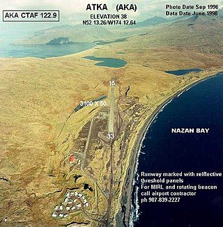
Atka Airport is a state-owned, public use airport located two nautical miles (4 km) north of the central business district of Atka, a city on Atka Island in the U.S. state of Alaska. Scheduled commercial airline passenger service is subsidized by the Essential Air Service program.
Nuiqsut Airport is a public use airport located in Nuiqsut, a city in the North Slope Borough of the U.S. state of Alaska. It is owned by North Slope Borough.
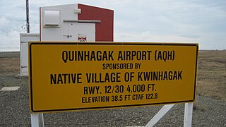
Quinhagak Airport, is a public-use airport located two nautical miles (3.7 km) east of the central business district of Quinhagak, a city in the Bethel Census Area of the U.S. state of Alaska. It is also known as Kwinhagak Airport.

Kobuk Airport is a state-owned public-use airport located in Kobuk, a city in the Northwest Arctic Borough of the U.S. state of Alaska.
Shaktoolik Airport is a state-owned public-use airport located one nautical mile (1.8 km) northwest of the central business district of Shaktoolik, a city in the Nome Census Area of the U.S. state of Alaska.
St. Michael Airport is a state-owned, public-use airport located two nautical miles (4 km) west of the central business district of St. Michael, a city in the Nome Census Area of the U.S. state of Alaska.

Kotlik Airport is a state-owned public-use airport located one nautical mile (1.85 km) west of the central business district of Kotlik, a city in the Kusilvak Census Area of the U.S. state of Alaska.

Larsen Bay Airport is a state-owned public-use airport located in Larsen Bay, a city in the Kodiak Island Borough of the U.S. state of Alaska.

Toksook Bay Airport is a state-owned public-use airport located one nautical mile (1.8 km) east of the central business district of Toksook Bay, a city in the Bethel Census Area of the U.S. state of Alaska.
Sand Point Airport is a state owned, public use airport located two nautical miles (4 km) southwest of the central business district of Sand Point, a city in the Aleutians East Borough in the U.S. state of Alaska. Scheduled airline service to Anchorage International Airport is provided by Peninsula Airways (PenAir).

Willow Airport is a state-owned, public-use airport located one nautical mile (1.85 km) northwest of the central business district of Willow, in the Matanuska-Susitna Borough of the U.S. state of Alaska. It is located across the road from Willow Lake and the Willow Seaplane Base.
Perryville Airport is a state-owned, public-use airport located one nautical mile southwest of the central business district of Perryville, in the Lake and Peninsula Borough of the U.S. state of Alaska. Scheduled airline service to King Salmon Airport is provided by Peninsula Airways (PenAir).
Port Moller Airport is a publicly owned, private-use airport located 87 nautical miles northeast of the central business district of Cold Bay, in the Aleutians East Borough of the U.S. state of Alaska. It is owned by the U.S. Department of the Interior, Bureau of Land Management. It was previously known as Port Moller Air Force Station.
Nelson Lagoon Airport is a state-owned, public-use airport located one nautical mile (1.85 km) east of the central business district of Nelson Lagoon, in the Aleutians East Borough of the U.S. state of Alaska. Scheduled airline service to Cold Bay Airport is provided by Peninsula Airways (PenAir).

Nikolai Airport is a state-owned public-use airport located one nautical mile (1.85 km) northeast of the central business district of Nikolai, a city in the Yukon-Koyukuk Census Area of the U.S. state of Alaska.
Umiat Airport is a state owned, public use airport located in Umiat, in the North Slope Borough of the U.S. state of Alaska. The original runway was created by Seabees of Construction Battalion Detachment 1058 in 1945. They built it to facilitate the resupply of their drilling operation at Umiat.
