Wainwright Airport (Alaska)

Last updated
Wainwright Airport
AWI-Aerial Map.jpg
Summary
Airport typePublic
Owner North Slope Borough
Serves Wainwright, Alaska
Elevation  AMSL 45 ft / 14 m
Coordinates 70°38′17″N159°59′41″W / 70.63806°N 159.99472°W / 70.63806; -159.99472
Map
USA Alaska location map.svg
Airplane silhouette.svg
AIN
Location of airport in Alaska
Runways
Direction LengthSurface
ftm
5/234,4941,370Gravel
Statistics (2006)
Aircraft operations1,100

Wainwright Airport( IATA : AIN, ICAO : PAWI, FAA LID : AWI, formerly 5WW) is a public use airport located in Wainwright, [1] a city in the North Slope Borough of the U.S. state of Alaska. The airport is owned by the North Slope Borough. [1]

Contents

As per Federal Aviation Administration records, the airport had 3,547 passenger boardings (enplanements) in calendar year 2008, [2] 3,770 enplanements in 2009, and 4,129 in 2010. [3] It is included in the National Plan of Integrated Airport Systems for 2011–2015, which categorized it as a non-primary commercial service airport (between 2,500 and 10,000 enplanements per year). [4]

Although many U.S. airports use the same three-letter location identifier for the FAA and IATA, this airport is assigned AWI by the FAA [1] and AIN by the IATA. [5] The airport's ICAO identifier is PAWI. [6] [7]

History

The airport was built in 1957 to support the Distant Early Warning Line Radar station at Wainwright (LIZ-3). The station was logistically supported by the 711th Aircraft Control and Warning Squadron based at Cape Lisburne Air Force Station, although Point Lay was operated by civilian contract workers.

The radar station was upgraded in the late 1980s with new radars and in 1989 was re-designated part of the North Warning System (NWS) as a Long Range Radar Site, A-16. [8] [9] The LRR site was inactivated in 2007 due to soil erosion and budget concerns. The airport remains open to support the small settlement under the control of the Pacific Air Forces Regional Support Center based at Joint Base Elmendorf–Richardson.


Facilities and aircraft

Wainwright Airport resides at elevation of 45 feet (14 m) above mean sea level. It has one runway designated 5/23 with a gravel surface measuring 4,494 by 110 feet (1,370 x 34 m). [1] For the 12-month period ending January 1, 2006, the airport had 1,100 aircraft operations, an average of 91 per month: 73% air taxi and 27% general aviation. [1]

Airlines and destinations

AirlinesDestinations
Wright Air Service Atqasuk, Utqiagvik [10]

Prior to its bankruptcy and cessation of all operations, Ravn Alaska served the airport from multiple locations.

Statistics

Carrier shares: January December 2012 [11]
CarrierPassengers (arriving and departing)
Hageland
6,220(99.4%)
Era Aviation
40(0.6%)
Top domestic destinations: Jan. Dec. 2012 [11]
RankCityAirportPassengers
1 Utqiaġvik, AK Wiley Post/Will Rogers Memorial (BRW) 2,790
2 Atqasuk, AK Atqasuk Edward Burnell Sr. Memorial (ATK) 180

See also

Related Research Articles

<span class="mw-page-title-main">Ambler Airport</span> Airport

Ambler Airport is a state-owned public-use airport located one nautical mile (1.85 km) north of the central business district of Ambler, a city in the Northwest Arctic Borough of the U.S. state of Alaska.

<span class="mw-page-title-main">Atqasuk Edward Burnell Sr. Memorial Airport</span> Airport in Alaska

Atqasuk Edward Burnell Sr. Memorial Airport is an uncontrolled public use airport located one nautical mile (2 km) south of the central business district of Atqasuk, a city in North Slope Borough, Alaska, United States. The airport is owned by North Slope Borough.

<span class="mw-page-title-main">Alakanuk Airport</span> Airport in Alaska, United States of America

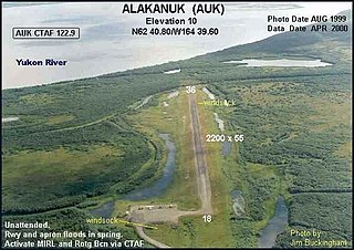
Alakanuk Airport is a state-owned public-use airport located 2 nautical miles (3.7 km) west of the central business district of Alakanuk, a city in the Kusilvak Census Area of the U.S. state of Alaska.

<span class="mw-page-title-main">Haines Airport</span> Airport

Haines Airport is a state-owned public-use airport located three nautical miles (6 km) west of the central business district of Haines, a city in the Haines Borough in the U.S. state of Alaska. It is the primary airport serving the Haines, Klukwan, Haines Borough area and is situated on the Haines Highway, directly adjacent to the Chilkat River.

<span class="mw-page-title-main">Hoonah Airport</span> Airport in Alaska, United States

Hoonah Airport is a state-owned public-use airport located one nautical mile (2 km) southeast of the central business district of Hoonah, Alaska.

<span class="mw-page-title-main">McGrath Airport</span> Airport

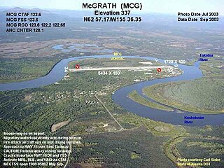
McGrath Airport is a state-owned public-use airport serving McGrath, a city in the Yukon-Koyukuk Census Area of the U.S. state of Alaska.

<span class="mw-page-title-main">Ralph M. Calhoun Memorial Airport</span> Airport

Ralph M. Calhoun Memorial Airport is a state-owned public-use airport located one nautical mile (1.85 km) west of the central business district of Tanana, a city in the Yukon-Koyukuk Census Area of the U.S. state of Alaska.

<span class="mw-page-title-main">Atka Airport</span> Airport in Atka Island

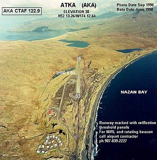
Atka Airport is a state-owned, public use airport located two nautical miles (4 km) north of the central business district of Atka, a city on Atka Island in the U.S. state of Alaska. Scheduled commercial airline passenger service is subsidized by the Essential Air Service program.

Circle City Airport is a state-owned public-use airport located in Circle, in the Yukon-Koyukuk Census Area of the U.S. state of Alaska. It is also known as Circle City (New) Airport. Scheduled commercial airline service is subsidized by the Essential Air Service program.

Egegik Airport is a city-owned, public-use airport serving Egegik, a city in the Lake and Peninsula Borough of the U.S. state of Alaska. Scheduled passenger service is available at this airport.

Nikolski Air Station is an unattended airport located in Nikolski on Umnak Island in the Aleutians West Census Area of the U.S. state of Alaska. This former military airport is now owned by The Aleut Corporation.

Port Alexander Seaplane Base is a city owned, public use seaplane base located in Port Alexander, a city at the southeastern corner of Baranof Island in the Petersburg Borough of the U.S. state of Alaska. It is included in the National Plan of Integrated Airport Systems for 2011–2015, which categorized it as a general aviation facility.

<span class="mw-page-title-main">Anaktuvuk Pass Airport</span> Airport in Alaska, United States

Anaktuvuk Pass Airport is a public use airport located in Anaktuvuk Pass, a city in the North Slope Borough of the U.S. state of Alaska. The airport is owned by North Slope Borough.

<span class="mw-page-title-main">Kobuk Airport</span> Airport

Kobuk Airport is a state-owned public-use airport located in Kobuk, a city in the Northwest Arctic Borough of the U.S. state of Alaska.

Sand Point Airport is a state owned, public use airport located two nautical miles (4 km) southwest of the central business district of Sand Point, a city in the Aleutians East Borough in the U.S. state of Alaska. Scheduled airline service to Anchorage International Airport is provided by Peninsula Airways (PenAir).

<span class="mw-page-title-main">Ruby Airport</span> Airport in Alaska, United States

Ruby Airport is a state-owned public-use airport located one nautical mile (1.85 km) southeast of the central business district of Ruby, a city in the Yukon-Koyukuk Census Area of the U.S. state of Alaska.

<span class="mw-page-title-main">Port Heiden Airport</span> Airport in Alaska, United States of America

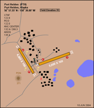
Port Heiden Airport is a state-owned public-use airport located six nautical miles northeast of the central business district of Port Heiden, in the Lake and Peninsula Borough of the U.S. state of Alaska. Scheduled airline service to King Salmon Airport is provided by Peninsula Airways (PenAir).

Port Moller Airport is a publicly owned, private-use airport located 87 nautical miles northeast of the central business district of Cold Bay, in the Aleutians East Borough of the U.S. state of Alaska. It is owned by the U.S. Department of the Interior, Bureau of Land Management. It was previously known as Port Moller Air Force Station.

<span class="mw-page-title-main">Nikolai Airport</span> Airport

Nikolai Airport is a state-owned public-use airport located one nautical mile (1.85 km) northeast of the central business district of Nikolai, a city in the Yukon-Koyukuk Census Area of the U.S. state of Alaska.

Umiat Airport is a state owned, public use airport located in Umiat, in the North Slope Borough of the U.S. state of Alaska. The original runway was created by Seabees of Construction Battalion Detachment 1058 in 1945. They built it to facilitate the resupply of their drilling operation at Umiat.

References

  1. 1 2 3 4 5 6 FAA Airport Form 5010 for AWI PDF . Federal Aviation Administration. effective November 15, 2012.
  2. "Enplanements for CY 2008" (PDF, 1.0 MB). 2008 Passenger Boarding and All-Cargo Data. Federal Aviation Administration. December 18, 2009.
  3. "Enplanements for CY 2010" (PDF, 189 KB). 2010 Passenger Boarding and All-Cargo Data. Federal Aviation Administration. October 4, 2011.
  4. "2011–2015 NPIAS Report, Appendix A" (PDF, 2.03 MB). National Plan of Integrated Airport Systems. Federal Aviation Administration. October 4, 2010.
  5. "IATA Airport Code Search (AIN: Wainwright)". International Air Transport Association . Retrieved July 27, 2013.
  6. "Alaskan ICAO Identifiers". Federal Aviation Administration. Retrieved August 7, 2009.
  7. "Wainwright Airport (IATA: AIN, ICAO: PAWI, FAA: AWI)". Great Circle Mapper. Retrieved August 7, 2009.
  8. PD-icon.svg This article incorporates public domain material from the Air Force Historical Research Agency.
  9. The DEW Line
  10. Wright destinations Retrieved Sep 12, 2022.
  11. 1 2 "Wainwright, AK: Wainwright Airport (AIN)". Bureau of Transportation Statistics. December 2012. Retrieved July 27, 2013.