
Bethel Airport is a state-owned public-use airport located three nautical miles (6 km) southwest of the central business district of Bethel, a city in the Bethel Census Area of the U.S. state of Alaska.

Wainwright Airport is a public use airport located in Wainwright, a city in the North Slope Borough of the U.S. state of Alaska. The airport is owned by the North Slope Borough.

Edward G. Pitka Sr. Airport is a state-owned public-use airport located in Galena, a city in the Yukon-Koyukuk Census Area of the U.S. state of Alaska.
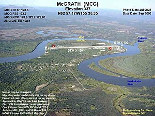
McGrath Airport is a state-owned public-use airport serving McGrath, a city in the Yukon-Koyukuk Census Area of the U.S. state of Alaska.

Ralph M. Calhoun Memorial Airport is a state-owned public-use airport located one nautical mile (1.85 km) west of the central business district of Tanana, a city in the Yukon-Koyukuk Census Area of the U.S. state of Alaska.

Karluk Airport is a state owned, public use airport located one nautical mile (2 km) east of the central business district of Karluk, a community in the Kodiak Island Borough of the U.S. state of Alaska.

Anaktuvuk Pass Airport is a public use airport located in Anaktuvuk Pass, a city in the North Slope Borough of the U.S. state of Alaska. The airport is owned by North Slope Borough.
Nulato Airport is a state-owned public-use airport located one nautical mile (2 km) northeast of the central business district of Nulato, a city in the Yukon-Koyukuk Census Area of the U.S. state of Alaska.

Kobuk Airport is a state-owned public-use airport located in Kobuk, a city in the Northwest Arctic Borough of the U.S. state of Alaska.
Ouzinkie Airport is a state-owned public-use airport serving Ouzinkie, a city on Spruce Island in the Kodiak Island Borough of the U.S. state of Alaska.
Bear Creek 3 Airport is a public-use airport located three nautical miles west of the central business district of Bear Creek, in the Yukon-Koyukuk Census Area of the U.S. state of Alaska. Bear Creek 3 is 40 nautical miles north of McGrath Airport.
Tok Junction Airport is a state-owned public-use airport located one nautical mile east of the central business district of Tok, in the Southeast Fairbanks Census Area of the U.S. state of Alaska.
Venetie Airport is a public use airport located in Venetie, in the Yukon-Koyukuk Census Area of the U.S. state of Alaska. It is privately owned by the Venetie Tribal Government.
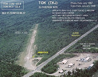
Tok Airport was a state-owned public-use airport located two nautical miles (4 km) south of the central business district of Tok, in the Southeast Fairbanks Census Area of the U.S. state of Alaska.
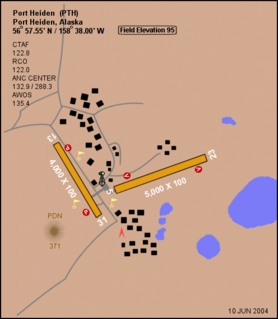
Port Heiden Airport is a state-owned public-use airport located six nautical miles northeast of the central business district of Port Heiden, in the Lake and Peninsula Borough of the U.S. state of Alaska. Scheduled airline service to King Salmon Airport is provided by Peninsula Airways (PenAir).
Port Moller Airport is a publicly owned, private-use airport located 87 nautical miles northeast of the central business district of Cold Bay, in the Aleutians East Borough of the U.S. state of Alaska. It is owned by the U.S. Department of the Interior, Bureau of Land Management. It was previously known as Port Moller Air Force Station.
Point Lonely Short Range Radar Site is a United States Air Force Short Range Radar Site located in the North Slope Borough of the U.S. state of Alaska, 84 miles (135 km) east-southeast of Point Barrow, Alaska. It is not open for public access.
Driftwood Bay Air Force Station is a private use military airstrip located 13 nautical miles northwest of Dutch Harbor, in the Aleutians East Borough of the U.S. state of Alaska. It is privately owned by the United States Air Force. The facility is not open for public use.
Lost River 1 Airport is an airport located at Lost River, in the Nome Census Area of the U.S. state of Alaska.
Gold King Creek Airport is a public-use airport located at 64°11′53″N147°55′43″W. It is 39 nautical miles southeast of Fairbanks, Alaska, and is owned by the State of Alaska DOT&PF.

