
Chevak Airport is a publicly owned airport located one mile (1.6 km) north of the central business district of Chevak, a city in the Kusilvak Census Area of the U.S. state of Alaska. The airport is owned by the state.
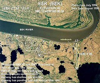
Eek Airport is a state-owned public-use airport serving the city of Eek in the Bethel Census Area of the U.S. state of Alaska.
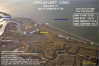
Unalakleet Airport is a state-owned public-use airport located one nautical mile (2 km) north of the central business district of Unalakleet, a city in the Nome Census Area of the U.S. state of Alaska.
Crooked Creek Airport is a public airport located two miles (3 km) south of the central business district of Crooked Creek, in the U.S. state of Alaska.

Kasigluk Airport is a state-owned public-use airport located two nautical miles (4 km) south of the central business district of Kasigluk, in the Bethel Census Area of the U.S. state of Alaska.
Kalskag Airport is a public airport located one mile (1.6 km) west of the central business district of Upper Kalskag, a city in the Bethel Census Area of the U.S. state of Alaska. The airport is owned by the state. It is situated on the Kuskokwim River, between the cities of Upper Kalskag and Lower Kalskag.
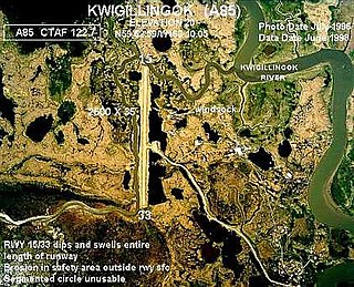
Kwigillingok Airport is owned by the Native Village of Kwigillingok and is a public-use airport located one mile northwest of the central business district of Kwigillingok, in the Bethel Census Area of the U.S. state of Alaska. There is also a nearby seaplane landing area known as Kwigillingok Seaplane Base.

Kwethluk Airport is a state-owned public-use airport located in Kwethluk, a city in the Bethel Census Area of the U.S. state of Alaska.

Shishmaref Airport is a state-owned public-use airport located one nautical mile (1.85 km) south of the central business district of Shishmaref, a village in the Nome Census Area of the U.S. state of Alaska. It has one asphalt paved runway designated 5/23 and measuring 5,000 x 70 ft.. Shishmaref is located on Sarichef Island in the Chukchi Sea, just north of the Bering Strait and five miles from the mainland.
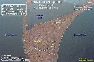
Point Hope Airport is a state-owned public-use airport located two miles (3 km) southwest of the central business district of Point Hope, a city in the North Slope Borough of the U.S. state of Alaska. Point Hope is located in the Lisburne Peninsula, on the Chukchi Sea coast.
Teller Airport is a state-owned public-use airport located two nautical miles (4 km) south of the central business district of Teller, a city in the Nome Census Area of the U.S. state of Alaska.
Shaktoolik Airport is a state-owned public-use airport located one nautical mile (1.8 km) northwest of the central business district of Shaktoolik, a city in the Nome Census Area of the U.S. state of Alaska.
St. Michael Airport is a state-owned, public-use airport located two nautical miles (4 km) west of the central business district of St. Michael, a city in the Nome Census Area of the U.S. state of Alaska.

Kotlik Airport is a state-owned public-use airport located one nautical mile (1.85 km) west of the central business district of Kotlik, a city in the Kusilvak Census Area of the U.S. state of Alaska.

Atmautluak Airport is a state-owned public-use airport located in Atmautluak, in the Bethel Census Area of the U.S. state of Alaska.
Tok Junction Airport is a state-owned public-use airport located one nautical mile east of the central business district of Tok, in the Southeast Fairbanks Census Area of the U.S. state of Alaska.

Tuntutuliak Airport is an airport situated in the US. It is a state-owned public-use airport located one nautical mile (1.85 km) south of the central business district of Tuntutuliak, in the Bethel Census Area of the U.S. state of Alaska.
Mekoryuk Airport is a state-owned public-use airport located three nautical miles (5.5 km) west of the central business district of Mekoryuk, a city in the Bethel Census Area, on Nunivak Island, of the U.S. state of Alaska. Airport operations began in October 1960.
Red Devil Airport is a public use airport located one nautical mile (1.85 km) northwest of the central business district of Red Devil, in Bethel Census Area of the U.S. state of Alaska.

Tununak Airport is a state-owned, public-use airport located one nautical mile (1.85 km) southwest of the central business district of Tununak, in the Bethel Census Area of the U.S. state of Alaska.
