Elim Airport

Last updated • 1 min readFrom Wikipedia, The Free Encyclopedia
Elim Airport
ELI-g.jpg
Summary
Airport typePublic
Owner State of Alaska DOT&PF - Northern Region
Serves Elim, Alaska
Elevation  AMSL 162 ft / 49 m
Coordinates 64°36′54″N162°16′14″W / 64.61500°N 162.27056°W / 64.61500; -162.27056
Map
USA Alaska location map.svg
Airplane silhouette.svg
ELI
Location of airport in Alaska
Runways
Direction LengthSurface
ftm
1/193,4011,037Gravel
Statistics (2018)
Based aircraft (2018)0
Passengers4,298
Freight732,000 lbs

Elim Airport( IATA : ELI [3] , ICAO : PFEL [4] , FAA LID : ELI) is a state-owned, public-use airport located three nautical miles (6 km) southwest of the central business district of Elim, [1] a city in the Nome Census Area of the U.S. state of Alaska.

Contents

This airport is included in the FAA's National Plan of Integrated Airport Systems for 2009–2013, where it is listed as commercial service - non-primary, an FAA category for airports with 2,500 to 10,000 passenger boardings (enplanements) per year. [5] However, Federal Aviation Administration records for calendar year 2008 categorized it as general aviation based on 2,356 enplanements that year, a decrease of 26.1% from the 3,189 enplanements in 2007. [2]

Facilities

Elim Airport covers an area of 181 acres (73 ha) at an elevation of 162 feet (49 m) above mean sea level. It has one runway designated 1/19 with a gravel surface measuring 3,401 by 60 feet (1,037 x 18 m). [1]

Airlines and destinations

AirlinesDestinations
Bering Air Golovin, Nome, White Mountain [6]

Prior to its bankruptcy and cessation of all operations, Ravn Alaska served the airport from multiple locations.

Statistics

Carrier shares: January – December 2016 [7]
Carrier  Passengers (arriving and departing)
Bering
3,660(80.09%)
Hageland
910(19.91%)
Top domestic destinations: January – December 2016 [7]
RankCityAirportPassengers
1 Flag of Alaska.svg Nome, AK Nome Airport 1,610
2 Flag of Alaska.svg Unalakleet, AK Unalakleet Airport 280
3 Flag of Alaska.svg Koyuk, AK Koyuk Alfred Adams Airport 160
4 Flag of Alaska.svg Golovin, AK Golovin Airport 130
5 Flag of Alaska.svg Shaktoolik, AK Shaktoolik Airport 40
Flag of Alaska.svg White Mountain, AK White Mountain Airport 40

See also

Related Research Articles

<span class="mw-page-title-main">Nome Airport</span> Airport

Nome Airport is a state-owned public-use airport located two nautical miles (4 km) west of the central business district of Nome, a city in the Nome Census Area of the U.S. state of Alaska.

<span class="mw-page-title-main">Ambler Airport</span> Airport

Ambler Airport is a state-owned public-use airport located one nautical mile (1.85 km) north of the central business district of Ambler, a city in the Northwest Arctic Borough of the U.S. state of Alaska.

<span class="mw-page-title-main">Atqasuk Edward Burnell Sr. Memorial Airport</span> Airport in Alaska

Atqasuk Edward Burnell Sr. Memorial Airport is an uncontrolled public use airport located one nautical mile (2 km) south of the central business district of Atqasuk, a city in North Slope Borough, Alaska, United States. The airport is owned by North Slope Borough.

<span class="mw-page-title-main">Alakanuk Airport</span> Airport in Alaska, United States of America

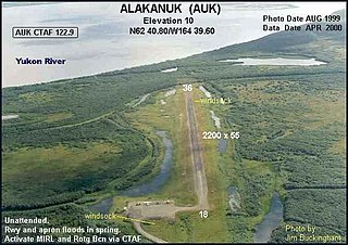
Alakanuk Airport is a state-owned public-use airport located 2 nautical miles (3.7 km) west of the central business district of Alakanuk, a city in the Kusilvak Census Area of the U.S. state of Alaska.

<span class="mw-page-title-main">McGrath Airport</span> Airport

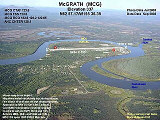
McGrath Airport is a state-owned public-use airport serving McGrath, a city in the Yukon-Koyukuk Census Area of the U.S. state of Alaska.

Circle City Airport is a state-owned public-use airport located in Circle, in the Yukon-Koyukuk Census Area of the U.S. state of Alaska. It is also known as Circle City (New) Airport. Scheduled commercial airline service is subsidized by the Essential Air Service program.

Egegik Airport is a city-owned, public-use airport serving Egegik, a city in the Lake and Peninsula Borough of the U.S. state of Alaska. Scheduled passenger service is available at this airport.

Golovin Airport is a state-owned public-use airport located in Golovin, a city in the Nome Census Area of the U.S. state of Alaska.

<span class="mw-page-title-main">Anaktuvuk Pass Airport</span> Airport in Alaska, United States

Anaktuvuk Pass Airport is a public use airport located in Anaktuvuk Pass, a city in the North Slope Borough of the U.S. state of Alaska. The airport is owned by North Slope Borough.

<span class="mw-page-title-main">Brevig Mission Airport</span> Airport

Brevig Mission Airport is a state-owned public-use airport located in Brevig Mission, a city in the Nome Census Area of the U.S. state of Alaska.

<span class="mw-page-title-main">White Mountain Airport</span> Airport

White Mountain Airport is a state-owned public-use airport located one nautical mile north of the central business district of White Mountain, a city in the Nome Census Area of the U.S. state of Alaska.

<span class="mw-page-title-main">Allakaket Airport</span> Airport

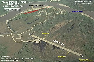
Allakaket Airport, is a state-owned public-use airport located two nautical miles (4 km) north-northwest of the central business district of Allakaket, a city in the Yukon-Koyukuk Census Area of the U.S. state of Alaska. The airport is sometimes referred to as the New Allakaket Airport because it was constructed on a site southeast of the original airport which is now closed.

<span class="mw-page-title-main">Shishmaref Airport</span> Airport

Shishmaref Airport is a state-owned public-use airport located one nautical mile (1.85 km) south of the central business district of Shishmaref, a village in the Nome Census Area of the U.S. state of Alaska. It has one asphalt paved runway designated 5/23 and measuring 5,000 x 70 ft.. Shishmaref is located on Sarichef Island in the Chukchi Sea, just north of the Bering Strait and five miles from the mainland.

<span class="mw-page-title-main">Kobuk Airport</span> Airport

Kobuk Airport is a state-owned public-use airport located in Kobuk, a city in the Northwest Arctic Borough of the U.S. state of Alaska.

<span class="mw-page-title-main">Larsen Bay Airport</span> Airport

Larsen Bay Airport is a state-owned public-use airport located in Larsen Bay, a city in the Kodiak Island Borough of the U.S. state of Alaska.

False Pass Airport is a state owned, public use airport in False Pass, a city in the Aleutians East Borough of the U.S. state of Alaska. Scheduled airline service to Cold Bay Airport and Akutan Airport is provided by Grant Aviation

<span class="mw-page-title-main">Akiak Airport</span> Airport

Akiak Airport is a state-owned public-use airport serving Akiak, a city in the Bethel Census Area of the U.S. state of Alaska.

<span class="mw-page-title-main">Napaskiak Airport</span> Airport in Alaska, United States

Napaskiak Airport is a state-owned, public-use airport located one nautical mile southwest of the central business district of Napaskiak, a city in the Bethel Census Area of the U.S. state of Alaska.

Clarks Point Airport is a state-owned public-use airport located in Clarks Point, a city in the Dillingham Census Area of the U.S. state of Alaska.

<span class="mw-page-title-main">Nikolai Airport</span> Airport

Nikolai Airport is a state-owned public-use airport located one nautical mile (1.85 km) northeast of the central business district of Nikolai, a city in the Yukon-Koyukuk Census Area of the U.S. state of Alaska.

References

  1. 1 2 3 FAA Airport Form 5010 for ELI PDF . Federal Aviation Administration. effective April 27, 2017.
  2. 1 2 CY 2008 Passenger Boarding and All-Cargo Data. Federal Aviation Administration. Updated May 7, 2017.
  3. ELI: Elim Airport, Alaska. Aviation Safety Network. Retrieved 2008-09-21.
  4. PFEL: Elim Airport, Alaska. AirNav.com. Retrieved 2008-09-21.
  5. National Plan of Integrated Airport Systems for 2009–2013: Appendix A: Part 1 (PDF, 1.33 MB) Archived August 6, 2011, at the Wayback Machine . Federal Aviation Administration. Updated 15 October 2008.
  6. Bering Air Nome & Unalakleet Schedule (PDF). Bering Air. Retrieved Sep 10, 2022.
  7. 1 2 "Elim, AK: Elim (ELI)". Bureau of Transportation Statistics (BTS), Research and Innovative Technology Administration (RITA), U.S. Department of Transportation. December 2016. Retrieved May 7, 2017.