Edward G. Pitka Sr. Airport

Last updated

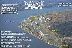
Edward G. Pitka Sr. Airport

(former Galena Air Force Base)
GAL-i.jpg
Summary
Airport typePublic
Owner State of Alaska DOT&PF – Northern Region
Serves Galena, Alaska
Elevation  AMSL 154 ft / 47 m
Coordinates 64°44′10″N156°56′15″W / 64.73611°N 156.93750°W / 64.73611; -156.93750
Map
USA Alaska location map.svg
Airplane silhouette.svg
GAL
Location of airport in Alaska
Runways
Direction LengthSurface
ftm
8/266,0001,829Asphalt/Concrete
6/242,600792Gravel Ski Strip
Statistics (2022)
Aircraft operations19,000
Based aircraft0
Galena Airport was used by the USAF 317th Fighter-Interceptor Squadron at Elmendorf AFB as a forward-deployed Base to intercept Soviet aircraft intruding on United States airspace over the Bering Sea. Depicted: Convair F-102 Delta Dagger, 1965. 317th Fighter-Interceptor Squadron Convair F-102A-70-CO Delta Dagger 56-1257.jpg
Galena Airport was used by the USAF 317th Fighter-Interceptor Squadron at Elmendorf AFB as a forward-deployed Base to intercept Soviet aircraft intruding on United States airspace over the Bering Sea. Depicted: Convair F-102 Delta Dagger, 1965.

Edward G. Pitka Sr. Airport( IATA : GAL, ICAO : PAGA, FAA LID : GAL) is a state-owned public-use airport located in Galena, a city in the Yukon-Koyukuk Census Area of the U.S. state of Alaska. [1]

Contents

As per Federal Aviation Administration records, the airport had 7,784 passenger boardings (enplanements) in calendar year 2008, [2] 7,447 enplanements in 2009, and 12,421 in 2010. [3] It is included in the National Plan of Integrated Airport Systems for 2011–2015, which categorized it as a non-primary commercial service airport (between 2,500 and 10,000 enplanements per year) based on enplanements in 2008; [4] however, it qualifies as a primary commercial service airport based on enplanements in 2010.

History

As Galena Airport, it was used as a military transport base during World War II, facilitating the transit of lend-lease aircraft to the Soviet Union.

As Galena Air Force Station, it was used by the USAF during the Cold War as an interceptor base for aircraft patrolling the western areas of Alaska. It was downsized in 1993, but the military airfield is maintained by a private contractor as a weather/emergency diversion airfield since Regular Air Force fighter-interceptor alert operations ended. [5] It is now known as Galena Forward Operating Location.[ citation needed ]

Facilities and aircraft

Edward G. Pitka Sr Airport covers an area of 1,250 acres (506 ha) at an elevation of 154 feet (47 m) above mean sea level. It has two runways: 8/26 is 6,000 by 100 feet (1,829 x 30 m) with an asphalt and concrete surface; 6/24 is 2,600 by 50 feet (792 x 15 m) with a gravel ski strip surface. [1]

The airport also sports a ski-jump takeoff ramp at one end and provisions for arresting gear (see picture, ski jump at 07 end) at the other, a leftover from the Cold War years as Galena Air Force Base, as tactical aircraft required more landing and takeoff space than was available on the runway.

For the 12-month period ending December 31, 2022, the airport had 19,000 aircraft operations, an average of 52 per day: 68% general aviation, 16% scheduled commercial, 11% military, and 5% air taxi. At that time there was no aircraft based at the airport. [1]

Airlines and destinations

Passenger

AirlinesDestinations
Everts Air Fairbanks [6]
Wright Air Service Fairbanks, Huslia, Kaltag, Koyukuk, Nulato, Ruby [7]

Prior to its bankruptcy and cessation of all operations, Ravn Alaska served the airport from multiple locations.

Top destinations

Busiest domestic routes out of GAL
(Dec. 2015 – Nov. 2016) [8]
RankCityPassengersCarriers
1 Fairbanks, AK 7,050Ravn Alaska
2 Nulato, AK 1,170Ravn Alaska
3 Kaltag, AK 920Ravn Alaska, Wright
4 Huslia, AK 270Ravn Alaska
5 Koyukuk, AK 210Ravn Alaska
6 Ruby, AK 110Ravn Alaska

See also

Related Research Articles

<span class="mw-page-title-main">Alliance Municipal Airport</span> Airport

Alliance Municipal Airport is in Box Butte County, Nebraska, three miles southeast of the city of Alliance, which owns it. Denver Air Connection offers scheduled passenger flights to Denver, which are subsidized by the Essential Air Service program.

<span class="mw-page-title-main">Juneau International Airport</span> International airport serving Juneau, Alaska, United States

Juneau International Airport is a city-owned, public-use airport and seaplane base located seven nautical miles northwest of the central business district of Juneau, a city and borough in the U.S. state of Alaska that has no direct road access to the outside world. The airport serves as a regional hub for all air travel, from bush carriers to major U.S. air carriers such as Alaska Airlines.

<span class="mw-page-title-main">Dothan Regional Airport</span> Airport in Dale County, Alabama

Dothan Regional Airport is a public airport in Dale County, Alabama, United States, seven miles northwest of Dothan, a city mostly in Houston County.

<span class="mw-page-title-main">Sitka Rocky Gutierrez Airport</span> Airport in Japonski Island

Sitka Rocky Gutierrez Airport is a state-owned, public-use airport located west of the central business district of Sitka, a city and borough in the U.S. state of Alaska.

<span class="mw-page-title-main">Yakutat Airport</span> Airport serving Yakutat, Alaska, United States

Yakutat Airport is a state-owned public-use airport located three nautical miles (6 km) southeast of the central business district of Yakutat, a city and borough in the U.S. state of Alaska which has no road access to the outside world. Airline service is subsidized by the Essential Air Service program.

<span class="mw-page-title-main">Bethel Airport</span> Airport

Bethel Airport is a state-owned public-use airport located three nautical miles (6 km) southwest of the central business district of Bethel, a city in the Bethel Census Area of the U.S. state of Alaska.

<span class="mw-page-title-main">King Salmon Airport</span> Airport in Alaska, United States

King Salmon Airport is a state-owned public-use airport located just southeast of King Salmon, in the Bristol Bay Borough of the U.S. state of Alaska. It was formerly the Naknek Air Force Base, named for its location near the Naknek River.

<span class="mw-page-title-main">Dillingham Airport</span> Airport

Dillingham Airport is a state-owned public-use airport located two nautical miles (4 km) west of the central business district of Dillingham, a city in the Dillingham Census Area of the U.S. state of Alaska. Scheduled passenger service is available at this airport.

<span class="mw-page-title-main">Nome Airport</span> Airport

Nome Airport is a state-owned public-use airport located two nautical miles (4 km) west of the central business district of Nome, a city in the Nome Census Area of the U.S. state of Alaska.

<span class="mw-page-title-main">Cold Bay Airport</span> Airport

Cold Bay Airport is a state owned, public use airport located in Cold Bay, a city in the Aleutians East Borough of the U.S. state of Alaska. First built as a United States Army Air Forces airfield during World War II, it is one of the main airports serving the Alaska Peninsula. Scheduled passenger service is available and air taxi operators fly in and out of the airport daily. Formerly, the airport operated as Thornbrough Air Force Base.

<span class="mw-page-title-main">Wainwright Airport (Alaska)</span> Airport

Wainwright Airport is a public use airport located in Wainwright, a city in the North Slope Borough of the U.S. state of Alaska. The airport is owned by the North Slope Borough.

<span class="mw-page-title-main">Unalaska Airport</span> Airport in Amaknak Island

Tom Madsen Airport is a state-owned public-use airport in City of Unalaska, on Amaknak Island in the Aleutian Islands, off the coast of the U.S. state of Alaska. It is located near the Bering Sea coast of Unalaska Island, 800 miles (1,300 km) southwest of Anchorage and 1,950 miles (3,140 km) from Seattle.

<span class="mw-page-title-main">Atqasuk Edward Burnell Sr. Memorial Airport</span> Airport in Alaska

Atqasuk Edward Burnell Sr. Memorial Airport is an uncontrolled public use airport located one nautical mile (2 km) south of the central business district of Atqasuk, a city in North Slope Borough, Alaska, United States. The airport is owned by North Slope Borough.

<span class="mw-page-title-main">Haines Airport</span> Airport

Haines Airport is a state-owned public-use airport located three nautical miles (6 km) west of the central business district of Haines, a city in the Haines Borough in the U.S. state of Alaska. It is the primary airport serving the Haines, Klukwan, Haines Borough area and is situated on the Haines Highway, directly adjacent to the Chilkat River.

<span class="mw-page-title-main">Skagway Airport</span> Airport

Skagway Airport is a state-owned public-use airport in the city of Skagway, Alaska.

<span class="mw-page-title-main">Hoonah Airport</span> Airport in Alaska, United States

Hoonah Airport is a state-owned public-use airport located one nautical mile (2 km) southeast of the central business district of Hoonah, Alaska.

<span class="mw-page-title-main">McGrath Airport</span> Airport

McGrath Airport is a state-owned public-use airport serving McGrath, a city in the Yukon-Koyukuk Census Area of the U.S. state of Alaska.

<span class="mw-page-title-main">Ketchikan Harbor Seaplane Base</span> Airport

Ketchikan Harbor Seaplane Base is a privately owned, public use seaplane base located at the harbor of Ketchikan, a city in the Ketchikan Gateway Borough of the U.S. state of Alaska. It is located near the Ketchikan International Airport, which also has its own seaplane landing area. Prior to the opening of the Ketchikan International Airport in 1973, scheduled passenger seaplane service was operated with amphibian aircraft between the seaplane base and the Annette Island Airport located approximately 20 miles south, as this land plane airfield previously served as the primary airport for Ketchikan, with scheduled airline flights being operated by Pan American World Airways, Pacific Northern Airlines and Western Airlines into Annette Island over the years.

Venetie Airport is a public use airport located in Venetie, in the Yukon-Koyukuk Census Area of the U.S. state of Alaska. It is privately owned by the Venetie Tribal Government.

Delta Junction Airport is a public use airport located in and owned by Delta Junction, a city in the Southeast Fairbanks Census Area of the U.S. state of Alaska.

References

  1. 1 2 3 4 FAA Airport Form 5010 for GAL PDF . Federal Aviation Administration. effective May 31, 2012.
  2. "Enplanements for CY 2008" (PDF, 1.0 MB). CY 2008 Passenger Boarding and All-Cargo Data. Federal Aviation Administration. December 18, 2009.
  3. "Enplanements for CY 2010" (PDF, 189 KB). CY 2010 Passenger Boarding and All-Cargo Data. Federal Aviation Administration. October 4, 2011.
  4. "2011–2015 NPIAS Report, Appendix A" (PDF). National Plan of Integrated Airport Systems. Federal Aviation Administration. October 4, 2010. Archived from the original (PDF, 2.03 MB) on September 27, 2012.
  5. PD-icon.svg This article incorporates public domain material from the Air Force Historical Research Agency.
  6. "Passenger Schedules" . Retrieved December 20, 2020.
  7. "Wright Destinations" . Retrieved September 16, 2022.
  8. http://www.transtats.bts.gov/airports.asp?pn=1&Airport=GAL&Airport_Name=Galena,%20AK:%20Galena%20Airport&carrier=FACTS [ bare URL ]