
Juneau International Airport is a city-owned, public-use airport and seaplane base located seven nautical miles northwest of the central business district of Juneau, a city and borough in the U.S. state of Alaska that has no direct road access to the outside world. The airport serves as a regional hub for all air travel, from bush carriers to major U.S. air carriers such as Alaska Airlines.
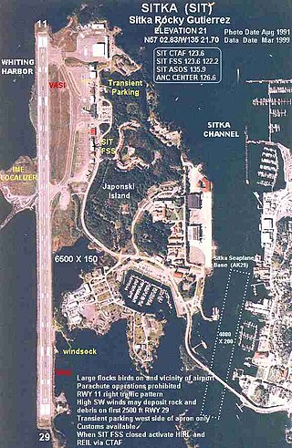
Sitka Rocky Gutierrez Airport is a state-owned, public-use airport located west of the central business district of Sitka, a city and borough in the U.S. state of Alaska.

Nome Airport is a state-owned public-use airport located two nautical miles (4 km) west of the central business district of Nome, a city in the Nome Census Area of the U.S. state of Alaska.

Merrill Field is a public-use general aviation airport located one mile (1.6 km) east of downtown Anchorage in the U.S. state of Alaska. The airport is owned by Municipality of Anchorage. It opened in 1930 as Anchorage Aviation Field and was renamed in honor of Alaska aviation pioneer Russel Merrill.
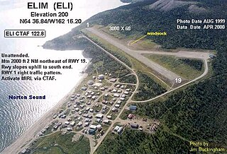
Elim Airport is a state-owned, public-use airport located three nautical miles (6 km) southwest of the central business district of Elim, a city in the Nome Census Area of the U.S. state of Alaska.
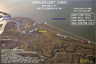
Unalakleet Airport is a state-owned public-use airport located one nautical mile (2 km) north of the central business district of Unalakleet, a city in the Nome Census Area of the U.S. state of Alaska.

Gambell Airport is a public airport located in Gambell, a city in the Nome Census Area of the U.S. state of Alaska. The airport is owned by the state.
Koyuk Alfred Adams Airport is a state-owned public-use airport located in Koyuk, a city in the Nome Census Area of the U.S. state of Alaska.

White Mountain Airport is a state-owned public-use airport located one nautical mile north of the central business district of White Mountain, a city in the Nome Census Area of the U.S. state of Alaska.

Shishmaref Airport is a state-owned public-use airport located one nautical mile (1.85 km) south of the central business district of Shishmaref, a village in the Nome Census Area of the U.S. state of Alaska. It has one asphalt paved runway designated 5/23 and measuring 5,000 x 70 ft.. Shishmaref is located on Sarichef Island in the Chukchi Sea, just north of the Bering Strait and five miles from the mainland.
Wales Airport is a state-owned public-use airport located one nautical mile (2 km) northwest of the central business district of Wales, a city in the Nome Census Area of the U.S. state of Alaska.
Teller Airport is a state-owned public-use airport located two nautical miles (4 km) south of the central business district of Teller, a city in the Nome Census Area of the U.S. state of Alaska.
Stebbins Airport is a state-owned public-use airport located in Stebbins, in the Nome Census Area, Alaska, United States.
Shaktoolik Airport is a state-owned public-use airport located one nautical mile (1.8 km) northwest of the central business district of Shaktoolik, a city in the Nome Census Area of the U.S. state of Alaska.
Savoonga Airport is a state-owned public-use airport located two nautical miles (4 km) south of the central business district of Savoonga, a city in the Nome Census Area of the U.S. state of Alaska. Savoonga is located on St. Lawrence Island in the Bering Sea.
St. Michael Airport is a state-owned, public-use airport located two nautical miles (4 km) west of the central business district of St. Michael, a city in the Nome Census Area of the U.S. state of Alaska.
Port Clarence Coast Guard Station is a private-use airport located one nautical mile (2 km) northeast of the central business district of Port Clarence in the Nome Census Area of the U.S. state of Alaska. It is owned by the U.S. Government.
Tin City LRRS Airport is a military airport located one nautical mile (1.85 km) east of the historic location of Tin City, in the Nome Census Area of the U.S. state of Alaska. It is owned by the U.S. Air Force.
Council Airport is a state-owned public-use airport located one nautical mile (1.8 km) north of the central business district of Council, in the Nome Census Area in the U.S. state of Alaska.

Moses Point Airport is an airport located in Elim, a city in the Nome Census Area of the U.S. state of Alaska. It is privately owned by the Elim Native Corporation. Formerly, the field operated as Moses Point Army Airfield during World War II.
