
Wainwright Airport is a public use airport located in Wainwright, a city in the North Slope Borough of the U.S. state of Alaska. The airport is owned by the North Slope Borough.

Atqasuk Edward Burnell Sr. Memorial Airport is an uncontrolled public use airport located one nautical mile (2 km) south of the central business district of Atqasuk, a city in North Slope Borough, Alaska, United States. The airport is owned by North Slope Borough.
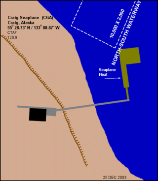
Craig Seaplane Base is a public use seaplane base owned by and located in Craig, a city in the Prince of Wales-Hyder Census Area of the U.S. state of Alaska.

Haines Airport is a state-owned public-use airport located three nautical miles (6 km) west of the central business district of Haines, a city in the Haines Borough in the U.S. state of Alaska. It is the primary airport serving the Haines, Klukwan, Haines Borough area and is situated on the Haines Highway, directly adjacent to the Chilkat River.
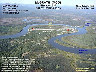
McGrath Airport is a state-owned public-use airport serving McGrath, a city in the Yukon-Koyukuk Census Area of the U.S. state of Alaska.

Ralph M. Calhoun Memorial Airport is a state-owned public-use airport located one nautical mile (1.85 km) west of the central business district of Tanana, a city in the Yukon-Koyukuk Census Area of the U.S. state of Alaska.
Egegik Airport is a city-owned, public-use airport serving Egegik, a city in the Lake and Peninsula Borough of the U.S. state of Alaska. Scheduled passenger service is available at this airport.

Anaktuvuk Pass Airport is a public use airport located in Anaktuvuk Pass, a city in the North Slope Borough of the U.S. state of Alaska. The airport is owned by North Slope Borough.

Kobuk Airport is a state-owned public-use airport located in Kobuk, a city in the Northwest Arctic Borough of the U.S. state of Alaska.

Larsen Bay Airport is a state-owned public-use airport located in Larsen Bay, a city in the Kodiak Island Borough of the U.S. state of Alaska.
Sand Point Airport is a state owned, public use airport located two nautical miles (4 km) southwest of the central business district of Sand Point, a city in the Aleutians East Borough in the U.S. state of Alaska. Scheduled airline service to Anchorage International Airport is provided by Peninsula Airways (PenAir).
Port Lions Airport is a state-owned, public-use airport located two nautical miles northeast of the central business district of Port Lions, a city located on Kodiak Island in the Kodiak Island Borough of the U.S. state of Alaska.
Port Protection Seaplane Base is a state owned, public use seaplane base located in Port Protection, a community in the Prince of Wales-Hyder Census Area of the U.S. state of Alaska. It is included in the National Plan of Integrated Airport Systems for 2011–2015, which categorized it as a general aviation facility.

Hollis Clark Bay Seaplane Base is a state owned, public use seaplane base located one nautical mile (2 km) northeast of the central business district of Hollis, a community in the Prince of Wales-Hyder Census Area in the U.S. state of Alaska. It was formerly known as Hollis Seaplane Base.

Stony River Airport, also known as Stony River 2 Airport, is a state-owned public-use airport located in Stony River, in the Bethel Census Area of the U.S. state of Alaska.
Chandalar Lake Airport is a state-owned public-use airport located at Chandalar Lake in Alaska. This airport is included in the National Plan of Integrated Airport Systems for 2011–2015, which categorized it as a general aviation airport.
Portage Creek Airport is a state-owned public-use airport in Portage Creek, located in the Dillingham Census Area of the U.S. state of Alaska. This airport is included in the FAA's National Plan of Integrated Airport Systems for 2011–2015, which categorized it as a general aviation airport.
Ugashik Airport is a state-owned public-use airport located one nautical mile (2 km) north of the central business district of Ugashik, in the Lake and Peninsula Borough of the U.S. state of Alaska. It is included in the National Plan of Integrated Airport Systems for 2011–2015, which categorized it as a general aviation airport.
Dahl Creek Airport is a state owned, public use airport located 10 nautical miles (19 km) southeast of Dahl Creek, in the Northwest Arctic Borough of the U.S. state of Alaska.
Takotna Airport is a state-owned public-use airport located one nautical mile (2 km) north of Takotna, in the Yukon-Koyukuk Census Area of the U.S. state of Alaska.
