
Lake Hood Seaplane Base is a state-owned seaplane base located three nautical miles (6 km) southwest of the central business district of Anchorage in the U.S. state of Alaska. The Lake Hood Strip is a gravel runway located adjacent to the seaplane base. The gravel strip airport's previous code of has been decommissioned and combined with as another landing surface.

Buckland Airport is a state-owned public-use airport located one nautical mile (1.85 km) southwest of the central business district of Buckland, a city in the Northwest Arctic Borough of the U.S. state of Alaska. The airport is situated on the Buckland River.
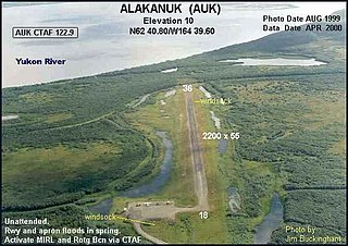
Alakanuk Airport is a state-owned public-use airport located 2 nautical miles (3.7 km) west of the central business district of Alakanuk, a city in the Kusilvak Census Area of the U.S. state of Alaska.

Emmonak Airport is a state-owned public-use airport located in Emmonak, a city in the Kusilvak Census Area of the U.S. state of Alaska.

Kasigluk Airport is a state-owned public-use airport located two nautical miles (4 km) south of the central business district of Kasigluk, in the Bethel Census Area of the U.S. state of Alaska.
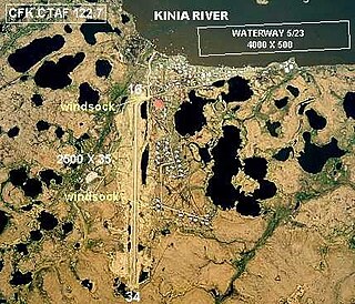
Chefornak Airport is a state-owned public-use airport in Chefornak, a city in the Bethel Census Area of the U.S. state of Alaska. The airport is on the Kinia River.

Kipnuk Airport is a state-owned public-use airport serving Kipnuk, in the Bethel Census Area of the U.S. state of Alaska.

Kongiganak Airport is a state-owned public-use airport located adjacent to the village of Kongiganak, in the Bethel Census Area of the U.S. state of Alaska.

Kobuk Airport is a state-owned public-use airport located in Kobuk, a city in the Northwest Arctic Borough of the U.S. state of Alaska.
Old Harbor Airport is a state owned, public use airport located two nautical miles (4 km) northeast of the central business district of Old Harbor, a city in the Kodiak Island Borough in the U.S. state of Alaska.
Ouzinkie Airport is a state-owned public-use airport serving Ouzinkie, a city on Spruce Island in the Kodiak Island Borough of the U.S. state of Alaska.
Bear Creek 3 Airport is a public-use airport located three nautical miles west of the central business district of Bear Creek, in the Yukon-Koyukuk Census Area of the U.S. state of Alaska. Bear Creek 3 is 40 nautical miles north of McGrath Airport.
Boswell Bay Airport is owned by the U.S. Forest Service and is located near Boswell Bay, in the Valdez–Cordova Census Area, Alaska of the U.S. state of Alaska. The airfield was constructed in 1968 to serve the nearby White Alice radar site, now abandoned.
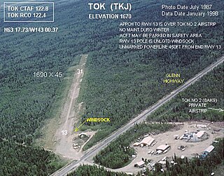
Tok Junction Airport is a state-owned public-use airport located one nautical mile east of the central business district of Tok, in the Southeast Fairbanks Census Area of the U.S. state of Alaska.
Tok Airport was a state-owned public-use airport located two nautical miles (4 km) south of the central business district of Tok, in the Southeast Fairbanks Census Area of the U.S. state of Alaska.
Perryville Airport is a state-owned, public-use airport located one nautical mile southwest of the central business district of Perryville, in the Lake and Peninsula Borough of the U.S. state of Alaska. Scheduled airline service to King Salmon Airport is provided by Peninsula Airways (PenAir).
Chignik Airport is a state-owned, public-use airport two nautical miles (3.7 km) northeast of the central business district of Chignik, a city in the Lake and Peninsula Borough of the U.S. state of Alaska.

Stony River Airport, also known as Stony River 2 Airport, is a state-owned public-use airport located in Stony River, in the Bethel Census Area of the U.S. state of Alaska.
Gold King Creek Airport is a public-use airport located at 64°11′53″N147°55′43″W. It is 39 nautical miles southeast of Fairbanks, Alaska, and is owned by the State of Alaska DOT&PF.
Wainwright Air Station is a military airport located in Wainwright, Alaska. It is owned by the United States Air Force.
