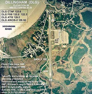
Dillingham Airport is a state-owned public-use airport located two nautical miles (4 km) west of the central business district of Dillingham, a city in the Dillingham Census Area of the U.S. state of Alaska. Scheduled passenger service is available at this airport.
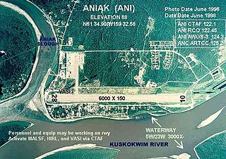
Aniak Airport is a state-owned public-use airport located in Aniak, a city in the Bethel Census Area of the U.S. state of Alaska. Its location on the Kuskokwim River also allows for the landing of seaplanes.
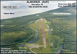
Alakanuk Airport is a state-owned public-use airport located 2 nautical miles (3.7 km) west of the central business district of Alakanuk, a city in the Kusilvak Census Area of the U.S. state of Alaska.
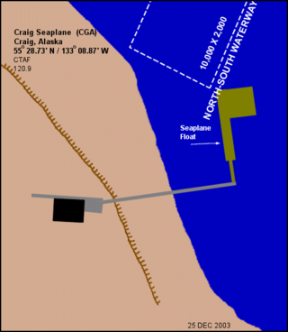
Craig Seaplane Base is a public use seaplane base owned by and located in Craig, a city in the Prince of Wales-Hyder Census Area of the U.S. state of Alaska.
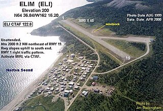
Elim Airport is a state-owned, public-use airport located three nautical miles (6 km) southwest of the central business district of Elim, a city in the Nome Census Area of the U.S. state of Alaska.

Ralph M. Calhoun Memorial Airport is a state-owned public-use airport located one nautical mile (1.85 km) west of the central business district of Tanana, a city in the Yukon-Koyukuk Census Area of the U.S. state of Alaska.

Anaktuvuk Pass Airport is a public use airport located in Anaktuvuk Pass, a city in the North Slope Borough of the U.S. state of Alaska. The airport is owned by North Slope Borough.
Nulato Airport is a state-owned public-use airport located one nautical mile (2 km) northeast of the central business district of Nulato, a city in the Yukon-Koyukuk Census Area of the U.S. state of Alaska.
Old Harbor Airport is a state owned, public use airport located two nautical miles (4 km) northeast of the central business district of Old Harbor, a city in the Kodiak Island Borough in the U.S. state of Alaska.
Ouzinkie Airport is a state-owned public-use airport serving Ouzinkie, a city on Spruce Island in the Kodiak Island Borough of the U.S. state of Alaska.

Port Graham Airport is a state-owned public-use airport located in Port Graham, in the Kenai Peninsula Borough of the U.S. state of Alaska.
Ruby Airport is a state-owned public-use airport located one nautical mile (1.85 km) southeast of the central business district of Ruby, a city in the Yukon-Koyukuk Census Area of the U.S. state of Alaska.
Thorne Bay Seaplane Base is a state-owned public-use seaplane base serving Thorne Bay, a community in the Prince of Wales-Hyder Census Area of the U.S. state of Alaska.
New Stuyahok Airport is a state-owned, public-use airport located one nautical mile (1.85 km) west of the central business district of New Stuyahok, a city in the Dillingham Census Area of the U.S. state of Alaska. Scheduled airline service to Dillingham Airport is provided by Peninsula Airways (PenAir).
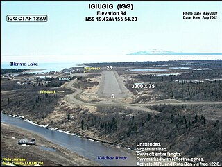
Igiugig Airport is a state-owned, public-use airport serving Igiugig, in the Lake and Peninsula Borough of the U.S. state of Alaska. Scheduled airline service to King Salmon Airport is provided by Peninsula Airways (PenAir).
Nelson Lagoon Airport is a state-owned, public-use airport located one nautical mile (1.85 km) east of the central business district of Nelson Lagoon, in the Aleutians East Borough of the U.S. state of Alaska. Scheduled airline service to Cold Bay Airport is provided by Peninsula Airways (PenAir).

Naknek Airport is a state-owned, public-use airport located one nautical mile north of the central business district of Naknek, in the Bristol Bay Borough of the U.S. state of Alaska.

Hollis Clark Bay Seaplane Base is a state owned, public use seaplane base located one nautical mile (2 km) northeast of the central business district of Hollis, a community in the Prince of Wales-Hyder Census Area in the U.S. state of Alaska. It was formerly known as Hollis Seaplane Base.

Goodnews Airport is a state-owned public-use airport located at Goodnews Bay in the Bethel Census Area of the U.S. state of Alaska.
Pedro Bay Airport is a state-owned public-use airport located one nautical mile (1.85 km) west of the central business district of Pedro Bay, in the Lake and Peninsula Borough of the U.S. state of Alaska.

