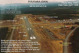
Gulkana Airport is a state owned, public use airport located four nautical miles northeast of the central business district of Gulkana, in the Valdez-Cordova Census Area of the U.S. state of Alaska. It is also and five miles (8 km) northeast of Glenallen. Scheduled passenger service is subsidized by the Essential Air Service program.
Crooked Creek Airport is a public airport located two miles (3 km) south of the central business district of Crooked Creek, in the U.S. state of Alaska.
May Creek Airport is a state owned, public use airport located one nautical mile (2 km) south of the central business district of May Creek, in the Valdez-Cordova Census Area of the U.S. state of Alaska. Scheduled passenger service is subsidized by the Essential Air Service program.
McCarthy Airport is a state owned, public use airport located one nautical mile (2 km) northeast of the central business district of McCarthy, in the Valdez-Cordova Census Area of the U.S. state of Alaska. Scheduled passenger service is subsidized by the Essential Air Service program.

Manokotak Airport is a state-owned public-use airport located one mile (2 km) north of the central business district of Manokotak, a city in the Dillingham Census Area of the U.S. state of Alaska.
Bear Creek 3 Airport is a public-use airport located three nautical miles west of the central business district of Bear Creek, in the Yukon-Koyukuk Census Area of the U.S. state of Alaska. Bear Creek 3 is 40 nautical miles north of McGrath Airport.
Prospect Creek Airport is a state-owned public-use airport located three nautical miles (5.5 km) northeast of Prospect Creek, in the Yukon-Koyukuk Census Area of the U.S. state of Alaska.
Birch Creek Airport is a state-owned, public-use airport located one nautical mile (1.85 km) north-northwest of the central business district of Birch Creek, in the Yukon-Koyukuk Census Area in the U.S. state of Alaska.

Stony River Airport, also known as Stony River 2 Airport, is a state-owned public-use airport located in Stony River, in the Bethel Census Area of the U.S. state of Alaska.
Lake Louise Airport is a state-owned public-use airport located one nautical mile northeast of the central business district of Lake Louise, in the Matanuska-Susitna Borough of the U.S. state of Alaska.
Ophir Airport is a state-owned public-use airport located in Ophir, in the Yukon-Koyukuk Census Area of the U.S. state of Alaska.

Copper Center Airport, also known as Copper Center 2 Airport, is a state-owned public-use airport located one nautical mile south of the central business district of Copper Center, in the Copper River Census Area of the U.S. state of Alaska, United States.
Gold King Creek Airport is a public-use airport located at 64°11′53″N147°55′43″W. It is 39 nautical miles southeast of Fairbanks, Alaska, and is owned by the State of Alaska DOT&PF.
Chandalar Lake Airport is a state-owned public-use airport located at Chandalar Lake in Alaska. This airport is included in the National Plan of Integrated Airport Systems for 2011–2015, which categorized it as a general aviation airport.
Portage Creek Airport is a state-owned public-use airport in Portage Creek, located in the Dillingham Census Area of the U.S. state of Alaska. This airport is included in the FAA's National Plan of Integrated Airport Systems for 2011–2015, which categorized it as a general aviation airport.
Hoonah Seaplane Base is a state-owned public-use seaplane base located in Hoonah, Alaska. It is included in the National Plan of Integrated Airport Systems for 2011–2015, which categorized it as a general aviation facility.
Skagway Seaplane Base is a state-owned public-use seaplane base located in Skagway, Alaska. It is included in the National Plan of Integrated Airport Systems for 2011–2015, which categorized it as a general aviation facility.
Haines Seaplane Base is a public-use seaplane base located in Haines, Alaska. It is owned by Haines Borough. It is included in the National Plan of Integrated Airport Systems for 2011–2015, which categorized it as a general aviation facility.
Dahl Creek Airport is a state owned, public use airport located 10 nautical miles (19 km) southeast of Dahl Creek, in the Northwest Arctic Borough of the U.S. state of Alaska.
Telida Airport is a public use airport located in Telida, in the Yukon-Koyukuk Census Area of the U.S. state of Alaska.
