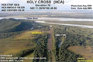
Holy Cross Airport is a state-owned public-use airport located one mile (1.6 km) south of the central business district of Holy Cross, a city in the Yukon-Koyukuk Census Area of the U.S. state of Alaska.
Kalskag Airport is a public airport located one mile (1.6 km) west of the central business district of Upper Kalskag, a city in the Bethel Census Area of the U.S. state of Alaska. The airport is owned by the state. It is situated on the Kuskokwim River, between the cities of Upper Kalskag and Lower Kalskag.

Hageland Aviation Services was a regional FAR Part 135 airline based in Anchorage, Alaska, United States. It operated as the Ravn Connect component of Ravn Alaska, serving many destinations throughout Alaska.

Selawik Airport is a state-owned public-use airport located in Selawik, a city in the Northwest Arctic Borough of the U.S. state of Alaska.

Manokotak Airport is a state-owned public-use airport located one mile (2 km) north of the central business district of Manokotak, a city in the Dillingham Census Area of the U.S. state of Alaska.

Kivalina Airport is a state-owned public-use airport located in Kivalina, a city in the Northwest Arctic Borough of the U.S. state of Alaska.
Koyuk Alfred Adams Airport is a state-owned public-use airport located in Koyuk, a city in the Nome Census Area of the U.S. state of Alaska.
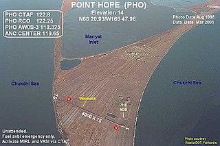
Point Hope Airport is a state-owned public-use airport located two miles (3 km) southwest of the central business district of Point Hope, a city in the North Slope Borough of the U.S. state of Alaska. Point Hope is located in the Lisburne Peninsula, on the Chukchi Sea coast.
Lloyd R. Roundtree Seaplane Facility Seaplane Base is a state-owned public-use seaplane base located in Petersburg, a city in the Petersburg Borough of the U.S. state of Alaska.
Shungnak Airport is a state-owned public-use airport located in Shungnak, a city in the Northwest Arctic of the U.S. state of Alaska.
Wales Airport is a state-owned public-use airport located one nautical mile (2 km) northwest of the central business district of Wales, a city in the Nome Census Area of the U.S. state of Alaska.
Teller Airport is a state-owned public-use airport located two nautical miles (4 km) south of the central business district of Teller, a city in the Nome Census Area of the U.S. state of Alaska.
Stebbins Airport is a state-owned public-use airport located in Stebbins, in the Nome Census Area, Alaska, United States.
St. Michael Airport is a state-owned, public-use airport located two nautical miles (4 km) west of the central business district of St. Michael, a city in the Nome Census Area of the U.S. state of Alaska.

Big Lake Airport is a state-owned public-use airport located one nautical mile (1.8 km) southeast of the central business district of Big Lake, in the Matanuska-Susitna Borough of the U.S. state of Alaska.
Council Airport is a state-owned public-use airport located one nautical mile (1.8 km) north of the central business district of Council, in the Nome Census Area in the U.S. state of Alaska.
Nome City Field is a state-owned public-use airport located one nautical mile north of the central business district of Nome, a city in the Nome Census Area of the U.S. state of Alaska.

Shageluk Airport is a state-owned public-use airport located one nautical mile (1.85 km) north of the central business district of Shageluk, a city in the Yukon-Koyukuk Census Area of the U.S. state of Alaska.
Yankee Creek Airport, also known as Yankee Creek 2 Airport, is a privately owned public-use airport located one nautical mile south of the central business district of Yankee Creek, in the Yukon-Koyukuk Census Area of the U.S. state of Alaska.

