Kivalina Airport

Last updated
Kivalina Airport
Kivalina Alaska aerial view.jpg
Summary
Airport typePublic
Owner State of Alaska DOT&PF - Northern Region
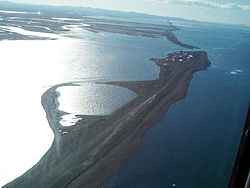
Location Kivalina, Alaska
Elevation  AMSL 13 ft / 4 m
Coordinates 67°44′10″N164°33′49″W / 67.73611°N 164.56361°W / 67.73611; -164.56361
Map
USA Alaska location map.svg
Airplane silhouette.svg
KVL
Location of airport in Alaska
Runways
Direction LengthSurface
ftm
12/303,000914Gravel

Kivalina Airport( IATA : KVL, ICAO : PAVL, FAA LID : KVL) is a state-owned public-use airport located in Kivalina, a city in the Northwest Arctic Borough of the U.S. state of Alaska. [1]

Contents

Facilities

Kivalina Airport has one runway (12/30) with a gravel surface measuring 3,000 x 60 ft. (914 x 18 m). [1]

Airlines and destinations

AirlinesDestinations
Bering Air Kotzebue [2]

Prior to its bankruptcy and cessation of all operations, Ravn Alaska served the airport from multiple locations.

See also

Related Research Articles

Bering Air is an American airline headquartered in Nome, Alaska, United States. It operates domestic scheduled passenger and charter airline services, as well as air ambulance and helicopter services. Its main base is Nome Airport, with hubs at Ralph Wien Memorial Airport (Kotzebue) and Unalakleet Airport.

<span class="mw-page-title-main">Unalakleet Airport</span> Airport

Unalakleet Airport is a state-owned public-use airport located one nautical mile (2 km) north of the central business district of Unalakleet, a city in the Nome Census Area of the U.S. state of Alaska.

<span class="mw-page-title-main">Holy Cross Airport</span> Airport in Holy Cross, Alaska

Holy Cross Airport is a state-owned public-use airport located one mile (1.6 km) south of the central business district of Holy Cross, a city in the Yukon-Koyukuk Census Area of the U.S. state of Alaska.

Kalskag Airport is a public airport located one mile (1.6 km) west of the central business district of Upper Kalskag, a city in the Bethel Census Area of the U.S. state of Alaska. The airport is owned by the state. It is situated on the Kuskokwim River, between the cities of Upper Kalskag and Lower Kalskag.

<span class="mw-page-title-main">Selawik Airport</span> Airport

Selawik Airport is a state-owned public-use airport located in Selawik, a city in the Northwest Arctic Borough of the U.S. state of Alaska.

Kaltag Airport is a state-owned public-use airport located one nautical mile (1.85 km) southwest of the central business district of Kaltag, a city in the Yukon-Koyukuk Census Area of the U.S. state of Alaska.

<span class="mw-page-title-main">Manokotak Airport</span> Airport

Manokotak Airport is a state-owned public-use airport located one mile (2 km) north of the central business district of Manokotak, a city in the Dillingham Census Area of the U.S. state of Alaska.

Koyuk Alfred Adams Airport is a state-owned public-use airport located in Koyuk, a city in the Nome Census Area of the U.S. state of Alaska.

<span class="mw-page-title-main">Bryant Army Heliport</span> Airport in Fort Richardson / Anchorage, Alaska

Bryant Army Airport, also known historically as Bryant Army Airfield, is a U.S. Army Airfield located at Fort Richardson, near the city of Anchorage in the U.S. state of Alaska.

Lloyd R. Roundtree Seaplane Facility Seaplane Base is a state-owned public-use seaplane base located in Petersburg, a city in the Petersburg Borough of the U.S. state of Alaska.

Shungnak Airport is a state-owned public-use airport located in Shungnak, a city in the Northwest Arctic of the U.S. state of Alaska.

Wales Airport is a state-owned public-use airport located one nautical mile (2 km) northwest of the central business district of Wales, a city in the Nome Census Area of the U.S. state of Alaska.

Teller Airport is a state-owned public-use airport located two nautical miles (4 km) south of the central business district of Teller, a city in the Nome Census Area of the U.S. state of Alaska.

Stebbins Airport is a state-owned public-use airport located in Stebbins, in the Nome Census Area, Alaska, United States.

St. Michael Airport is a state-owned, public-use airport located two nautical miles (4 km) west of the central business district of St. Michael, a city in the Nome Census Area of the U.S. state of Alaska.

Port Clarence Coast Guard Station is a private-use airport located one nautical mile (2 km) northeast of the central business district of Port Clarence in the Nome Census Area of the U.S. state of Alaska. It is owned by the U.S. Government.

Nunapitchuk Airport is a state-owned public-use airport located in Nunapitchuk, a city in the Bethel Census Area of the U.S. state of Alaska.

Tuluksak Airport is a state-owned public-use airport serving Tuluksak, in the Bethel Census Area of the U.S. state of Alaska.

Portage Creek Airport is a state-owned public-use airport in Portage Creek, located in the Dillingham Census Area of the U.S. state of Alaska. This airport is included in the FAA's National Plan of Integrated Airport Systems for 2011–2015, which categorized it as a general aviation airport.

References

  1. 1 2 3 FAA Airport Form 5010 for KVL PDF , effective 2007-07-05
  2. Bering Air: Kotzebue Flight Schedule Archived 2014-09-06 at the Wayback Machine (PDF). Retrieved Sep 10, 2022.