
The Ferrymead Railway is a New Zealand heritage railway built upon the track formation of New Zealand's first public railway, from Ferrymead to Christchurch, which opened on 1 December 1863. On the opening of the line to Lyttelton on 9 December 1867, the Ferrymead Railway became the Ferrymead Branch and was closed shortly thereafter. In 1964, rail enthusiasts began relaying track on the historic formation and the new 3 ft 6 in narrow gauge. Ferrymead Railway officially reopened in 1977. It now operates steam, diesel and electric trains regularly and is recognised as one of the most significant rail preservation sites in New Zealand.

William Sefton Moorhouse was a British-born New Zealand politician. He was the second Superintendent of Canterbury Province.
Isaac Luck was a New Zealand architect. A professional builder, he arrived in Lyttelton on the Steadfast in 1851. He was the third chairman of the Christchurch Town Council. He was the brother-in-law of and in partnership with Benjamin Mountfort, and was the less well-known architectural partner for the design of the Canterbury Provincial Council Buildings.
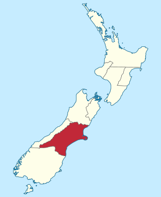
The Canterbury Province was a province of New Zealand from 1853 until the abolition of provincial government in 1876. Its capital was Christchurch.

Christchurch Central City or Christchurch City Centre is the geographical centre and the heart of Christchurch, New Zealand. It is defined as the area within the Four Avenues and thus includes the densely built up central city, some less dense surrounding areas of residential, educational and industrial usage, and green space including Hagley Park, the Christchurch Botanic Gardens and the Barbadoes Street Cemetery.

John Anderson was the second Mayor of Christchurch in New Zealand 1868–1869, and a successful businessman. He had a close connection with three buildings that have later received Category I heritage registrations by Heritage New Zealand. Two of these buildings were demolished following the February 2011 Christchurch earthquake.

Aaron Ayers arrived in Christchurch, New Zealand from England as a newly married man in his mid 20s. He was a hairdresser and tobacconist for two decades before entering the auctioneering business. He was elected Mayor of Christchurch in 1885 unopposed, and was re-elected a year later in the most keenly contested mayoral election thus far, narrowly beating Charles Louisson. He retired after his second term as mayor. In 1887 he contested a 1887 by-election for Heathcote and the 1887 election for Christchurch South, but came second on both occasions. After his mayoralty, he lived mostly a private life and was known as an avid gardener.
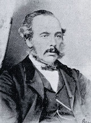
William Thomson was a 19th-century politician from Christchurch, New Zealand, originally from Scotland. He held office at all levels of government, from Parliament and Provincial Council to chairman of a road board. In his professional life, Thomson was an auctioneer, accountant and commission agent. He had rural holdings in Governors Bay and at the Esk River.

Colombo Street is a main road of the city of Christchurch, New Zealand. It runs south-north through the centre of Christchurch with a break at Cathedral Square. As with many other central Christchurch streets, it is named for a colonial Anglican bishopric, Colombo, Sri Lanka in what at the time was known as Ceylon. Parts of the street which run through Sydenham were known as Addison Street during the 1880s, and some parts were known as Colombo Road.

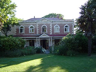
Ohinetahi is a valley, historic homestead, and formal garden on Teddington Road, Governors Bay, Christchurch, Canterbury region, New Zealand. Ohinetahi valley is situated at the head of Lyttelton Harbour, at the base of the Port Hills. While the Ohinetahi Homestead is considered to be a significant historic building in the small settlement of Governors Bay, the formal garden of Ohinetahi is considered to be one of New Zealand's finest. Amongst the early owners of Ohinetahi were Canterbury pioneer William Sefton Moorhouse and Thomas Potts, New Zealand's first conservationist. Sir Miles Warren, architect of the Christchurch Town Hall, was the last private owner, and gifted it to New Zealand.

The Lyttelton Times was the first newspaper in Canterbury, New Zealand, publishing the first edition in January 1851. It was established by the Canterbury Association as part of its planned settlement of Canterbury and developed into a liberal, at the time sometimes seen as radical, newspaper. A successor paper, The Star, is published as a free bi-weekly newspaper.
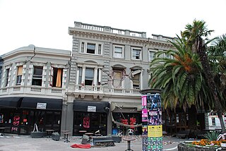
The Excelsior Hotel in 120 Manchester Street, Christchurch, originally the Borough Hotel, in recent years known as Excelsior Backpackers or New Excelsior Backpackers, was a Category I heritage building in central Christchurch. It was designed by then most prominent architect, William Armson, and was one of the few remaining examples of his work in the city. It was heavily damaged in the February 2011 Christchurch earthquake, and all but its western façade was demolished after the earthquakes. The remaining part was demolished in April 2016.
Linwood House was built as the homestead for Joseph Brittan, who, as surgeon, newspaper editor and provincial councillor, was one of the dominant figures in early Christchurch, New Zealand. The suburb of Linwood was named after Brittan's farm and homestead. Brittan's daughter Mary married William Rolleston, and they lived at Linwood House following Joseph Brittan's death. During that time, Rolleston was the 4th Superintendent of the Canterbury Province, and Linwood House served for many important political and public functions.

Joseph Brittan was a New Zealand surgeon, newspaper editor, and provincial councillor, was one of the dominant figures in early Christchurch. Born into a middle-class family in southern England, he followed his younger brother Guise Brittan to Christchurch, where he and his wife arrived in February 1852 with four children. Joseph Brittan soon got involved in the usual activities of early settlers and gained prominence in doing so. He had bought 100 acres on 10 July 1851 and took up 50 of this to the east of Christchurch that he converted to farmland. There, he built the family residence, and the suburb of Linwood was subsequently named after Brittan's farm and homestead of Linwood House.

City Mall is the main pedestrian mall in the central city of Christchurch, New Zealand, comprising two sections of Cashel Street plus the Bridge of Remembrance and one section of High Street. It is also known colloquially as Cashel Mall. The Bridge of Remembrance was pedestrianised in 1976. The main mall was closed to traffic on 11 January 1982 and formally reopened as a pedestrian mall on 7 August, but it was not until 1992 that the entire mall was paved. The mall was redeveloped between 2006 and 2009, and track was installed for an expansion of the heritage tram network.

St Saviour's at Holy Trinity is an Anglican church in Lyttelton, Christchurch, New Zealand. St Saviour's Chapel was relocated from West Lyttelton to Christchurch's Cathedral Grammar School in the 1970s. Following the earthquakes and the demolition of Holy Trinity Church, Lyttelton, St Saviour's was returned to Lyttelton to the site of Holy Trinity in 2013.

Antony Thomas Gough is a New Zealand businessman and property developer based in Christchurch. The grandson of Tracy Thomas Gough, who founded Gough, Gough and Hamer, Gough is considered to be one of the city's most influential businessmen. He is the developer of The Terrace, a major commercial development in Christchurch's retail district and part of the city's reconstruction programme following the 2011 earthquake.

Richard James Strachan Harman was trained as a civil engineer. However, in Christchurch, New Zealand, he worked as a bureaucrat, politician and businessman. He was one of the Canterbury Pilgrims, having arrived in Lyttelton, on Sir George Seymour, one of the First Four Ships. He was a business partner of Edward Cephas John Stevens and senior partner of Harman and Stevens, and together they took financial control of the Christchurch newspaper The Press from its original proprietor, James FitzGerald, over a protracted period. Harman held many important roles with the Canterbury Provincial Council and was the last Deputy-Superintendent.

Whakamana Cannabis Museum is New Zealand's first museum dedicated to the history of cannabis use and culture. It was first opened in October 2013 in Dunedin as part of a project spearheaded by Abe Gray, former deputy leader of the Aotearoa Legalise Cannabis Party (ALCP), and Julian Crawford, former ALCP regional spokesperson.


