This article needs additional citations for verification .(December 2013) |
Shawneeland, Virginia | |
|---|---|
| Coordinates: 39°11′29″N78°20′44″W / 39.19139°N 78.34556°W | |
| Country | United States |
| State | Virginia |
| County | Frederick |
| Area | |
• Total | 7.39 sq mi (19.15 km2) |
| • Land | 7.36 sq mi (19.06 km2) |
| • Water | 0.035 sq mi (0.09 km2) |
| Population (2010) | |
• Total | 1,873 |
| • Density | 255/sq mi (98.3/km2) |
| Time zone | UTC−5 (Eastern (EST)) |
| • Summer (DST) | UTC−4 (EDT) |
| ZIP code | 22602 |
| FIPS code | 51-71625 |
| GNIS feature ID | 2630782 |
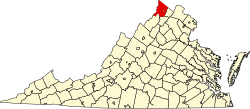
Shawnee Land is a residential community in Frederick County, Virginia, United States. Shawnee Land is located on the eastern slopes of Great North Mountain. The U.S. Census Bureau defines it as a census-designated place (listed as Shawneeland), with a population of 1,873 as of 2010. [1] In its past, Shawnee Land was a ski resort, with a number of slopes located on the eastern side of Great North Mountain. Shawnee Land thrived for a few years, but eventually the investors abandoned the project and the ski slopes were closed.


