Shearer's Covered Bridge | |
|---|---|
 | |
| Coordinates | 40°10′17″N76°23′23″W / 40.1715°N 76.3898°W |
| Locale | Lancaster County, Pennsylvania, United States |
| Characteristics | |
| Design | single span, double Burr arch truss |
| Total length | 89 feet (27.1 m) |
| History | |
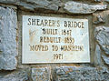
| Constructed by | Jacob Clare |
| Construction start | 1847 |
Shearer's Covered Bridge | |
| MPS | Covered Bridges of Lancaster County TR |
| NRHP reference No. | 80003532 [1] |
| Added to NRHP | December 10, 1980 |
| Location | |
 Interactive map of Shearer's Covered Bridge | |
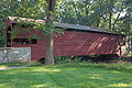
The Shearer's Covered Bridge is a covered bridge that spans the Big Chiques Creek in Lancaster County, Pennsylvania, United States. (Chiques Creek was known as Chickies Creek until 2002). [2]
Contents
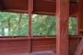
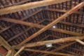
The bridge has a single span, wooden, double Burr arch trusses design. It is the only covered bridge in the county painted entirely in red, the traditional color of Lancaster County covered bridges, on both the inside and outside including both approaches. The other all red bridge, Pool Forge Covered Bridge, is only painted on the outside. It is one of only 3 covered bridges in the county with horizontal side boards.
The bridge's WGCB Number is 38-36-31. Added in 1980, it is listed on the National Register of Historic Places as structure number 80003532. [3] It is located at 40°10′17.4″N76°23′23.4″W / 40.171500°N 76.389833°W (40.17150, -76.38983). [4] [5]