Shiloh, Richland County, Ohio

Last updated

Shiloh, Ohio
Main east of the railroad in Shiloh.jpg
Main Street downtown
OHMap-doton-Shiloh Richland County.png
Location of Shiloh, Richland County, Ohio
Map of Richland County Ohio Highlighting Shiloh Village.png
Location of Shiloh in Richland County
Coordinates: 40°58′10″N82°36′06″W / 40.96944°N 82.60167°W / 40.96944; -82.60167
Country United States
State Ohio
County Richland
Founded1852
Incorporated1874 (village)
Government
   Mayor Timothy W. Wireman[ citation needed ]
Area
[1]
  Total0.92 sq mi (2.38 km2)
  Land0.92 sq mi (2.37 km2)
  Water0.00 sq mi (0.01 km2)
Elevation
[2]
1,083 ft (330 m)
Population
 (2020)
  Total619
  Density675.76/sq mi (260.80/km2)
Time zone UTC-5 (Eastern (EST))
  Summer (DST) UTC-4 (EDT)
ZIP code
44878
Area code 419
FIPS code 39-72298 [3]
GNIS feature ID2399808 [2]
Website Village of Shiloh, Ohio

Shiloh is a village in Richland County in the U.S. state of Ohio. It is part of the Mansfield, Ohio Metropolitan Statistical Area. The population was 619 at the 2020 census.

Contents

History

Shiloh was platted in September 1852 at the junction of the Sandusky and Mansfield Railroad, the Cleveland and Columbus Railroad, and a road between the cities of Tiffin and Wooster. It was originally named "Salem Station" because of its proximity to the village of Salem, which ceased to exist soon after the newer community was founded. In 1862, the name was changed to "Shiloh", but the reasons for the change are unclear: in 1908, some local citizens testified that it was named in honor of the Battle of Shiloh, a Civil War battle fought in 1862, while others stated that it was given in memory of the biblical Shiloh. In 1874, Shiloh was incorporated as a village. [4] Two railroads provided substantial commerce by the end of the century, and natural gas deposits supplied the village with its energy needs and small amounts of gas for export to surrounding communities. [5]

One Shiloh location, the Silas Ferrell House, is listed on the National Register of Historic Places. [6]

Geography

According to the United States Census Bureau, the village has a total area of 0.91 square miles (2.36 km2), all land. [7]

Demographics

Historical population
CensusPop.Note
1870 297
1880 661122.6%
1890 644−2.6%
1900 597−7.3%
1910 555−7.0%
1920 430−22.5%
1930 51419.5%
1940 5191.0%
1950 65526.2%
1960 72410.5%
1970 81712.8%
1980 8574.9%
1990 778−9.2%
2000 721−7.3%
2010 649−10.0%
2020 619−4.6%
Sources: [8] [9]

2010 census

As of the census [10] of 2010, there were 649 people, 235 households, and 170 families living in the village. The population density was 713.2 inhabitants per square mile (275.4/km2). There were 265 housing units at an average density of 291.2 per square mile (112.4/km2). The racial makeup of the village was 97.8% White, 0.6% African American, 0.8% Native American, 0.3% Asian, and 0.5% from two or more races. Hispanic or Latino of any race were 0.5% of the population.

There were 235 households, of which 35.7% had children under the age of 18 living with them, 51.1% were married couples living together, 14.5% had a female householder with no husband present, 6.8% had a male householder with no wife present, and 27.7% were non-families. 20.9% of all households were made up of individuals, and 9% had someone living alone who was 65 years of age or older. The average household size was 2.76 and the average family size was 3.16.

The median age in the village was 38.4 years. 25% of residents were under the age of 18; 10.8% were between the ages of 18 and 24; 25.5% were from 25 to 44; 26.7% were from 45 to 64; and 11.9% were 65 years of age or older. The gender makeup of the village was 49.9% male and 50.1% female.

2000 census

As of the census [3] of 2000, there were 721 people, 246 households, and 200 families living in the village. The population density was 790.9 inhabitants per square mile (305.4/km2). There were 256 housing units at an average density of 280.8 per square mile (108.4/km2). The racial makeup of the village was 98.89% White, 0.28% Native American, 0.28% from other races, and 0.55% from two or more races. Hispanic or Latino of any race were 0.83% of the population.

There were 246 households, out of which 40.2% had children under the age of 18 living with them, 62.2% were married couples living together, 12.2% had a female householder with no husband present, and 18.3% were non-families. 15.9% of all households were made up of individuals, and 5.7% had someone living alone who was 65 years of age or older. The average household size was 2.93 and the average family size was 3.24.

In the village, the population was spread out, with 30.4% under the age of 18, 10.3% from 18 to 24, 28.7% from 25 to 44, 21.2% from 45 to 64, and 9.4% who were 65 years of age or older. The median age was 32 years. For every 100 females there were 97.5 males. For every 100 females age 18 and over, there were 100.0 males.

The median income for a household in the village was $30,750, and the median income for a family was $32,778. Males had a median income of $27,431 versus $20,000 for females. The per capita income for the village was $12,623. About 12.4% of families and 17.3% of the population were below the poverty line, including 26.8% of those under age 18 and 2.4% of those age 65 or over.

Education

Shiloh is located within the Plymouth-Shiloh Local School District. The district administers three public schools in the nearby village of Plymouth including Plymouth-Shiloh Elementary School, Shiloh Middle School, and Plymouth High School. [11]

Related Research Articles

<span class="mw-page-title-main">Richland County, Ohio</span> County in Ohio, United States

Richland County is a county located in the U.S. state of Ohio. As of the 2020 census, the population was 124,936. Its county seat is Mansfield. The county was created in 1808 and later organized in 1813. It is named for the fertile soil found there.

<span class="mw-page-title-main">Richland, Michigan</span> Village in Michigan, United States

Richland is a village in Kalamazoo County in the U.S. state of Michigan. The population was 751 at the 2010 census, up from 593 at the 2000 census.

<span class="mw-page-title-main">Richland, Nebraska</span> Village in Nebraska, United States

Richland is a village in Colfax County, Nebraska, United States. The population was 73 at the 2010 census.

<span class="mw-page-title-main">Sabina, Ohio</span> Village in Ohio, United States

Sabina is a village in Clinton County, Ohio, United States. As of the 2020 census, the village had a total population of 2,499.

<span class="mw-page-title-main">Addyston, Ohio</span> Village in Ohio, United States

Addyston is a village in Miami Township, Hamilton County, Ohio, United States. Located along the Ohio River, it is a western suburb of the neighboring city of Cincinnati. The population was 927 at the 2020 census.

<span class="mw-page-title-main">Cleves, Ohio</span> City in Ohio, United States

Cleves is a village in Miami Township, Hamilton County, Ohio, United States. Located along the Ohio River, it is a western suburb of Cincinnati. The population was 3,414 at the 2020 census.

Shiloh is a census-designated place (CDP) in Harrison Township in Montgomery County, Ohio, United States. It was delineated as a census-designated place at the 2000 census, at which time its population was 11,272. It was not delineated as a CDP at the 2010 census. It is located directly north of the city of Dayton and is part of the Dayton Metropolitan Statistical Area.

<span class="mw-page-title-main">Darbyville, Ohio</span> Village in Ohio, United States

Darbyville is a village in Pickaway County, Ohio, United States. The population was 186 at the 2020 census.

<span class="mw-page-title-main">Bellville, Ohio</span> Village in Ohio, United States

Bellville is a village in Richland County in the U.S. state of Ohio. It is part of the Mansfield, Ohio Metropolitan Statistical Area. The population was 1,963 at the 2020 census.

<span class="mw-page-title-main">Lucas, Ohio</span> Village in Ohio, United States

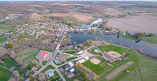
Lucas is a village in southeastern Richland County, Ohio, United States. Lucas is part of the Mansfield, Ohio Metropolitan Statistical Area. The population was 589 at the 2020 census.

<span class="mw-page-title-main">Jerry City, Ohio</span> Village in Ohio, United States

Jerry City is a village in Wood County, Ohio, United States. The population was 454 at the 2020 census.

<span class="mw-page-title-main">Richland, Oregon</span> City in Oregon, United States

Richland is a city in Baker County, Oregon, United States. The population was 156 at the 2010 census.

<span class="mw-page-title-main">Yuba, Wisconsin</span> Village in Wisconsin, United States

Yuba is a village in Richland County, Wisconsin, United States. The population was 74 at the 2010 census. Yuba is 11 miles southwest of Hillsboro and 17 miles north of Richland Center. County Hwy C runs through the village.

<span class="mw-page-title-main">Wilson, Ohio</span> Village in Ohio, United States

Wilson is a village in Belmont and Monroe counties in the U.S. state of Ohio. The population was 129 at the 2020 census. It is part of the Wheeling metropolitan area.

<span class="mw-page-title-main">Crestline, Ohio</span> American village in Crawford and Richland Counties in the U.S. state of Ohio

Crestline is a village in Crawford and Richland Counties in the U.S. state of Ohio. Crestline's population was 4,525 at the 2020 census. It is the third largest municipality in Crawford County. The Crawford County portion of Crestline is part of the Bucyrus Micropolitan Statistical Area, while the small portion of the village that extends into Richland County is considered part of the Mansfield Metropolitan Statistical Area. Both sections form the Mansfield–Bucyrus, OH Combined Statistical Area.

<span class="mw-page-title-main">Plymouth, Ohio</span> Village in Ohio, United States

Plymouth is a village in Huron and Richland counties in the U.S. state of Ohio. The population was 1,707 at the 2020 census.

<span class="mw-page-title-main">Gratiot, Ohio</span> Village in Ohio, United States

Gratiot is a village in Licking and Muskingum counties in the U.S. state of Ohio. The population was 215 at the 2020 census.

<span class="mw-page-title-main">Cazenovia, Wisconsin</span> Village in Wisconsin, United States

Cazenovia is a village in Richland and Sauk Counties in the U.S. state of Wisconsin. The population was 318 at the 2010 census. Of this, 314 were in Richland County, and only 4 were in Sauk County.

<span class="mw-page-title-main">Viola, Wisconsin</span> Village in Wisconsin, United States

Viola is a village in Richland (mostly) and Vernon counties in the U.S. state of Wisconsin. The population was 699 at the 2010 census. Of this, 477 were in Richland County, and 222 were in Vernon County.

<span class="mw-page-title-main">Belle Center, Ohio</span> Village in Ohio, United States

Belle Center is a village in Logan County, Ohio, United States. The population was 809 at the 2020 census. It is a Tree City USA, one of the smallest in the state.

References

  1. "ArcGIS REST Services Directory". United States Census Bureau. Retrieved September 20, 2022.
  2. 1 2 U.S. Geological Survey Geographic Names Information System: Shiloh, Richland County, Ohio
  3. 1 2 "U.S. Census website". United States Census Bureau . Retrieved January 31, 2008.
  4. "About Shiloh". The Village of Shiloh, Ohio. Retrieved December 30, 2013.
  5. Baughman, Abraham J. History of Richland County Ohio from 1808 to 1908. Vol. 1. Chicago: S.J. Clarke, 1908, 422-423.
  6. "National Register Information System". National Register of Historic Places . National Park Service. July 9, 2010.
  7. "US Gazetteer files 2010". United States Census Bureau. Archived from the original on January 25, 2012. Retrieved January 6, 2013.
  8. "Census of Population and Housing". United States Census Bureau . Retrieved December 30, 2013.
  9. Data in historical populations table from US Census, 1890, 1891; US Census, 1920, 1921; US Census, 1950, 1952, ISBN   9780598466846 ; US Census, 1970, 1973; US Census, 2000, ISBN   9781428986060 ; "U.S. Census website". United States Census Bureau . Retrieved December 30, 2013.
  10. "U.S. Census website". United States Census Bureau . Retrieved January 6, 2013.
  11. greatschools. "Plymouth-Shiloh Local School District Profile" . Retrieved December 4, 2013.