The parish lies on the ancient Watling Street, now a lane.
The place is occasionally written simply with the first part of the name, which has been spelt variously over the centuries. Originally "Sibton" (in the Domesday Book of 1086 it was recorded as "Sibetune"), from Saxon origin meaning "Sibba's farmstead". The second part of the full name, Carwood, means "the wood where the rocks are found".[1] The name Carwood is also given to a wooded slope, north of Wart Hill in the north of Hopesay parish, and to three cottages there.
The Norman barons who locally had their power base at Clun Castle, the de Say (or "Sai") family, held the manor after the Norman conquest of England. During the medieval period, the Welsh Marches was an area of instability and conflict, ruled by the Marcher lords. The Domesday Book records Sibdon as having 6 households, making it quite a small manor population-wise.[2]
The fortified manor at Sibdon Carwood, the predecessor to the 17th-century Sibdon Castle country house, is given the name "Shepeton Corbet" by a number of historical documents, including that of John Leland (c. 1535–43), who also gives the suffix to Hopton Castle and Moreton Corbet castle.[3] This is an indication that the Corbet family owned these fortified manors around the time, of which Moreton Corbet's castle retains the suffix to this day.
A description of the parish published in 1848 records that 59 people lived in the parish, which was wholly owned by the Sibdon Castle estate. It also noted a perpetual curacy, with a net income of £50.[4]
The nearby town of Craven Arms is a relatively recent development in the area – it was established only in the mid-19th century, being at the junction of a number of newly-laid railway lines. With much of its recent growth towards the west of the town, its urban area has reached Watling Street and its outskirts fringe into Sibdon Carwood parish.
The hamlet
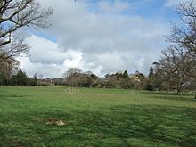
The community is quite dispersed, though there is a core hamlet at the heart of the Sibdon Castleestate. Once the location of a medieval fortification or manor house,[5] the present Sibdon Castle is not a castle but an early/mid-17th century stone country house, built by the Corbet family. It was modernised in the 18th century and made castellated with battlements added around 1800. To the rear of the house is a courtyard with a stone stable block. It is a Grade II* Listed building.[6]
The hamlet at the centre of the Sibdon Castle estate – note the parkland trees
Also within the main hamlet is St Michael's Church, which was rebuilt in 1741; there has been a church here since about 1180. A west tower was added around 1800 and the church was restored, extended and made Gothic, with tower battlements, in 1871–2.[7] The church and a lodge near Sibdon Castle are both Grade II listed.[8][9] Otherwise the hamlet consists of a farm with its own farmhouse, a small number of cottages and numerous outbuildings. Just to the northeast lies Sibdon Pool, a historic 1.3 hectare[10] fishing pool. A private tree-lined carriage drive connects the main hamlet with the Clun Road (the B4368). A number of public right of ways converge on the hamlet, giving the public access to the church, one of which is part of the "Shropshire Way" and "Wart Hill Wanderer".[11]
The eastern border of the parish is Watling Street, a Roman road – the other side of this lane is Craven Arms parish. The northern border is Long Lane, with the parish of Wistanstow to the north, whilst to the west is Hopesay Hill and Common. The parish lies on the eastern slope of the hill, between the summit and the town of Craven Arms (where the River Onny flows through); Sibdon Castle itself is at 187 metres above sea level. The western half of the parish, including the main hamlet, lies within the Shropshire HillsAONB, with the lane running through the parish forming the boundary.[14] This western half of the parish is on a steeper gradient and is more wooded, with Sibdon Wood and Oldfield Wood, as well as parkland style trees.
The parish also includes half of the hamlet of Long Meadowend, which is situated in the southwestern corner of the parish, at the junction of the B4367, B4368 and the main lane through the parish, which runs north to Long Lane. (However the junction at Long Meadowend lies in Hopesay parish.) The B4368 road (running from Craven Arms to Clun) and the Heart of Wales Line run through the southern part of the parish, with the nearest railway stations at Broome and Craven Arms.
A small number of holiday cottages now exist in the parish, on Long Lane and Watling Street. Also on Watling Street a farm has diversified since 2004 into an activities centre for children and groups, which has in recent years created large (temporary) outdoor mazes in nearby fields, including corn mazes.[15] Long Lane is part of the "Six Castles Cycleway" and the National Cycle Network route 44.[16]
Clun is a town in south west Shropshire, England, and the Shropshire Hills Area of Outstanding Natural Beauty. The 2011 census recorded 680 people living in the town. Research by the Campaign for the Protection of Rural England suggests that Clun is one of the most tranquil locations in England.
Craven Arms is a market town and civil parish in Shropshire, England, on the A49 road and the Welsh Marches railway line, which link it north and south to the larger towns of Shrewsbury and Ludlow respectively. The Heart of Wales railway line joins the Welsh Marches line at Craven Arms and the town is served by Craven Arms railway station. The town is enclosed to the north by the Shropshire Hills Area of Outstanding Natural Beauty, and to the south is the fortified manor house of Stokesay Castle.
Shropshire was established during the division of Saxon Mercia into shires in the 10th century. It is first mentioned in 1006. After the Norman Conquest it experienced significant development, following the granting of the principal estates of the county to eminent Normans, such as Roger De Montgomery and his son Robert de Bellême.
Newcastle is a village in the rural south west of Shropshire, England. It lies at the confluence of the River Clun and the Folly Brook, 3 miles west of the small town of Clun. The B4368 runs through the village, on its way between Craven Arms in Shropshire to Newtown in Powys.
Ratlinghope is a hamlet and civil parish in Shropshire, England. The population of the civil parish at the 2011 census was 138. It is situated four miles (6 km) west of Church Stretton and twelve miles (19 km) south of Shrewsbury.
Aston on Clun is a village in south Shropshire, England.
Purslow is a hamlet in south Shropshire, England. It is located on the B4368 between the towns of Clun and Craven Arms, on a minor crossroads.
Clungunford is a village and civil parish in south Shropshire, England, located near the border with Herefordshire.
The Shropshire Hills is a designated Area of Outstanding Natural Beauty (AONB) in Shropshire, England. It is located in the south of the county, extending to its border with Wales. Designated in 1958, the area encompasses 802 square kilometres (310 sq mi) of land primarily in south-west Shropshire, taking its name from the upland region of the Shropshire Hills. The A49 road and Welsh Marches Railway Line bisect the area north–south, passing through or near Shrewsbury, Church Stretton, Craven Arms and Ludlow.
Leintwardine is a small to mid-size village and civil parish in north Herefordshire, England, close to the border with Shropshire.
Stokesay is a village and former civil parish, now in the parish of Craven Arms, in the Shropshire district, in the ceremonial county of Shropshire, England. It is just south of Craven Arms on the A49 road, also fleetingly visible from the Shrewsbury to Hereford Welsh Marches railway line. In 1961 the parish had a population of 1217.
Hopesay is a small village, and civil parish, in south Shropshire, England. The population of the parish at the 2011 census was 561.
Bouldon is a hamlet in Shropshire, England. It lies in the civil parish of Diddlebury.
Halford is a hamlet and former civil parish, now in the parish of Craven Arms, in the Shropshire district, in south Shropshire, England. It lies just east of the market town of Craven Arms, on the other side of the River Onny. In 1961 the parish had a population of 167.
Cheney Longville is a small village in Shropshire, England.
National Cycle Network Route 44, part of the National Cycle Network, connects Shrewsbury, Shropshire with Cinderford, Gloucestershire. The part of the route from Shrewsbury to Bromfield is signed - the remainder of the route is currently unsigned.
Munslow is a small village and civil parish in Shropshire, England. It is situated on the B4368, 7 miles (11 km) northeast of the small town of Craven Arms, in the Corvedale, at around 140 metres (460 ft) above sea level.
Little Brampton is a hamlet in south Shropshire, England.
The Corbet family is an aristocratic English family of Anglo-Norman extraction, who were amongst the early marcher lords, holding the barony of Caus. Following the extinction of the senior line the junior line based at Moreton Corbet Castle would go on to becaome one of the most powerful and richest of the landed gentry in Shropshire. The family trace their ancestry to two barons found in the 1086 Domesday Book and they probably came from the Boitron and Essay region, near Sées in Normandy. The name Corbet derives from the Anglo-Norman word corb, meaning "crow" or "raven", matching the modern French corbeau. Variants of the name include: Corbet, Corbett, Corbitt, Corbit, Corbetts, Corbete, Corben and possibly the variant of Corbin. The underlying derivation is from the Latin word corvus, crow. Generally it is thought to be a jocular reference to a person who was thought to resemble a crow or raven: in hair colour, tone of voice or shape of nose. However, the Scandinavians believed that a raven on the battlefield was a beneficial omen and ensured victory.
This page is based on this Wikipedia article Text is available under the CC BY-SA 4.0 license; additional terms may apply. Images, videos and audio are available under their respective licenses.


