
Luray is the county seat of Page County, Virginia, United States, in the Shenandoah Valley in the northern part of the commonwealth. The population was 4,895 at the 2010 census.

Mount Jackson is a town in Shenandoah County, Virginia, United States. The population was 1,994 at the 2010 census.

Marine Corps Base Quantico is a United States Marine Corps installation located near Triangle, Virginia, covering nearly 55,148 acres (86.169 sq mi) of southern Prince William County, Virginia, northern Stafford County, and southeastern Fauquier County. Used primarily for training purposes, MCB Quantico is known as the "Crossroads of the Marine Corps".

The Appomattox Court House National Historical Park is a preserved 19th-century village in Appomattox County, Virginia. The village is famous for the site of the Battle of Appomattox Court House, and contains the house of Wilmer McLean, where the surrender of the Army of Northern Virginia under Robert E. Lee to Union commander Ulysses S. Grant took place on April 9, 1865, effectively ending the American Civil War. The McLean House was the site of the surrender conference, but the village itself is named for the presence nearby of what is now preserved as the Old Appomattox Court House.
Signal Hill may refer to:
Bennett Place, Durham, North Carolina, was the site of the last surrender of a major Confederate army in the American Civil War, when Joseph E. Johnston surrendered to William T. Sherman. The first meeting saw Sherman agreeing to certain political demands by the Confederates, which were promptly rejected by the Union cabinet in Washington. Another meeting had to be held to agree on military terms only, in line with Robert E. Lee’s recent surrender to Ulysses S. Grant. This effectively ended the war.

Petersburg National Battlefield is a National Park Service unit preserving sites related to the American Civil War Siege of Petersburg (1864–65). The Battlefield is centered on the city of Petersburg, Virginia, and also includes outlying components in Hopewell, Prince George County, and Dinwiddie County. Over 140,000 people visit the park annually.

Manassas National Battlefield Park is a unit of the National Park Service located in Prince William County, Virginia, north of Manassas that preserves the site of two major American Civil War battles: the First Battle of Bull Run, also called the First Battle of Manassas, and the Second Battle of Bull Run or Second Battle of Manassas. It was also where Confederate General Thomas J. Jackson acquired his nickname "Stonewall". The park was established in 1940 and listed on the National Register of Historic Places on October 15, 1966.

Buildings, sites, districts, and objects in Virginia listed on the National Register of Historic Places:

Leesylvania State Park is located in the southeastern part of Prince William County, Virginia. The land was donated in 1978 by philanthropist Daniel K. Ludwig, and the park was dedicated in 1985 and opened full-time in 1992.

Sayler's Creek Battlefield near Farmville, Virginia was the site of the Battle of Sayler's Creek of the American Civil War. Robert E. Lee's army was retreating from the Richmond to Petersburg line. Here, on April 6, 1865, Union General Philip Sheridan cut off and beat back about a quarter of Lee's army. Eight Confederate generals surrendered, and 7,700 men were lost. Confederate Major General George Washington Custis Lee, eldest son of Robert E. Lee, was forcibly captured on the battlefield by Private David Dunnels White of the 37th Massachusetts Regiment. This was the last major engagement of the war in Virginia; Lee's surrender at Appomattox occurred three days later. A portion of the landmarked battlefield area is included in Sailor's Creek Battlefield Historical State Park. The Civil War Trust and its partners have acquired and preserved 885 acres (3.58 km2) of the battlefield in five transactions since 1996.

Staunton River Battlefield State Park is a state park located in Virginia. The park straddles the Staunton River in Halifax and Charlotte counties. The Roanoke visitor center in Randolph, Virginia is a railroad depot which now holds exhibits on Native Americans and railroad history. The Clover visitor center has exhibits on the American Civil War and the battle which took place on this site. It also includes information about the production of electric energy. The park also includes the Mulberry Hill plantation, given to the state in 1999.

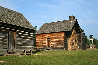
The McLean House near Appomattox, Virginia is within the Appomattox Court House National Historical Park. The house was owned by Wilmer McLean and his wife Virginia near the end of the American Civil War. It served as the location of the surrender of the Confederate army of General Robert E. Lee on April 9, 1865, after a nearby battle.

This is a list of the National Register of Historic Places listings in Prince William County, Virginia.

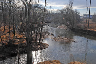
The Orange and Alexandria Railroad Bridge Piers are the historical remains of a bridge that carried the Orange and Alexandria Railroad across Bull Run between Fairfax and Prince William Counties, Virginia. The railroad, and this bridge location in particular, were of strategic interest to both Union and Confederate forces during the American Civil War. The bridge was rebuilt at least seven times during the war years. The piers are located just south of a modern railroad bridge.

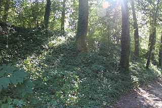
The Mayfield Fortification is a historic American Civil War earthworks at 8401 Quarry Road in Manassas, Virginia. It is one of a series of fortifications constructed by the Confederate Army to defend the critical Manassas railroad junction in 1861. The fort consisted of earthworks with log revetments, and was built by local Confederate troops and slave labor. After 1862 the fort was sporadically occupied by Union forces.
Fort Boykin is a historic site in Isle of Wight County, Virginia, located along the James River. The history of the site is believed to date back to 1623 when colonists were ordered to build a fort to protect them from attacking Native Americans or Spanish marauders. Today the remains of the fort, mostly from the American Civil War, are preserved in a public park.
The Rising Hill Camp is an historic Confederate Army encampment, now located on the grounds of the Marine Corps Base Quantico in Prince William County, Virginia. The 1.7-acre (0.69 ha) site is believed to have been used by the 47th Virginia and 22nd North Carolina Regiments in connection with the operation of a battery at the top of a rise that was labeled "Rising Hill" on Union maps. The site consists rows of hut pits, at least 86 in number, arrayed down the western slope of a ridge. Although test pits have been dug by archaeologists, the site has not been investigated in detail.
The Mitchell's Ford Entrenchments are the remains of a Confederate Army defensive earthworks in Prince William County, Virginia. They are located off Old Centreville Road, overlooking what was historically called Mitchell's Ford, roughly where Old Centreville Road crosses Bull Run. These earthworks were occupied by Confederate troops defending the ford during the 1861 battles of Blackburn's Ford and First Bull Run. The area is now a local park managed by the local homeowner's association.


