Sathyamangalam is a town and municipality in Erode district in the Indian state of Tamil Nadu. 8 th century Town. It lies on the banks of the River Bhavani, a tributary of the River Cauvery in the foothills of the Western Ghats. It is about 65 km from Erode, 58 km from Tiruppur and 70 km from Coimbatore. As of 2011, the town had a population of 37,816.

Dharmapuri is a city in the north western part of Tamil Nadu, India. It serves as the administrative headquarters of Dharmapuri district which is the first district created in Tamil Nadu after the independence of India by splitting it from then Salem district on 2 October 1965. The city is located at 50 km from Krishnagiri, 69 km from Salem, 90 km from Hosur, 117 km from Thiruvannamalai, 126 km from Bangalore and Erode, 181 km from Tiruppur, 200 km from Coimbatore and Tiruchirappalli, 300 km from Madurai and the state capital Chennai. It is located between latitudes N 11 47’ and 12 33’ and longitudes E 77 02’ and 78 40’. It is one of the leading major cultivator and producer of mango in the state along with Krishnagiri often referred as Mango Capital of India.

Dharmapuri is one of the 38 districts in the state of Tamil-Nadu, India. It is the first district created in Tamil Nadu after the independence of India by splitting it from then-Salem district on 2 October 1965. Dharmapuri District is one of the major producers of mango in the state, fine quality granite is found in the district. It is also one of the main sericulture belts in the state. Around 30 percent of the district's area is under forest cover. Kaveri enters Tamil Nadu through this district. Dharmapuri district had the lowest literacy rate of 74.23% in Tamilnadu during the 2011 census.

Dharapuram is a town situated along the banks of Amaravati River in Tiruppur district in the Indian state of Tamil Nadu. Dharapuram is one of the oldest towns in South India and was the capital of Kongu Nadu under the Cheras, Western Ganga Dynasty and later Kongu Cholas, at which time it was known as Viradapuram. Amaravathi River flows through the town. As of 2011, the town had a population of 67,007. The city houses famous temples including Agatheeswarar Temple, Kaadu Hanumanthasamy temple and many others.
Irugur is a suburb of Coimbatore city in the state of Tamil Nadu. It is one of the fastest developing suburbs in the Coimbatore Metropolitan Area. It is located to the north of Trichy Road which is a part of National Highway National Highway 81.
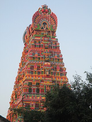
Karamadai is town located near Mettupalayam, in the Indian state of Tamil Nadu. It is located on Coimbatore - Ooty NH 67. Nearby places are Teachers colony, Press Colony, Jodhipuram and Periyanaickenpalayam. The Ranganathaswamy temple and Nanjundeswarar temple are the most prominent landmarks in the town. The place of Karamadai came into limelight due to the presence of ex-steel giant Sri Ramakrishna Steel Industries.
Kinathukadavu, meaning Pass of the Well, is a town panchayat suburb of Coimbatore city and taluk in Coimbatore district in the Indian state of Tamil Nadu. It is along the National Highway 209 and is 23 kilometres (14 mi) from Gandhipuram heart of Coimbatore city and 20.5 kilometres (13 mi) from Pollachi town.
Mecheri is a town in Mettur taluk, Salem district, Tamil Nadu, India.
Mettupalayam is a municipality town and taluk headquarters of Mettupalayam Taluk in the Coimbatore district of the Indian state of Tamil Nadu. It is the third largest town in the Coimbatore district after Coimbatore and Pollachi. It's located to the North of the Coimbatore city on the way to Ooty in the foothills of Nilgiri hills. As of 2011, the town had a population of 66,595. Mettupalayam railway station is the starting point of Nilgiri Mountain Railway and it operates the only rack railway in India connecting Ooty and Mettupalayam.
Nallur (Nalloor) is a panchayat town in Kanniyakumari district in the Indian state of Tamil Nadu.
Sathankulam is a panchayat town in Thoothukudi district in the Indian state of Tamil Nadu.
Thirumalayampalayam is a panchayat town in Coimbatore district in the Indian state of Tamil Nadu. It is an important suburb of Coimbatore.
Veerapandi is a panchayat town in Coimbatore district in the Indian state of Tamil Nadu.
Vellakovil is a municipal town in Kangeyam taluk of Tirupur District, in the Indian state of Tamil Nadu. It is located on National Highway 81 between Trichy and Coimbatore. The town is spread in an area of 64.75 km2. As of 2011, the town had a population of 40,359. Kannapuram village located near to this town is famous for Kangeyam breed cattle market that happens on every year during Mariyamman temple festival in the month of April. It is an industrialized town with traditional agriculture being the occupation for most of the people. It holds lot of Power looms weaving bedsheets, floor mats and cotton materials being exported to foreign countries via exporters present in Karur.
Pallapalayam is a Town panchayat in Coimbatore district in the Indian state of Tamil Nadu.
Vellakinar is one of the localities of the Coimbatore city in Tamil Nadu, India. Vellakinar is located on the stretch of Mettupalayam road in Coimbatore. Neighbourhing places of Vellakinar are Thudiyalur, Goundampalayam, GN Mills(Gnanambikai Mills). Tamil Nadu Housing Board colony, Sreevatsa Gardens, Samathuvapuram and Meenakshi Gardens, Coimbatore are main residential areas in Vellakinar panchayat. Vellakinar was added to the Coimbatore municipal corporation.
Edappadi is a taluk of Salem district in the Indian state of Tamil Nadu. The administrative centre is the town of Edappadi. The taluk contains two panchayat towns, Konganapuram and Poolampatti, and ten panchayat villages. The Edappadi revenue block is coterminous with the taluk.
Malumichampatti is a residential village in the Coimbatore-South taluk, Coimbatore district, Tamil Nadu, India. It is along the National Highway 209. It is a village panchayat and belongs to Kinathukadavu Legislative constituency.
The Coimbatore Metropolitan Area, or Coimbatore Urban Agglomeration, is the sixteenth-most populous metropolitan area in India, the second most populous metropolitan area in the state of Tamil Nadu next only to Chennai. The Coimbatore Metropolitan Area consists of the city of Coimbatore and its suburbs in Coimbatore district.
Bogampatti is village and gram panchayat located in Sulur Taluk of Coimbatore district in the Indian state of Tamil Nadu. The panchayat falls under the Sulur state assembly constituency and the Coimbatore Lok Sabha constituency. The panchayat has a total of 7 panchayat constituencies. Out of these, 7 panchayat members are elected. According to the 2011 Census of India, the total population is 1,772. Of these, 880 are women and 892 are men. The village has a presence in wind power generation in India. The Tamil Nadu branch office of the leading wind turbine company is located here.


