Departure Lake is a dispersed rural community and unincorporated place in geographic Haggart Township, Cochrane District in Northeastern Ontario, Canada. It is located on Ontario Highway 11 between the communities of Strickland to the west and Smooth Rock Falls to the east.

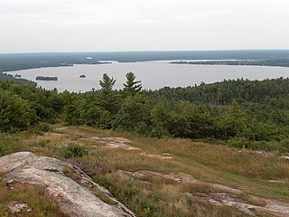
Rib Lake is a long and narrow lake in the Town of Latchford and in the Municipality of Temagami in Northeastern Ontario, Canada, located about 9 kilometres (6 mi) southeast of the centre of the community of Latchford and 9 kilometres (6 mi) northeast of the community of Temagami North. The lake is in the Ottawa River drainage basin and is the main access for canoeists en route to Rib Mountain.
Bull Lake is a lake in geographic Devonshire Township in the municipality of Sioux Narrows-Nestor Falls, Kenora District, Ontario, Canada. It is about 570 metres (1,870 ft) long and 260 metres (853 ft) wide, and lies at an elevation of 358 metres (1,175 ft) about 15 kilometres (9.3 mi) northeast of the community of Sioux Narrows. The primary outflow is an unnamed creek to Mac Lake, whose waters flow via the Black River into Lake of the Woods.

The Blanche River is a river in the Saint Lawrence River drainage basin in Timiskaming District in northeastern Ontario, Canada. The river is a tributary of Lake Timiskaming and its name is from the French for the colour "white".
Calabogie Lake is a reservoir lake in the municipality of Greater Madawaska, Renfrew County in Eastern Ontario, Canada. It is on the Madawaska River system, is part of the Saint Lawrence River drainage basin, and is located in the geographic townships of Bagot Township and Blythfield Township.
Sixteen Mile Creek is a stream in the municipalities of Lincoln, Pelham and West Lincoln, Regional Municipality of Niagara in Southern Ontario, Canada. It is part of the Great Lakes Basin and flows from the top of the Niagara Escarpment to Sixteen Mile Pond on Lake Ontario. The stream falls within the remit of the Niagara Peninsula Conservation Authority, whose 2012 watershed report card gave the stream watershed grades of D for both water quality and forest cover.
Sixteen Mile Creek is a stream in the municipality of Lake of Bays, District Municipality of Muskoka in Central Ontario, Canada. It is part of the Great Lakes Basin and flows from Hickory Lake to its mouth at the Boyne River. The Boyne River flows to the Lake of Bays, then via the Muskoka River, and the Moon River and Musquash River to Georgian Bay on Lake Huron.
The Boyne River is a river in the municipality of Lake of Bays, District Municipality of Muskoka in Central Ontario, Canada. It is part of the Great Lakes Basin, and flows from Fowler Lake to its mouth at Dwight Bay on the Lake of Bays near the community of Dwight on Ontario Highway 60. The Lake of Bays flows via the Muskoka River, then the Moon River and Musquash River to Georgian Bay on Lake Huron.

The Boyne River is a river in the municipality of Grey Highlands, Grey County in Southwestern Ontario, Canada. It is part of the Great Lakes Basin, and lies entirely within geographic Artemesia Township.
The Boyne River is a river in Simcoe County and Dufferin County in Central Ontario, Canada. It is part of the Great Lakes Basin, and is a left tributary of the Nottawasaga River. The rivers falls within the jurisdiction of the Nottawasaga Valley Conservation Authority.

The Beaver River is a river in Grey County and Simcoe County in Southern Ontario, Canada. It is part of the Great Lakes Basin, and is a tributary of Lake Huron. The river's drainage basin is under the auspices of Grey Sauble Conservation.

The Beaver River is a river in Durham Region in Central Ontario, Canada. It is part of the Great Lakes Basin, and is a tributary of Lake Simcoe. The river's drainage basin is mostly in Durham Region with the remaining portion in the city of Kawartha Lakes; the entire watershed is under the auspices of the Lake Simcoe Region Conservation Authority.

The Black River is a river in Hastings County in Central Ontario, Canada. It is part of the Great Lakes Basin, and is a left tributary of the Moira River.

The Black River is a river in Cochrane District and Timiskaming District in Northeastern Ontario, Canada. It is part of the James Bay drainage basin, and is a right tributary of the Abitibi River. The municipality of Black River-Matheson is named after the river.
The Black River is a river in Simcoe County, the District Municipality of Muskoka, the City of Kawartha Lakes, and Haliburton County in Central Ontario, Canada. It is part of the Great Lakes Basin, and is a right tributary of the Severn River.
Salem Creek is a stream in the municipal township of Cramahe, Northhumberland County in Central Ontario, Canada. It is a tributary of Lake Ontario. The creek takes its name from the community of Salem which it flows past.
The Poplar Rapids River is a river in the municipality of Fauquier-Strickland and Unorganized North Cochrane District, Cochrane District in Northeastern Ontario, Canada. It is in the James Bay drainage basin and is a left tributary of the Mattagami River.
McKenzie Lake is a lake in geographic Speight Township in the Unorganized West Part of Timiskaming District in northeastern Ontario, Canada. It is part of the Saint Lawrence River drainage basin, and is about 20 kilometres (12 mi) southwest of the community of Kenabeek.
Harebell Lake is a lake in geographic Speight Township in the Unorganized West Part of Timiskaming District in northeastern Ontario, Canada. It is part of the Saint Lawrence River drainage basin, and is about 22 kilometres (14 mi) southwest of the community of Kenabeek.
Port Granby Creek is a stream in the municipality of Clarington, Regional Municipality of Durham in Ontario, Canada. It feeds into Lake Ontario, which it reaches at the community of Port Granby, after which it is named.
