South Rockwood, Michigan

Last updated

South Rockwood, Michigan
South Rockwood, MI village hall.jpg
South Rockwood Village Hall
South Rockwood, MI location 2020.png
Location within Monroe County and the state of Michigan
USA Michigan location map.svg
Red pog.svg
South Rockwood
Usa edcp location map.svg
Red pog.svg
South Rockwood
Coordinates: 42°03′50″N83°15′40″W / 42.06389°N 83.26111°W / 42.06389; -83.26111
CountryUnited States
State Michigan
County Monroe
Township Berlin
Founded1863
Incorporated1955
Government
[1]
  Type Village council
  PresidentCharles Horn
   Clerk Angela Hightower
Area
[2]
  Total3.33 sq mi (8.62 km2)
  Land3.27 sq mi (8.47 km2)
  Water0.06 sq mi (0.16 km2)
Elevation
587 ft (179 m)
Population
 (2020) [3]
  Total1,587
  Density484.58/sq mi (187.11/km2)
Time zone UTC-5 (Eastern (EST))
  Summer (DST) UTC-4 (EDT)
ZIP Code
48179
Area code 734
FIPS code 26-75280 [4]
GNIS feature ID0638409 [5]
Website villageofsouthrockwoodmi.com

South Rockwood is a village in Monroe County in the U.S. state of Michigan. The population was 1,587 at the 2020 census. [3] The village is located within Berlin Charter Township.

Contents

History

South Rockwood was founded in 1863 by John Strong, who named the community after Rockwood, Ontario. The nearby community of Rockwood was located just to the north and had been settled a few years earlier. Strong established the South Rockwood post office on July 5, 1877. South Rockwood incorporated as a village in 1955. [6]

Geography

South Rockwood is in the northeast corner of Monroe County, in the northern part of Berlin Charter Township. The Huron River forms the northern boundary of the village and county line with the city of Rockwood in Wayne County.

According to the U.S. Census Bureau, the village has a total area of 3.33 square miles (8.62 km2), of which 3.27 square miles (8.47 km2) are land and 0.06 square miles (0.16 km2) (1.80%) are water. [2]

Major highways

Demographics

Historical population
CensusPop.Note
1880 251
1960 1,337
1970 1,47710.5%
1980 1,353−8.4%
1990 1,221−9.8%
2000 1,2845.2%
2010 1,67530.5%
2020 1,587−5.3%
U.S. Decennial Census [7]

2010 census

As of the census [8] of 2010, there were 1,675 people, 687 households, and 453 families living in the village. The population density was 712.8 inhabitants per square mile (275.2/km2). There were 734 housing units at an average density of 312.3 per square mile (120.6/km2). The racial makeup of the village was 95.4% White, 2.3% African American, 0.2% Native American, 0.4% Asian, 0.4% from other races, and 1.3% from two or more races. Hispanic or Latino of any race were 4.1% of the population.

There were 687 households, of which 30.0% had children under the age of 18 living with them, 50.4% were married couples living together, 11.5% had a female householder with no husband present, 4.1% had a male householder with no wife present, and 34.1% were non-families. 25.6% of all households were made up of individuals, and 6.2% had someone living alone who was 65 years of age or older. The average household size was 2.44 and the average family size was 2.95.

The median age in the village was 38.9 years. 20.8% of residents were under the age of 18; 8.9% were between the ages of 18 and 24; 29% were from 25 to 44; 31.1% were from 45 to 64; and 10.1% were 65 years of age or older. The gender makeup of the village was 50.7% male and 49.3% female.

2000 census

As of the census [4] of 2000, there were 1,284 people, 450 households, and 359 families living in the village. The population density was 526.1 inhabitants per square mile (203.1/km2). There were 464 housing units at an average density of 190.1 per square mile (73.4/km2). The racial makeup of the village was 97.59% White, 0.23% African American, 0.23% Native American, 0.08% Asian, 0.08% from other races, and 1.79% from two or more races. Hispanic or Latino of any race were 0.78% of the population.

There were 450 households, out of which 37.3% had children under the age of 18 living with them, 66.9% were married couples living together, 8.9% had a female householder with no husband present, and 20.2% were non-families. 14.9% of all households were made up of individuals, and 5.8% had someone living alone who was 65 years of age or older. The average household size was 2.85 and the average family size was 3.18.

In the village, the population was spread out, with 26.6% under the age of 18, 9.0% from 18 to 24, 29.0% from 25 to 44, 26.3% from 45 to 64, and 9.0% who were 65 years of age or older. The median age was 37 years. For every 100 females, there were 109.8 males. For every 100 females age 18 and over, there were 102.6 males.

The median income for a household in the village was $62,500, and the median income for a family was $68,304. Males had a median income of $50,882 versus $27,813 for females. The per capita income for the village was $22,245. About 2.3% of families and 4.1% of the population were below the poverty line, including 2.9% of those under age 18 and 4.8% of those age 65 or over.

Education

The village is served by Airport Community Schools. [9]

Related Research Articles

<span class="mw-page-title-main">Rockwood, Illinois</span> Village in Illinois, United States

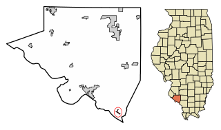
Rockwood is a village in Randolph County, Illinois, United States. The population was 32 at the 2020 census. It is the headquarters of the Middle Mississippi River National Wildlife Refuge.

<span class="mw-page-title-main">Bellaire, Michigan</span> Village in Michigan, United States

Bellaire is a village and the county seat of Antrim County, Michigan. The population was 1,053 in 2020 census.

<span class="mw-page-title-main">Edwardsburg, Michigan</span> Village in Michigan, United States

Edwardsburg is a village within Ontwa Township in Cass County in the U.S. state of Michigan, northeast of South Bend. The population was 1,259 at the 2010 census. It is part of the South Bend–Mishawaka, IN-MI, Metropolitan Statistical Area.

<span class="mw-page-title-main">Ashley, Michigan</span> Village in Michigan, United States

Ashley is a village in Gratiot County in the U.S. state of Michigan. The population was 508 at the 2020 census. The village is located in the northwest corner of Elba Township. No major state trunkline runs through the village, although M-57 passes within one mile to the south. Ashley was platted in 1884.

<span class="mw-page-title-main">Ash Township, Michigan</span> Civil township in Michigan, United States

Ash Township is a civil township of Monroe County in the U.S. state of Michigan. As of the 2020 census, the township population was 7,860.

<span class="mw-page-title-main">Berlin Charter Township, Michigan</span> Charter township in Michigan, United States

Berlin Charter Township is a charter township of Monroe County in the U.S. state of Michigan. At the 2020 census, the township population was 9,890.

<span class="mw-page-title-main">Carleton, Michigan</span> Village in Michigan, United States

Carleton is a village in Monroe County in the U.S. state of Michigan. The population was 2,326 at the 2020 census. The village is located within Ash Township.

<span class="mw-page-title-main">Dundee, Michigan</span> Village in Michigan, United States

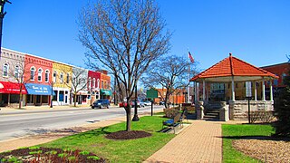
Dundee is a village in Monroe County in the U.S. state of Michigan. The population was 5,323 at the 2020 census, up from 3,957 in 2010. The village is within Dundee Township and is served by Dundee Community Schools.

<span class="mw-page-title-main">Dundee Township, Michigan</span> Civil township in Michigan, United States

Dundee Township is a civil township of Monroe County in the U.S. state of Michigan. The population was 8,145 at the 2020 census, up from 6,759 in 2010. The township contains the village of Dundee, and the majority of the township is served by Dundee Community Schools.

<span class="mw-page-title-main">Estral Beach, Michigan</span> Village in Michigan, United States

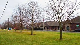
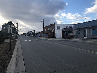
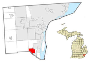
Estral Beach is a village in Monroe County in the U.S. state of Michigan. The population was 403 at the 2020 census. The village is located within Berlin Charter Township.
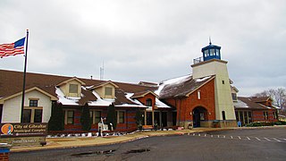
<span class="mw-page-title-main">South Monroe, Michigan</span> Census-designated place & unincorporated community in Michigan, United States

South Monroe is an unincorporated community and census-designated place (CDP) in Monroe County in the U.S. state of Michigan. The population was 6,468 at the 2020 census. The CDP is located within Monroe Charter Township.

Monroe Township is a civil township of Newaygo County in the U.S. state of Michigan. As of the 2000 census, the township population was 324.

<span class="mw-page-title-main">Breedsville, Michigan</span> Village in Michigan, United States

Breedsville is a village in Van Buren County of the U.S. state of Michigan. The population was 199 at the 2010 census. The village is within Columbia Township.

<span class="mw-page-title-main">Flat Rock, Michigan</span> City in Michigan, United States

Flat Rock is a city in Wayne County, Michigan, United States, with a small portion of the city extending into Monroe County. At the 2020 census, the population was 10,541.

<span class="mw-page-title-main">Rockwood, Michigan</span> City in Michigan, United States

Rockwood is a city in southeastern Wayne County in the U.S. state of Michigan. The population was 3,289 at the 2010 census.

<span class="mw-page-title-main">Buckley, Michigan</span> Village in Michigan, United States

Buckley is a village in Wexford County in the U.S. state of Michigan. The population was 775 at the 2020 census, an increase from 697 at the 2010 census. The village is located within Hanover Township, and lies immediately south of the Grand Traverse County line. The village lies about 6.5 miles (10.5 km) north of Mesick, about 20 miles (32 km) northwest of Cadillac, and about 15 miles (24 km) south of Traverse City.

<span class="mw-page-title-main">Stoutsville, Missouri</span> Village in Missouri, United States

Stoutsville is a village in Monroe County, Missouri, United States. The population was 37 at the 2020 census.

<span class="mw-page-title-main">Wildwood, Missouri</span> City in Missouri, United States

Wildwood is a city in St. Louis County, Missouri, United States. It is located in the far western portion of the county. As of the 2020 census, the population was 35,417. Wildwood is the home of the Al Foster Trail, and numerous other trails, parks, and reserves such as Rockwoods Reservation and Babler State Park.

<span class="mw-page-title-main">Casnovia, Michigan</span> Village in Michigan, United States

Casnovia is a village in the U.S. state of Michigan. It is situated on the boundary between Muskegon and Kent counties and lies partially within each. The population was 316 at the 2020 census.

<span class="mw-page-title-main">Summerfield Township, Monroe County, Michigan</span> Civil township in Michigan, United States

Summerfield Township is a civil township of Monroe County in the U.S. state of Michigan. The population was 3,176 at the 2020 census.

References

  1. Village of South Rockwood (2020). "Village Officials" . Retrieved April 2, 2020.
  2. 1 2 "2023 U.S. Gazetteer Files: Michigan". United States Census Bureau. Retrieved November 1, 2023.
  3. 1 2 "P1. Race – South Rockwood village, Michigan: 2020 DEC Redistricting Data (PL 94-171)". U.S. Census Bureau. Retrieved November 1, 2023.
  4. 1 2 "U.S. Census website". United States Census Bureau . Retrieved January 31, 2008.
  5. "US Board on Geographic Names". United States Geological Survey. October 25, 2007. Retrieved January 31, 2008.
  6. Romig, Walter (October 1, 1986) [1973]. Michigan Place Names: The History of the Founding and the Naming of More Than Five Thousand Past and Present Michigan Communities (Paperback). Great Lakes Books Series. Detroit, Michigan: Wayne State University Press. p. 527. ISBN   978-0-8143-1838-6.
  7. "Census of Population and Housing". Census.gov. Retrieved June 4, 2015.
  8. "U.S. Census website". United States Census Bureau . Retrieved November 25, 2012.
  9. Michigan Geographic Framework (November 15, 2013). "Monroe County School Districts" (PDF). Archived (PDF) from the original on August 21, 2014. Retrieved October 28, 2021.