Estral Beach, Michigan

Last updated

Estral Beach, Michigan
Estral Beach Village Hall, MI.jpg
Fire department and village hall
Estral Beach, MI location 2020.png
Location within Monroe County and the state of Michigan
USA Michigan location map.svg
Red pog.svg
Estral Beach
Usa edcp location map.svg
Red pog.svg
Estral Beach
Coordinates: 41°59′03″N83°14′09″W / 41.98417°N 83.23583°W / 41.98417; -83.23583
CountryUnited States
State Michigan
County Monroe
Township Berlin
Incorporated1925
Government
  Type Village council
  PresidentFred Borowski
   Clerk Carol Vandercook
Area
[1]
  Total0.45 sq mi (1.17 km2)
  Land0.44 sq mi (1.14 km2)
  Water0.01 sq mi (0.03 km2)
Elevation
571 ft (174 m)
Population
 (2020) [2]
  Total403
  Density915.91/sq mi (353.24/km2)
Time zone UTC-5 (Eastern (EST))
  Summer (DST) UTC-4 (EDT)
ZIP Code
48166 (Newport)
Area code 734
FIPS code 26-26460 [3]
GNIS feature ID0625652 [4]
Website www.estralbeachvillage.org

Estral Beach is a village in Monroe County in the U.S. state of Michigan. The population was 403 at the 2020 census. [2] The village is located within Berlin Charter Township.

Contents

History

Estral Beach was incorporated as a village in 1925. It was named after the Spanish word for "star". [5]

Geography

The village is in northeastern Monroe County, on the southern edge of Berlin Charter Township. It sits on the northwest shore of Lake Erie at the mouth of Swan Creek and about 8 miles (13 km) south of the mouth of the Detroit River. It is 13 miles (21 km) by road northeast of Monroe, the county seat, and 7 miles (11 km) south of Rockwood.

According to the U.S. Census Bureau, Estral Beach has a total area of 0.45 square miles (1.17 km2), of which 0.44 square miles (1.14 km2) are land and 0.005 square miles (0.01 km2), or 1.12%, are water. [1]

Pointe Mouillee State Game Area is located 1 mile (1.6 km) northeast of the village, and the Enrico Fermi Nuclear Generating Station is 2 miles (3 km) to the southwest. The Strong Unit of the Detroit River International Wildlife Refuge is located within the northern portion of the village and extends further north. [6]

The village has never contained its own post office and uses the 48166 ZIP Code of Newport, 5 miles (8 km) to the northwest. [7] [8]

Education

The village is served by Jefferson Schools. [9]

Demographics

Historical population
CensusPop.Note
1940 78
1950 188141.0%
1960 25435.1%
1970 41965.0%
1980 46310.5%
1990 430−7.1%
2000 48613.0%
2010 418−14.0%
2020 403−3.6%
U.S. Decennial Census [10]

2010 census

As of the census [11] of 2010, there were 418 people, 183 households, and 114 families residing in the village. The population density was 908.7 inhabitants per square mile (350.9/km2). There were 220 housing units at an average density of 478.3 per square mile (184.7/km2). The racial makeup of the village was 99.3% White and 0.7% Native American. Hispanic or Latino of any race were 1.0% of the population.

There were 183 households, of which 28.4% had children under the age of 18 living with them, 51.9% were married couples living together, 6.6% had a female householder with no husband present, 3.8% had a male householder with no wife present, and 37.7% were non-families. 33.3% of all households were made up of individuals, and 8.8% had someone living alone who was 65 years of age or older. The average household size was 2.28 and the average family size was 2.95.

The median age in the village was 45 years. 19.9% of residents were under the age of 18; 7.1% were between the ages of 18 and 24; 22.9% were from 25 to 44; 36.4% were from 45 to 64; and 13.6% were 65 years of age or older. The gender makeup of the village was 53.3% male and 46.7% female.

2000 census

As of the census [3] of 2000, there were 486 people, 179 households, and 131 families residing in the village. The population density was 983.7 inhabitants per square mile (379.8/km2). There were 211 housing units at an average density of 427.1 per square mile (164.9/km2). The racial makeup of the village was 93.00% White, 1.23% African American, 0.21% Native American, 0.41% from other races, and 5.14% from two or more races. Hispanic or Latino of any race were 2.67% of the population.

There were 179 households, out of which 31.8% had children under the age of 18 living with them, 59.8% were married couples living together, 7.8% had a female householder with no husband present, and 26.8% were non-families. 20.7% of all households were made up of individuals, and 7.3% had someone living alone who was 65 years of age or older. The average household size was 2.69 and the average family size was 3.15.

In the village, the population was spread out, with 25.1% under the age of 18, 7.6% from 18 to 24, 30.0% from 25 to 44, 27.8% from 45 to 64, and 9.5% who were 65 years of age or older. The median age was 37 years. For every 100 females, there were 101.7 males. For every 100 females age 18 and over, there were 102.2 males.

The median income for a household in the village was $48,194, and the median income for a family was $53,750. Males had a median income of $32,188 versus $30,417 for females. The per capita income for the village was $21,873. About 3.6% of families and 7.2% of the population were below the poverty line, including 6.7% of those under age 18 and 5.5% of those age 65 or over.

Related Research Articles

<span class="mw-page-title-main">Valmeyer, Illinois</span> Village in Illinois, United States

Valmeyer is a village in Monroe County, Illinois, United States. The population was 1,233 at the 2020 census. It was originally located in the American Bottom floodplain of the Mississippi River but now occupies higher land to the east.

<span class="mw-page-title-main">Lincoln, Michigan</span> Village in Michigan, United States

Lincoln is a village in Alcona County in the U.S. state of Michigan. The population was 305 at the 2020 census.

<span class="mw-page-title-main">Bellaire, Michigan</span> Village in Michigan, United States

Bellaire is a village and the county seat of Antrim County, Michigan. The population was 1,053 in 2020 census.

<span class="mw-page-title-main">Wolverine, Michigan</span> Village in Michigan, United States

Wolverine is a village in Cheboygan County in the U.S. state of Michigan. The population was 244 at the 2010 census.

<span class="mw-page-title-main">Pellston, Michigan</span> Village in Michigan, United States

Pellston is a village in Emmet County in the U.S. state of Michigan. The population was 822 at the 2010 census. The village is the home of Pellston Regional Airport.

Rich Township is a civil township of Lapeer County in the U.S. state of Michigan. The population was 1,623 at the 2010 Census.

<span class="mw-page-title-main">Canadian Lakes, Michigan</span> Census-designated place in Michigan, United States

Canadian Lakes is an unincorporated community and census-designated place (CDP) in Mecosta County in the U.S. state of Michigan. The area is mostly within the southwest portion of Morton Township, southwest of Mecosta and east of Stanwood. As of the 2020 census, the CDP population was 3,202, up from 2,756 in 2010. The area defined by the CDP includes small portions in eastern Austin Township.

<span class="mw-page-title-main">Nadeau Township, Michigan</span> Civil township in Michigan, United States

Nadeau Township is a civil township of Menominee County in the U.S. state of Michigan. The population was 1,090 at the 2020 census.

<span class="mw-page-title-main">Berlin Charter Township, Michigan</span> Charter township in Michigan, United States

Berlin Charter Township is a charter township of Monroe County in the U.S. state of Michigan. At the 2020 census, the township population was 9,890.

<span class="mw-page-title-main">Carleton, Michigan</span> Village in Michigan, United States

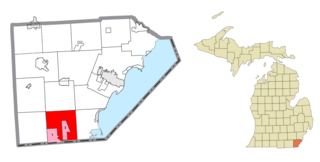
Carleton is a village in Monroe County in the U.S. state of Michigan. The population was 2,326 at the 2020 census. The village is located within Ash Township.

<span class="mw-page-title-main">Lambertville, Michigan</span> Census-designated place & unincorporated community in Michigan, United States

Lambertville is an unincorporated community and census-designated place (CDP) in Monroe County in the U.S. state of Michigan. The population was 10,433 at the 2020 census. The CDP is located within Bedford Township.

<span class="mw-page-title-main">Maybee, Michigan</span> Village in Michigan, United States

Maybee is a village in Monroe County in the U.S. state of Michigan. The population was 545 at the 2020 census. The village is located within Exeter Township. Maybee was established in 1873 and incorporated as a village in 1899.

<span class="mw-page-title-main">Petersburg, Michigan</span> City in Michigan, United States

Petersburg is a city in Monroe County in the U.S. state of Michigan. The population was 1,171 at the 2020 census.

<span class="mw-page-title-main">South Rockwood, Michigan</span> Village in Michigan, United States

South Rockwood is a village in Monroe County in the U.S. state of Michigan. The population was 1,587 at the 2020 census. The village is located within Berlin Charter Township.

<span class="mw-page-title-main">McBride, Michigan</span> Village in Michigan, United States

McBride is a village in Montcalm County in the U.S. state of Michigan. The population was 205 at the 2010 census. The village is located within Day Township. The post office for the village, with ZIP code 48852, is named "McBrides" and provides P.O. Box service to the village.

Buel Township is a civil township of Sanilac County in the U.S. state of Michigan. As of the 2020 census, the township population was 1,161.

Almer Charter Township is a charter township of Tuscola County in the U.S. state of Michigan. The population was 1,965 at the 2020 census. It is the only charter township in the Upper Thumb region of Michigan.

<span class="mw-page-title-main">Flat Rock, Michigan</span> City in Michigan, United States

Flat Rock is a city in Wayne County, Michigan, United States, with a small portion of the city extending into Monroe County. At the 2020 census, the population was 10,541.

<span class="mw-page-title-main">Milan, Michigan</span> City in Michigan, United States

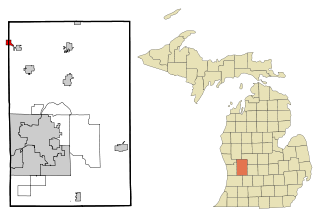
Milan is a city in Monroe and Washtenaw counties in the U.S. state of Michigan. The population was 6,079 at the 2020 census.

Brookfield Township is a civil township of Eaton County in the U.S. state of Michigan. As of the 2010 census, the township population was 1,537.

References

  1. 1 2 "2023 U.S. Gazetteer Files: Michigan". United States Census Bureau. Retrieved November 1, 2023.
  2. 1 2 "P1. Race – Estral Beach village, Michigan: 2020 DEC Redistricting Data (PL 94-171)". U.S. Census Bureau. Retrieved November 1, 2023.
  3. 1 2 "U.S. Census website". United States Census Bureau . Retrieved January 31, 2008.
  4. "US Board on Geographic Names". United States Geological Survey. October 25, 2007. Retrieved January 31, 2008.
  5. Romig, Walter (October 1, 1986) [1973]. Michigan Place Names: The History of the Founding and the Naming of More Than Five Thousand Past and Present Michigan Communities. p. 187. ISBN   978-0-8143-1838-6.{{cite book}}: |work= ignored (help)
  6. U.S. Fish & Wildlife Service (2021). "Detroit River International Wildlife Refuge: Map" . Retrieved October 31, 2021.
  7. UnitedStatesZipCodes.org (2021). "ZIP Code 48166: Newport" . Retrieved May 7, 2021.
  8. Google (May 11, 2021). "48166 ZIP Code map" (Map). Google Maps . Google. Retrieved May 11, 2021.
  9. Michigan Geographic Framework (November 15, 2013). "Monroe County School Districts" (PDF). Archived (PDF) from the original on August 21, 2014. Retrieved October 28, 2021.
  10. "Census of Population and Housing". Census.gov. Retrieved June 4, 2015.
  11. "U.S. Census website". United States Census Bureau . Retrieved November 25, 2012.