Berlin Charter Township, Michigan

Last updated
Berlin Township, Michigan
Berlin Charter Township
Berlin Charter Township Hall (Michigan).jpg
Berlin Township Office
Berlin Charter Township, MI location 2020.png
Left: Location within Monroe County and the administered villages of Estral Beach (1) and South Rockwood (2); Right: Location in the state of Michigan
USA Michigan location map.svg
Red pog.svg
Berlin Township
Usa edcp location map.svg
Red pog.svg
Berlin Township
Coordinates: 42°01′51″N83°16′09″W / 42.03083°N 83.26917°W / 42.03083; -83.26917
CountryUnited States
State Michigan
County Monroe
Organized1867
Government
  SupervisorDave Reaume
   Clerk Denise Sovey-Meyer
Area
[1]
  Total37.03 sq mi (95.9 km2)
  Land32.01 sq mi (82.9 km2)
  Water5.02 sq mi (13.0 km2)
Elevation
587 ft (179 m)
Population
 (2020) [2]
  Total9,890
  Density308.9/sq mi (119.3/km2)
Time zone UTC-5 (Eastern (EST))
  Summer (DST) UTC-4 (EDT)
ZIP Codes
48166 (Newport)
48179 (South Rockwood)
48134 (Flat Rock)
Area code 734
FIPS code 26-115-07720 [3]
GNIS feature ID1625924 [4]
Website www.berlinchartertwp.com

Berlin Charter Township is a charter township of Monroe County in the U.S. state of Michigan. At the 2020 census, the township population was 9,890. [2]

Contents

The township was organized in 1867 from the eastern portion of Ash Township. As part of the Monroe Metropolitan Area, the township is also included as part of the much larger Metro Detroit region.

Communities

Geography

Berlin Charter Township is in the northeast corner of Monroe County and is bordered on the south by Frenchtown Township and by Ash Township on the west. The Huron River forms most of the northern border of the township with Brownstown Township and the cities of Rockwood and Flat Rock in Wayne County.

According to the U.S. Census Bureau, the township has a total area of 37.03 square miles (95.91 km2), of which 32.01 square miles (82.9 km2) are land and 5.02 square miles (13.0 km2), or 13.56%, are water. [1]

Portions of the Pointe Mouillee State Game Area are located within Berlin Township. The township contains two listings on the National Register of Historic Places. The Detroit River Light is within the township's water boundaries just south of the mouth of the Detroit River. The Jefferson Avenue–Huron River Bridge crosses the Huron River, connecting Berlin Township to Brownstown Township along the U.S. Turnpike to Jefferson Avenue. It is one of the few listings on the National Register of Historic Places to span multiple counties.

Demographics

Historical population
CensusPop.Note
1870 1,844
1880 2,24621.8%
1890 1,906−15.1%
1900 1,820−4.5%
1910 1,687−7.3%
1920 1,657−1.8%
1930 2,25936.3%
1940 2,69219.2%
1950 3,55932.2%
1960 4,45925.3%
1970 5,51023.6%
1980 6,48817.7%
1990 6,286−3.1%
2000 6,92410.1%
2010 9,29934.3%
2020 9,8906.4%
U.S. Decennial Census [8]

As of the census [3] of 2000, there were 6,924 people, 2,511 households, and 1,923 families residing in the township. The population density was 215.8 inhabitants per square mile (83.3/km2). There were 2,654 housing units at an average density of 82.7 per square mile (31.9/km2). The racial makeup of the township was 97.11% White, 0.49% African American, 0.33% Native American, 0.07% Asian, 0.01% Pacific Islander, 0.58% from other races, and 1.40% from two or more races. Hispanic or Latino of any race were 1.43% of the population.

There were 2,511 households, out of which 35.5% had children under the age of 18 living with them, 64.7% were married couples living together, 7.9% had a female householder with no husband present, and 23.4% were non-families. 18.3% of all households were made up of individuals, and 5.1% had someone living alone who was 65 years of age or older. The average household size was 2.76 and the average family size was 3.15.

In the township the population was spread out, with 26.6% under the age of 18, 8.4% from 18 to 24, 30.1% from 25 to 44, 26.4% from 45 to 64, and 8.5% who were 65 years of age or older. The median age was 36 years. For every 100 females, there were 106.9 males. For every 100 females age 18 and over, there were 105.6 males.

The median income for a household in the township was $57,403, and the median income for a family was $64,071. Males had a median income of $48,431 versus $27,568 for females. The per capita income for the township was $23,898. About 2.9% of families and 5.6% of the population were below the poverty line, including 7.6% of those under age 18 and 5.6% of those age 65 or over.

Education

The southeastern portion of the township is served by Jefferson Schools, while the northwest portion of the township is served by Airport Community Schools. [9] A very small northwesternmost portion of the township is served by Flat Rock Community Schools. [10]

Highways

Images

Related Research Articles

<span class="mw-page-title-main">Alcona Township, Michigan</span> Civil township in Michigan, United States

Alcona Township is a civil township of Alcona County in the U.S. state of Michigan. The population was 966 at the 2020 census.

<span class="mw-page-title-main">Oscoda Township, Michigan</span> Charter township in Michigan, United States

Oscoda Township is a charter township of Iosco County in the U.S. state of Michigan. The population was 6,788 at the 2020 census. The Wurtsmith Air Force Base is located within the township.

<span class="mw-page-title-main">Ash Township, Michigan</span> Civil township in Michigan, United States

Ash Township is a civil township of Monroe County in the U.S. state of Michigan. As of the 2020 census, the township population was 7,860.

<span class="mw-page-title-main">Estral Beach, Michigan</span> Village in Michigan, United States

Estral Beach is a village in Monroe County in the U.S. state of Michigan. The population was 403 at the 2020 census. The village is located within Berlin Charter Township.

<span class="mw-page-title-main">Frenchtown Charter Township, Michigan</span> Charter township in Michigan, United States

Frenchtown Charter Township is a charter township within Monroe County in the U.S. state of Michigan. The population was 20,428 as per the 2010 census.

<span class="mw-page-title-main">London Township, Michigan</span> Civil township in Michigan, United States

London Township is a civil township of Monroe County in the U.S. state of Michigan. The population was 3,048 at the 2010 census.

<span class="mw-page-title-main">Monroe Charter Township, Michigan</span> Charter township in Michigan, United States

Monroe Charter Township is a charter township of Monroe County in the U.S. state of Michigan. As of the 2010 census, the township population was 14,568.

<span class="mw-page-title-main">South Rockwood, Michigan</span> Village in Michigan, United States

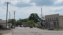
South Rockwood is a village in Monroe County in the U.S. state of Michigan. The population was 1,587 at the 2020 census. The village is located within Berlin Charter Township.

<span class="mw-page-title-main">Commerce Township, Michigan</span> Charter township in Michigan, United States

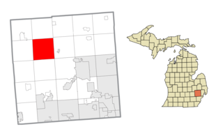
Commerce Township, officially the Charter Township of Commerce, is a charter township of Oakland County in the U.S. state of Michigan. The population was 40,186 at the 2010 census.

<span class="mw-page-title-main">Springfield Township, Oakland County, Michigan</span> Charter township in Michigan, United States

Springfield Charter Township is a charter township of Oakland County in the U.S. state of Michigan. As of the 2010 census, the township population was 13,940. The township was named for the numerous springs in the area.

<span class="mw-page-title-main">Ann Arbor Charter Township, Michigan</span> Charter township in Michigan, United States

Ann Arbor Charter Township is a charter township of Washtenaw County in the U.S. state of Michigan. The population was 4,673 at the 2020 census. The township borders the city of Ann Arbor and contains numerous exclaves, but the two are administered autonomously.

<span class="mw-page-title-main">Augusta Charter Township, Michigan</span> Charter township in Michigan, United States

Augusta Charter Township is a charter township of Washtenaw County in the U.S. state of Michigan. The population was 6,745 at the 2010 census.

<span class="mw-page-title-main">Superior Township, Washtenaw County, Michigan</span> Charter township in Michigan, United States

Superior Charter Township is a charter township of Washtenaw County in the U.S. state of Michigan. The population was 13,058 at the 2010 census.

<span class="mw-page-title-main">Ypsilanti Charter Township, Michigan</span> Charter township in Michigan, United States

Ypsilanti Charter Township is a charter township of Washtenaw County in the U.S. state of Michigan. The population was 53,362 at the 2010 census. The city of Ypsilanti is mostly surrounded by the township, but the two are administered autonomously.

<span class="mw-page-title-main">Brownstown Charter Township, Michigan</span> Charter township in Michigan, United States

Brownstown Charter Township is a charter township in Wayne County in the U.S. state of Michigan. Its population was 30,627 at the 2010 census. Brownstown was established in 1827, a decade prior to Michigan's admission to the Union.

<span class="mw-page-title-main">Canton, Michigan</span> American township in Michigan

Canton Township is a charter township in Wayne County in the U.S. state of Michigan. A western suburb of Detroit, Canton is located roughly 23 miles (37.0 km) west of downtown Detroit, and 15 miles (24.1 km) east of Ann Arbor. As of the 2020 census, the township had a population of 98,659, making it Michigan's second most-populated township and ninth most-populated municipality overall.

<span class="mw-page-title-main">Huron Charter Township, Michigan</span> Charter township in Michigan, United States

Huron Charter Township is a charter township of Wayne County in the U.S. state of Michigan. The population was 15,879 at the 2010 census. Huron Charter Township is named after the Huron River, which flows southeast through the township. The township is home to three divisions of the Huron–Clinton Metroparks system: Lower Huron, Oakwoods, and Willow.

<span class="mw-page-title-main">Sumpter Township, Michigan</span> Civil township in Michigan, United States

Sumpter Township is a civil township of Wayne County in the U.S. state of Michigan. The population was 9,660 at the 2020 census.

<span class="mw-page-title-main">Van Buren Township, Michigan</span> American township in Michigan

Van Buren Township is a charter township in Wayne County in the U.S. state of Michigan. A western suburb of Detroit, Van Buren Township is located roughly 28 miles (45.1 km) southwest of downtown Detroit, and 17 miles (27.4 km) southeast of Ann Arbor. As of the 2020 census, the township had a population of 30,375. It surrounds, but is independent of, the city of Belleville.

<span class="mw-page-title-main">Washington Township, Macomb County, Michigan</span> Charter township in Michigan, United States

Washington Charter Township, located within Metro Detroit, is a charter township of Macomb County in the U.S. state of Michigan. The population was 28,165 at the 2020 census, up from 25,139 in 2010.

References

  1. 1 2 "2023 U.S. Gazetteer Files: Michigan". United States Census Bureau. Retrieved November 1, 2023.
  2. 1 2 "P1. Race – Berlin charter township, Michigan: 2020 DEC Redistricting Data (PL 94-171)". U.S. Census Bureau. Retrieved November 1, 2023.
  3. 1 2 "U.S. Census website". United States Census Bureau . Retrieved 2008-01-31.
  4. U.S. Geological Survey Geographic Names Information System: Berlin Charter Township, Michigan
  5. U.S. Geological Survey Geographic Names Information System: Newport, Michigan
  6. U.S. Geological Survey Geographic Names Information System: Oldport, Michigan
  7. Romig, Walter (October 1, 1986) [1973]. Michigan Place Names: The History of the Founding and the Naming of More Than Five Thousand Past and Present Michigan Communities. p. 414. ISBN   978-0-8143-1838-6.{{cite book}}: |work= ignored (help)
  8. "Decennial Census Official Publications". U.S. Census Bureau. Retrieved November 1, 2023.
  9. Michigan Geographic Framework (15 November 2013). "Monroe County School Districts" (PDF). Archived (PDF) from the original on 2014-08-21. Retrieved June 18, 2021.
  10. Michigan Geographic Framework (15 November 2013). "Wayne County School Districts" (PDF). Archived (PDF) from the original on 2014-08-21. Retrieved June 18, 2021.