
The Capture of Hill 60 took place near Hill 60 south of Ypres on the Western Front, during the First World War. Hill 60 had been captured by the German 30th Division on 11 November 1914, during the First Battle of Ypres. Initial French preparations to raid the hill were continued by the British 28th Division, which took over the line in February 1915 and then by the 5th Division. The plan was expanded into an ambitious attempt to capture the hill, despite advice that Hill 60 could not be held unless the nearby Caterpillar ridge was also occupied. It was found that Hill 60 was the only place in the area not waterlogged and a French 3 ft × 2 ft mine gallery was extended.
The Ypres Salient, around Ypres, in Belgium, was the scene of several battles and a major part of the Western Front during World War I.

The Battle of Messines was an attack by the British Second Army, on the Western Front, near the village of Messines in West Flanders, Belgium, during the First World War. The Nivelle Offensive in April and May had failed to achieve its more grandiose aims, had led to the demoralisation of French troops and confounded the Anglo-French strategy for 1917. The attack forced the Germans to move reserves to Flanders from the Arras and Aisne fronts, relieving pressure on the French.

RE Grave, Railway Wood is a Commonwealth War Graves Commission (CWGC) memorial and war grave located in the Ypres Salient on the Western Front. It is located on the Bellewaerde Ridge near Zillebeke, about 4 kilometres east of Ypres, and a little north of Hooge. The area of the Cambridge Road sector, halfway in between Wieltje and Hooge, was the site of intensive underground fighting in the First World War. The Liverpool Scottish Memorial, Railway Wood is located nearby.
Royal Engineer tunnelling companies were specialist units of the Corps of Royal Engineers within the British Army formed to dig attacking tunnels under enemy lines during the First World War.

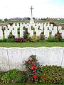
Lone Tree Cemetery is a Commonwealth War Graves Commission (CWGC) burial ground for the dead of the First World War located in the Ypres Salient on the Western Front in Belgium. It is located at Spanbroekmolen, on one of the highest points of the Messines Ridge.

Spanbroekmolen British Cemetery is a Commonwealth War Graves Commission (CWGC) burial ground for the dead of the First World War located in the Ypres Salient on the Western Front in Belgium. It is located at Spanbroekmolen, on one of the highest points of the Messines Ridge.
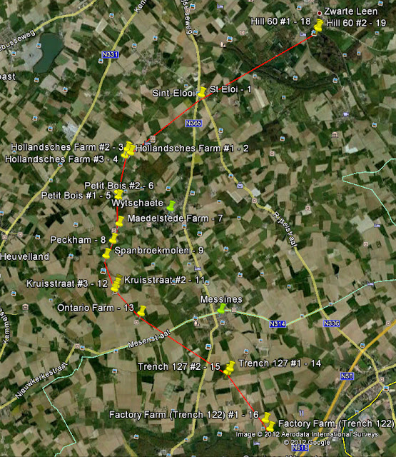
The Mines in the Battle of Messines comprised a series of underground explosive charges which were fired during the First World War at the start of the Battle of Messines (7–14 June 1917) by the British Second Army near the village of Mesen in Belgian West Flanders. The mines, secretly planted and maintained by British tunnelling units beneath the forward position of the German 4th Army, killed approximately 10,000 German soldiers and created 19 large craters. Their joint explosion ranks among the largest non-nuclear explosions of all time.
Sint-Elooi is a small village, about 5 km (3.1 mi) south of Ypres in the Flemish province of West Flanders in Belgium. The former municipality is now part of Ypres. Though Sint-Elooi is the Dutch and only official name, the village's French name, St. Eloi, is most commonly used in English due to its role in World War I. The village and the nearby locations of Voormezele and Hollebeke were merged into Zillebeke in 1970 and into Ypres in 1976.
The 177th Tunnelling Company was one of the tunnelling companies of the Royal Engineers created by the British Army during World War I. The tunnelling units were occupied in offensive and defensive mining involving the placing and maintaining of mines under enemy lines, as well as other underground work such as the construction of deep dugouts for troop accommodation, the digging of subways, saps, cable trenches and underground chambers for signals and medical services.
The 175th Tunnelling Company was one of the tunnelling companies of the Royal Engineers created by the British Army during World War I. The tunnelling units were occupied in offensive and defensive mining involving the placing and maintaining of mines under enemy lines, as well as other underground work such as the construction of deep dugouts for troop accommodation, the digging of subways, saps, cable trenches and underground chambers for signals and medical services.
In World War I, the area around Hooge on Bellewaerde Ridge, about 2.5 mi (4 km) east of Ypres in Flanders in Belgium, was one of the easternmost sectors of the Ypres Salient and was the site of much fighting between German and Allied forces.
The 171st Tunnelling Company was one of the tunnelling companies of the Royal Engineers created by the British Army during World War I. The tunnelling units were occupied in offensive and defensive mining involving the placing and maintaining of mines under enemy lines, as well as other underground work such as the construction of deep dugouts for troop accommodation, the digging of subways, saps, cable trenches and underground chambers for signals and medical services.
The 250th Tunnelling Company was one of the tunnelling companies of the Royal Engineers created by the British Army during World War I. The tunnelling units were occupied in offensive and defensive mining involving the placing and maintaining of mines under enemy lines, as well as other underground work such as the construction of deep dugouts for troop accommodation, the digging of subways, saps, cable trenches and underground chambers for signals and medical services.
The Actions of the Bluff were local operations in 1916 carried out in Flanders during the First World War by the German 4th Army and the British Second Army. The Bluff is a mound near St Eloi, south-east of Ypres in Belgium, created from a spoil heap made during the digging of the Ypres–Comines Canal before the war. From 14 to 15 February and on 2 March 1916, the Germans and the British fought for control of the Bluff, the Germans capturing the mound and defeating counter-attacks only for the British to recapture it and a stretch of the German front line, after pausing to prepare a set-piece attack.
The 182nd Tunnelling Company was one of the tunnelling companies of the Royal Engineers created by the British Army during World War I. The tunnelling units were occupied in offensive and defensive mining involving the placing and maintaining of mines under enemy lines, as well as other underground work such as the construction of deep dugouts for troop accommodation, the digging of subways, saps, cable trenches and underground chambers for signals and medical services.
The 3rd Canadian Tunnelling Company was one of the tunnelling companies of the Canadian Military Engineers during World War I. The tunnelling units were occupied in offensive and defensive mining involving the placing and maintaining of mines under enemy lines, as well as other underground work such as the construction of deep dugouts for troop accommodation, the digging of subways, saps, cable trenches and underground chambers for signals and medical services.
The 1st Canadian Tunnelling Company was one of the tunnelling companies of the Canadian Military Engineers during World War I. The tunnelling units were occupied in offensive and defensive mining involving the placing and maintaining of mines under enemy lines, as well as other underground work such as the construction of deep dugouts for troop accommodation, the digging of subways, saps, cable trenches and underground chambers for signals and medical services.

Hill 60 is a World War I battlefield memorial site and park in the Zwarteleen area of Zillebeke south of Ypres, Belgium. It is located about 4.6 kilometres (2.9 mi) from the centre of Ypres and directly on the railway line to Comines. Before the First World War the hill was known locally as Côte des Amants. The site comprises two areas of raised land separated by the railway line; the northern area was known by soldiers as Hill 60 while the southern part was known as The Caterpillar.
The Actions of St Eloi Craters from 27 March to 16 April 1916, were local operations in the Ypres Salient of Flanders, during the First World War by the German 4th Army and the British Second Army. Sint-Elooi is a village about 5 km (3.1 mi) south of Ypres in Belgium. The British dug six galleries under no man's land, placed large explosive charges under the German defences and blew them at 4:15 a.m. on 27 March. The 27th Division captured all but craters 4 and 5. The 46th Reserve Division counter-attacked but the British captured craters 4 and 5 on 30 March. The Canadian Corps took over, despite the disadvantage of relieving troops in action.


