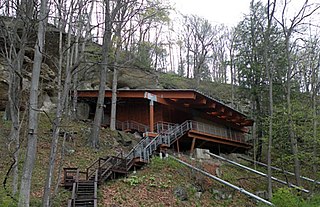
Meadowcroft Rockshelter is an archaeological site located near Avella in Jefferson Township, Washington County, Pennsylvania, United States. The site is a rock shelter in a bluff overlooking Cross Creek, and contains evidence that the area may have been continually inhabited for more than 19,000 years. If accurately dated, the site would be the earliest known evidence of human presence and the longest sequence of continuous human occupation in the New World.

The Thunderbird Archaeological District, near Limeton, Virginia, is an archaeological district described as consisting of "three sites—Thunderbird Site, the Fifty Site, and the Fifty Bog—which provide a stratified cultural sequence spanning Paleo-Indian cultures through the end of Early Archaic times with scattered evidence of later occupation."
The Lamoreau Site, also known as the Maine Archaeological Survey Site 23.13 is an historic archaeological site in Auburn, Maine. It is located on the grounds of the Auburn/Lewiston Municipal Airport. The site was listed on the National Register of Historic Places in 1989. It is named for its discoverer, Henry Lamoreau.
The Cape Site, designated Site 36.27 by the Maine Archaeological Survey, is a prehistoric archaeological site in West Leeds, Maine. Finds at the well-stratified waterfront site include ceramic fragments, stone tools, and remains of habitation dating as far as 6000 BCE. The site was listed on the National Register of Historic Places in 1992.

This is a list of the National Register of Historic Places listings in Androscoggin County, Maine.

The Massachusetts Hornfels-Braintree Slate Quarry is a prehistoric archaeological site in Milton and Quincy, Massachusetts. It consists of a series of pits and trenches used from 7,000 B.P. until the early 17th century as a source of slate and hornfels used for chipped and ground tools. Pieces made from material quarried at the site are found over much of eastern Massachusetts. The site was added to the National Register of Historic Places in 1980.
This is a list of the National Register of Historic Places listings in Williamson County, Tennessee.

The Mount Jasper Lithic Source is a prehistoric archaeological site in Berlin, New Hampshire. Located on the slopes of Mount Jasper on the north side of the city, it includes one of the only known evidences of mining by pre-Contact Native Americans in the eastern United States. The mountain is a source of rhyolite, apparently prized for its qualities in the manufacture of stone tools. The site includes a mine shaft about 9 metres (30 ft) deep, as well as workshops at the base and summit of the mountain. The site was added to the National Register of Historic Places in 1992.
The Coats-Hines-Litchy site is a paleontological site located in Williamson County, Tennessee in the Southeastern United States. The site was formerly believed to be archaeological, and identified as one of only a very few locations in Eastern North America containing evidence of Paleoindian hunting of late Pleistocene proboscideans. Excavations at the site have yielded portions of four mastodon skeletons, including portions of one previously described as being in direct association with Paleoindian stone tools. The results of excavations have been published in Tennessee Conservationist, and the scholarly journals Current Research in the Pleistocene, Tennessee Archaeology, and Quaternary Science Reviews. The site was listed on the National Register of Historic Places on July 12, 2011.

The Cary Village Site is an archaeological site in the west-central portion of the U.S. state of Ohio. Located southeast of the village of Plain City in Madison County, the site occupies a group of grassy terraces located amid two farm fields. In this grassy area, archaeologists have discovered a wide range of artifacts, including stone tools, materials made of flint, and various types of pottery.
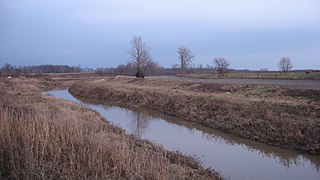
The Prairie Creek Site is an archaeological site in the southwestern part of the U.S. state of Indiana. Located approximately 3 miles (4.8 km) north of Washington in Daviess County, it lies along the southern bank of the westward-flowing Prairie Creek, a White River tributary. About 1 mile (1.6 km) to the east of the site, the stream leaves the Thousand Acre Woods, a heavily wooded area around a glacial lake; six miles downstream is the creek's confluence with the White River.
The Rumford Archaeological Sites are a collection of prehistoric Native American sites in the vicinity of the Androscoggin River near Rumford, Maine. These six sites provide a window of observation into the movements and practices of Native Americans from c. 7,000 BCE to the Late Woodland period and contact with Europeans. These sites are the subject of three separate listings on the National Register of Historic Places in 1972: the Rumford Falls I-IV Sites, the Rumford V Site, and the Town of Rumford Site. The locations of these sensitive sites are not generally publicized.
The LaGrange Rock Shelter is an archaeological site located on private property between Leighton and Muscle Shoals in Colbert County, Alabama, near the original campus of LaGrange College. The shelter measures 70 feet long by 15 feet deep and is located beneath a sandstone outcrop overlooking a dense series of Paleoindian sites in the valley below, which may have led to it being chosen for excavation.

The Munsungan-Chase Lake Thoroughfare Archeological District encompasses a series of important archaeological sites in a remote area of northern Maine, United States. These sites offer evidence of human habitation dating to not long after the retreat of the glaciers following the Wisconsin glaciation, with extensive stone tool workshops working with red chert found in abundance in the area. Stone tools made from sources in this region have been found at archaeological sites across New England. The district was listed on the National Register of Historic Places in 1979.
The Sebec-Piscataquis River Confluence Prehistoric Archeological District encompasses a collection of important prehistoric archaeological sites in Milo, Maine. Located near the mouth of the Sebec River where it meets the Piscataquis River, these sites include several deeply stratified sites covering 5,000 years of history dating back to 8,300 BCE. The area was listed on the National Register of Historic Places in 1986.
The Evergreens is a campground on Ferry Street in Solon, Maine, on the banks of the Kennebec River. The property has a documented archaeological history, with evidence of human habitation dating back thousands of years. It is also known that the military expedition of Benedict Arnold camped in this area in 1775 while en route to Quebec City in the American Revolutionary War. The property has had formal excavations by the Maine State Museum, and was listed on the National Register of Historic Places in 1982.
The Willard Brook Quarry is a prehistoric stone quarry site in a remote portion of Piscataquis County, Maine. The quarry site is located on one of a series of outcrops near Munsungan Lake in north-central Maine, all of which have yielded stone tools found at prehistoric sites throughout northern New England. The area is known to have been frequented by Native Americans, with an extensive array of habitation sites located in the area between Munsungan and Chase Lake. The Willard Brook quarry site provides evidence that Native Americans engaged in quarrying and mining operations to recover stone suitable for conversion to tools.
The Hedden Site, designated Site 4.10 by the Maine Archaeological Survey, is a prehistoric archaeological site in Kennebunk, Maine. The site has been radiocarbon dated to c. 8550 BCE, and is a rare example in the state of a completely undisturbed (unplowed), stratified site. The site was listed on the National Register of Historic Places in 1991.
Archeological Site No. 39.1 is a prehistoric archaeological site in Searsmont, Maine. Located on the floodplain of a waterway, it is one of the state's largest Paleo-Indian habitation sites, estimated by the surveying archaeologists to be about 18,000 square metres. The unstratified (single-layer) site is expected to contribute significantly to what is known about prehistoric human habitation patterns in the area, and was listed on the National Register of Historic Places in 1994 for this reason.
The Clampitt site (12Lr329) is a prehistoric archaeological site that sits on a sandy terrace along the East Fork of White River, southeast of Bedford in Lawrence County, Indiana. The site was excavated by the Indiana University archaeological field school in the summers of 1991 and 1992. The Clampitt site was added to the National Register of Historic Places in 2016. The site is located on private property. It is one of thirteen National Register of Historic Places listings in Lawrence County, Indiana.


