Spring Hill, Minnesota

Last updated
Spring Hill
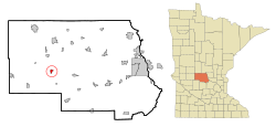
Stearns County Minnesota Incorporated and Unincorporated areas Spring Hill Highlighted.svg
Location of Spring Hill
within Stearns County, Minnesota
Coordinates: 45°31′24″N94°49′54″W / 45.52333°N 94.83167°W / 45.52333; -94.83167
Country United States
State Minnesota
County Stearns
Area
[1]
  Total0.73 sq mi (1.88 km2)
  Land0.73 sq mi (1.88 km2)
  Water0.00 sq mi (0.00 km2)
Elevation
[2]
1,250 ft (380 m)
Population
 (2020)
  Total68
  Density93.41/sq mi (36.09/km2)
Time zone UTC-6 (Central (CST))
  Summer (DST) UTC-5 (CDT)
FIPS code 27-61888 [3]
GNIS feature ID2395932 [2]

Spring Hill is a city in Stearns County, Minnesota, United States. The population was 85 at the 2010 census. [4] It is part of the St. Cloud Metropolitan Statistical Area.

Contents

Minnesota State Highway 4 serves as a main route in the community.

Geography

According to the United States Census Bureau, the city has a total area of 0.72 square miles (1.86 km2), all land. [5]

Demographics

Historical population
CensusPop.Note
1910 100
1920 11212.0%
1930 102−8.9%
1940 87−14.7%
1950 914.6%
1960 10515.4%
1970 90−14.3%
1980 944.4%
1990 77−18.1%
2000 55−28.6%
2010 8554.5%
2020 68−20.0%
U.S. Decennial Census [6]

2010 census

As of the census [7] of 2010, there were 85 people, 34 households, and 22 families living in the city. The population density was 118.1 inhabitants per square mile (45.6/km2). There were 39 housing units at an average density of 54.2 per square mile (20.9/km2). The racial makeup of the city was 100.0% White.

There were 34 households, of which 29.4% had children under the age of 18 living with them, 52.9% were married couples living together, 5.9% had a female householder with no husband present, 5.9% had a male householder with no wife present, and 35.3% were non-families. 32.4% of all households were made up of individuals, and 26.5% had someone living alone who was 65 years of age or older. The average household size was 2.50 and the average family size was 3.09.

The median age in the city was 44.8 years. 22.4% of residents were under the age of 18; 7% were between the ages of 18 and 24; 21.2% were from 25 to 44; 24.7% were from 45 to 64; and 24.7% were 65 years of age or older. The gender makeup of the city was 49.4% male and 50.6% female.

2000 census

As of the census [3] of 2000, there were 55 people, 26 households, and 12 families living in the city. The population density was 75.4 inhabitants per square mile (29.1/km2). There were 26 housing units at an average density of 35.7 per square mile (13.8/km2). The racial makeup of the city was 100.00% White.

There were 26 households, out of which 11.5% had children under the age of 18 living with them, 34.6% were married couples living together, 11.5% had a female householder with no husband present, and 53.8% were non-families. 46.2% of all households were made up of individuals, and 30.8% had someone living alone who was 65 years of age or older. The average household size was 2.12 and the average family size was 3.17.

In the city, the population was spread out, with 16.4% under the age of 18, 10.9% from 18 to 24, 23.6% from 25 to 44, 23.6% from 45 to 64, and 25.5% who were 65 years of age or older. The median age was 44 years. For every 100 females, there were 89.7 males. For every 100 females age 18 and over, there were 84.0 males.

The median income for a household in the city was $25,833, and the median income for a family was $43,125. Males had a median income of $24,375 versus $16,250 for females. The per capita income for the city was $16,271. There were no families and 11.9% of the population living below the poverty line, including no under eighteens and 29.4% of those over 64.
Related Research Articles

<span class="mw-page-title-main">Willey, Iowa</span> City in Iowa, United States

Willey is a city in Carroll County, Iowa, United States. The population was 73 at the time of the 2020 census.

<span class="mw-page-title-main">Woodburn, Iowa</span> City in Iowa, United States

Woodburn is a city in Clarke County, Iowa, United States. The population was 146 at the time of the 2020 census.

<span class="mw-page-title-main">Schleswig, Iowa</span> City in Iowa, United States

Schleswig is a city in Crawford County, Iowa, United States. The population was 830 at the time of the 2020 census.

<span class="mw-page-title-main">Orleans, Iowa</span> City in Iowa, United States

Orleans is a city in Dickinson County, Iowa, United States. The population was 521 at the time of the 2020 census. Orleans is part of the Iowa Great Lakes region, located along Spirit Lake. Numerous state parks are located within a few miles of the town, including Marble Beach and Mini-Wakan.

<span class="mw-page-title-main">St. Lucas, Iowa</span> City in Iowa, United States

St. Lucas is a city in Fayette County, Iowa, United States. The population was 167 at the time of the 2020 census.

<span class="mw-page-title-main">Braddyville, Iowa</span> City in Iowa, United States

Braddyville is a city in Page County, Iowa, United States. The population was 147 at the 2020 census.

<span class="mw-page-title-main">Craig, Iowa</span> City in Iowa, United States

Craig is a city in Plymouth County, Iowa, United States. The population was 79 at the 2020 census.

<span class="mw-page-title-main">Dixon, Iowa</span> City in Iowa, United States

Dixon is a city in Scott County, Iowa, United States. The population was 202 at the time of the 2020 census.

<span class="mw-page-title-main">New Virginia, Iowa</span> City in Iowa, United States

New Virginia is a city in Warren County, Iowa, United States. The population was 498 at the time of the 2020 census. It is part of the Des Moines–West Des Moines Metropolitan Statistical Area.

<span class="mw-page-title-main">Westfield, Maine</span> Town in the state of Maine, United States

Westfield is a town in Aroostook County, Maine, United States. The population was 455 at the 2020 census.

<span class="mw-page-title-main">North Muskegon, Michigan</span> City in Michigan, United States

North Muskegon is a city in Muskegon County in the U.S. state of Michigan. The population was 3,786 at the 2010 census.

<span class="mw-page-title-main">Elizabeth, Minnesota</span> City in Minnesota, United States

Elizabeth is a city in Otter Tail County, Minnesota, United States. The population was 168 at the 2020 census.

<span class="mw-page-title-main">Lake Henry, Minnesota</span> City in Minnesota, United States

Lake Henry is a city in Stearns County, Minnesota, United States. The population was 103 at the 2010 census. It is part of the St. Cloud Metropolitan Statistical Area.

<span class="mw-page-title-main">Pine Springs, Minnesota</span> City in Minnesota, United States

Pine Springs is a city in Washington County, Minnesota, United States. The population was 408 at the 2010 census.

<span class="mw-page-title-main">Smithton, Missouri</span> City in Missouri, United States

Smithton is a city in Pettis County, Missouri, United States. The population was 570 at the 2010 census.

<span class="mw-page-title-main">Pleasant Hope, Missouri</span> City in Missouri, United States

Pleasant Hope is a city in Polk County, Missouri, United States. The population was 614 at the 2010 census. It is part of the Springfield, Missouri Metropolitan Statistical Area.

<span class="mw-page-title-main">Country Club Hills, Missouri</span> City in Missouri, United States

Country Club Hills is a city in St. Louis County, Missouri, United States. The population was 1,274 at the 2010 census.

<span class="mw-page-title-main">Harrisburg, Oregon</span> City in Oregon, United States

Harrisburg is a city in Linn County, Oregon, United States. The population was 3,567 at the 2010 census.

<span class="mw-page-title-main">Sublimity, Oregon</span> City in Oregon, United States

Sublimity is a city in Marion County, Oregon, United States. The population was 2,967 at the 2020 census. It is part of the Salem Metropolitan Statistical Area.

<span class="mw-page-title-main">Dennison, Minnesota</span> City in Minnesota, United States

Dennison is a city in Goodhue and Rice counties in the U.S. state of Minnesota. The population was 212 at the 2010 census. Most of Dennison is in Goodhue County, with only a small part that extends into Rice County.

References

  1. "2020 U.S. Gazetteer Files". United States Census Bureau. Retrieved July 24, 2022.
  2. 1 2 U.S. Geological Survey Geographic Names Information System: Spring Hill, Minnesota
  3. 1 2 "U.S. Census website". United States Census Bureau . Retrieved 2008-01-31.
  4. "2010 Census Redistricting Data (Public Law 94-171) Summary File". American FactFinder. U.S. Census Bureau, 2010 Census. Retrieved 23 April 2011.[ dead link ]
  5. "US Gazetteer files 2010". United States Census Bureau. Archived from the original on 2012-01-25. Retrieved 2012-11-13.
  6. "Census of Population and Housing". Census.gov. Retrieved June 4, 2015.
  7. "U.S. Census website". United States Census Bureau . Retrieved 2012-11-13.