
Perry County is a county located in the U.S. state of Arkansas. Its population was 10,019 at the 2020 United States Census. The county seat is Perryville. The county was formed on December 18, 1840, and named for Commodore Oliver Hazard Perry, naval hero in the War of 1812. It is an alcohol prohibition or dry county.
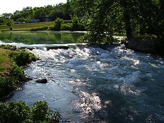
Mammoth Spring State Park is a 62.5-acre (25.3 ha) Arkansas state park in Fulton County, Arkansas in the United States. The park is located surrounding National Natural Landmark of the same name to provide recreation and interpretation for visitors. The park offers fishing, boating and hiking in addition to an Arkansas Welcome Center and restored 1886 Kansas City, Fort Scott and Memphis Railroad depot operating as a railroad museum. The site became a state park in 1957, but the park continued to add area until 1975.
Chickasaw National Recreation Area is a national recreation area in the foothills of the Arbuckle Mountains in south-central Oklahoma near Sulphur in Murray County. It includes the former Platt National Park and Arbuckle Recreation Area.

Lake Dardanelle is a major reservoir on the Arkansas River in Arkansas, USA. and is an integral part of the McClellan-Kerr Arkansas River Navigation System (MKARNS), which allows barge transportation from the Mississippi River to the Tulsa Port of Catoosa in northeastern Oklahoma. MKARNS went into service along its full length in 1971.

Capital Springs State Recreation Area is a state park unit of Wisconsin, United States, in development just south of Madison. The total area of the park is 3,000 acres (1,200 ha), with 326 acres (132 ha) designated as a state park. The park was authorized in 2000, the centennial of the Wisconsin state park system. The park includes 3,700 feet (1,100 m) of undeveloped shoreline on Lake Waubesa. The recreation area incorporates existing Dane County parks, and the site will be jointly managed by the state and the county.

Backbone State Park is Iowa's oldest state park, dedicated in 1919. Located in the valley of the Maquoketa River, it is approximately three miles (5 km) south of Strawberry Point in Delaware County. It is named for a narrow and steep ridge of bedrock carved by a loop of the Maquoketa River originally known as the Devil's Backbone. The initial 1,200 acres (490 ha) were donated by E.M. Carr of Lamont, Iowa. Backbone Lake Dam, a relatively low dam built by the Civilian Conservation Corps (CCC) in the 1930s, created Backbone Lake. The CCC constructed a majority of trails and buildings which make up the park.
Knob Noster State Park is a public recreation area covering 3,934 acres (1,592 ha) in Johnson County, Missouri, in the United States. The state park bears the name of the nearby town of Knob Noster, which itself is named for one of two small hills or "knobs" that rise up in an otherwise flat section of Missouri. Noster is a Latin adjective meaning "our"—therefore, Knob Noster translates as "our hill." A local Indian belief stated that the hills were "raised up as monuments to slain warriors." The park offers year-round camping, hiking, and fishing and is managed by the Missouri Department of Natural Resources.
Athens is an unincorporated community in the northeastern corner of Howard County, Arkansas, United States. It is located at the junction of Arkansas Highways 84 and 246.

Arkansas Highway 309 is a designation for two state highways in Western Arkansas. One route of 5.11 miles (8.22 km) runs from Yell County Route 28 (CR 28) at Blue Mountain Lake northeast to Highway 10 at Waveland. A second segment begins at Highway 10 in Havana and winds northwest through the Ozark National Forest to Highway 23 at Webb City via Paris. A portion of the second route is designated as the Mount Magazine Scenic Byway, one of eleven Arkansas Scenic Byways maintained by the Arkansas State Highway and Transportation Department (AHTD).

The Lake Wedington Historic District is a US Historic District in Washington County, Arkansas. The 170-acre (69 ha) historic district is located within the 424-acre (172 ha) Lake Wedington Recreation Area.

The Bard Springs Bathhouse is a historic recreational support facility in Ouachita National Forest. It is located at the Bard Springs recreation site, southeast of Mena and north of Athens in Polk County, off County Road 82 and Forest Road 106 on the banks of Blaylock Creek. It is a single story rustic stone structure, with entrances at either end into open areas for changing. The interior is lit by skylights in the roof. It was built in 1936 by a crew of the Civilian Conservation Corps, and is one of four surviving CCC structures in the immediate area.
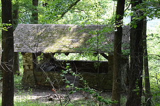
The Bard Springs Picnic Shelter is a historic recreational support facility in Ouachita National Forest. It is located at the Bard Springs recreation site, southeast of Mena and north of Athens in Polk County, off County Road 82 and Forest Road 106 on the banks of Blaylock Creek. It is a square open-air structure, with four rustic stone columns supporting a gabled roof. The foundation is stone, with the support columns set in concrete blocks. It was built in 1936 by a crew of the Civilian Conservation Corps, and is one of four surviving CCC structures in the immediate area.

Shady Lake Recreation Area is a campground and public recreation area in southwestern Ouachita National Forest, southwest of Mena, Arkansas and west of Glenwood, Arkansas. The area is oriented around Shady Lake, a body of water on the South Fork Saline River impounded by a dam built c. 1940 by the Civilian Conservation Corps (CCC). The area is administered by the United States Forest Service (USFS).

The Mirror Lake Historic District encompasses Mirror Lake, a man-made lake in the Ozark-St. Francis National Forest near Fifty-Six, Arkansas. The lake was created by a crew of the Civilian Conservation Corps in 1940 by damming the creek emanating from Blanchard Spring. The district includes the lake, the dam, and two bridges, one of which was also built by the CCC, and a CCC-built observation shelter nearby. The area is now part of the Blanchard Springs Recreation Area.
The Gray Spring Recreation Area is a picnic area with scenic views in the Ozark-St. Francis National Forest of northwestern Arkansas. It is located on northern Franklin County, on Forest Road 1003, and includes a picnic shelter, comfort facilities, an outdoor barbecue pit, and picnic tables. The picnic area and Forest Road 1003 were built in 1934 by a crew from the Civilian Conservation Corps, and were listed on the National Register of Historic Places in 1995. The road, which winds precariously around Black Mountain, retains a number of surviving CCC-built features, including a bridge and many stone culverts.

The Charlton Recreation Area is a public use area of the Ouachita National Forest, located just north of United States Route 270 between Crystal Springs and Mount Ida, Arkansas. The area includes a campground and day use facilities for water-related activities on Walnut Creek, including fishing and swimming. The facilities are organized around a small artificial lake created in 1938 by a crew of the Civilian Conservation Corps by damming the creek. The stone Charlton Dam and Spillway, about 100 feet (30 m) in length, was listed on the National Register of Historic Places 1993, as was the stone Charlton Bathhouse, also built by the CCC in 1938.
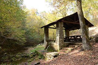
The Collier Springs Picnic Area is located on Forest Road 177 in Ouachita National Forest, northeast of Norman, Arkansas. The picnic area is notable for the presence of the Collier Springs Shelter, which was built by crews of the Civilian Conservation Corps in 1939. It is a rectangular open-air stone structure, with stone columns topped by hewn log beams that support the gabled roof. The shelter also acts as a protective cover for the eponymous spring, which is fed via a pipe to the nearby creek. Facilities at the picnic area also include a vault toilet.

The Iron Springs Recreation Area is a roadside picnic area on Arkansas Highway 7, north of Jessieville in the Ouachita National Forest. The area has three shelters for picnicking, vault toilets, and an accessible trail for viewing the springs in the area. The facilities were largely built by the Civilian Conservation Corps (CCC) in the 1930s, with two shelters and the nearby dam listed on the National Register of Historic Places.
Valhalla Highlands Historic District, also known as Lake Valhalla, is a national historic district located near Cold Spring in Putnam County, New York. The district encompasses 57 contributing buildings, 11 contributing sites, 10 contributing structures, 7 contributing objects and a 900-acre forest in an early second home community established by primarily German/Austrians and Norwegians from New York City. It developed between the early-1930s and mid-1940s, and includes lodges that are typically one or two stories high and have fieldstone foundations. They are characterized by structural stone walls and full log construction and frame dwellings clad with half-log wood siding and fieldstone veneer, chimneys and terraces. The district also includes a boat lodge with a ping-pong room and terrace, a swimming dock, a boat dock, a tea pavilion, a recreation pavilion, a lookout pavilion, shuffleboard courts, a tennis court, a playing field, a picnic area, rustic improvements throughout the forest and the remnants of a hunting cabin.
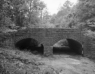
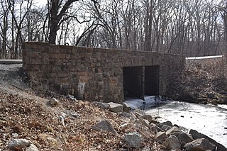
The Spring Lake Bridge is a historic bridge in the eastern part of Ozark-St. Francis National Forest, carrying County Road 35 across an inlet of Spring Lake known as Bob Barnes Branch, in the Spring Lake Recreation Area with the Ozark–St. Francis National Forest. It is a two-span closed-spandrel stone arch bridge with a total length of 36 feet (11 m). Each arch is 10 feet (3.0 m) long and 6 feet (1.8 m) high. Built in 1936 with federal funding, it is one of the state's finest examples of a stone arch bridge.


