Sprouts of the Mohawk River

Last updated
The First, or South, Branch of the Mohawk River, Simmons Island on the right and Van Schaick Island on the left Firstbranch.jpg
The First, or South, Branch of the Mohawk River, Simmons Island on the right and Van Schaick Island on the left

The Sprouts of the Mohawk River are the multiple channels of the Mohawk River as it flows into the Hudson River creating a delta in the US state of New York. [1] Most of the sprouts lie within Albany County, with the northern ones in Saratoga County, and the sprouts enter the Hudson at the boundary with Rensselaer County. The islands formed by the sprouts are, from north to south Peebles Island, [2] Polrump Island,  [3] Bock Island, Goat Island, Second Island, [2] Van Schaick Island, [4] Simmons Island. [5] and formerly Green Island. [6] The sprout separating Green Island from the rest of Albany County was filled in with the creation of Interstate 787 and NY Route 787.

Contents

History

Henry Hudson's crew may have reached as far as the sprouts in 1609 when Hudson sent a small boat with his first mate and four crew members from Half Moon up the Hudson River to see if the river was indeed the Northwest Passage. [6] The islands and sprouts (spuyten in Dutch) along with land along the northern shore of the northern sprouts was part of a tract of land deeded to Philip Pieterse Schuyler and Gozen Gerritse Van Schaick in 1665. The Native Americans called the area Nach-te-Nack, and by the Dutch settlers Halve-Maen (translated as Halfmoon in English). In 1674 Schuyler gave up his rights to the land to Van Schaick, and in 1687 Van Schaick's son Anthony Van Schaick was confirmed sole owner through patent title by Governor Thomas Dongan. [7]

Portions of the sprouts were very shallow, 2 feet (0.61 m) or less, and allowed for easy fording of the river. Waterford received its name from the ford connecting the village to Peebles Island, a name which became popular through use by soldiers in the US Revolutionary War. [3] The fords connecting the islands were used by the local Native Americans, the Mohicans and by the Dutch and English at Fort Orange and Albany en route to Montreal and Canada, being used by soldiers in the French and Indian Wars. During the American Revolutionary War the islands were the site of military fortifications protecting the fords and river road leading to Albany from invasion forces coming from Canada. Numerous fortifications were constructed on Peebles and Van Schaick Island, with the Van Schaick House being the military headquarters. [8]

The Rensselaer and Saratoga Railroad (incorporated 1832) crossed onto Green Island from Troy over the Hudson River and then traveled north over three of the sprouts, crossing into Saratoga County. [9]

In 1828 the King's Power Canal was constructed with two dams thrown across the Fourth Branch, between Waterford and Bock Island and then between Bock and Peebles. [3]

The state dam between Cohoes and Waterford, located where the sprouts exit from the main channel of the Mohawk River, was rebuilt 12 feet (3.7 m) east (downstream) of the old dam in 1868. Both the original and the new dam were for the original path of the Champlain Canal, allowing the canal boats to cross the Mohawk River to the canal channel on the other side in place of using an aqueduct bridge over the river. The original dam was too low and boats often went over the edge, the newer dam being 15 inches (380 mm) taller was to cut down on that problem. [10]

Sprouts

Fourth, or North, Branch of the Mohawk River surrounding Bock Island NorthbranchMohawkRiver.jpg
Fourth, or North, Branch of the Mohawk River surrounding Bock Island

Throughout the years the individual sprouts have been given different names. From north to south the sprouts are theFourth Branch, dividing Peebles Island from the mainland of Saratoga County; the Third Branch, separating Peebles from Van Schaick; the First Branch separating Van Schaick and Green islands from the mainland of Albany County; and the Second Branch, separating Van Schaick from Green Island. [11] The Fourth Branch is also known as the North Sprout; and the Third Branch as the Middle Branch, which is the location of a rapid called Buttermilk Falls. [2] The Middle Branch or sprout was also referred to as the White Sprout by the New York State Assembly in 1833. [12] The name Fourth Branch is still used in reference to the hydroelectric power plant located in the town of Waterford. [13] The center of the Third Branch is the political boundary between Saratoga and Albany counties while the Second Branch is the boundary between the city of Cohoes and the town/village of Green Island.

Islands

Recreation

Peebles Island is part of the Peebles Island State Park, an undeveloped park with recreational hiking paths and remnants of historical battleworks thrown up during the US Revolutionary War. The New York State Office of Parks, Recreation and Historic Preservation headquarters is located on the island. [3] There is a public fishing site on the northern end of Simmons Island, [5] and Peebles Island has shoreline fishing spots and areas where the river can be safely waded in. [14] All fishing in the sprouts is catch and release due to the presence of PCB. [3] A former railroad bridge over the Second Branch, variously referred to as the Black, Delaware, or CohoesGreen Island bridge was renovated as part of a bike/hike trail connecting the cities and villages of Watervliet, Green Island, Cohoes, and Waterford. [15] A visitor's center with public docks are on the northern shore of the Fourth Branch in the village of Waterford.

There are designated swimming areas and there are individuals who enjoy river surfing. [16]

See also

Related Research Articles

<span class="mw-page-title-main">Cohoes, New York</span> City in New York, United States

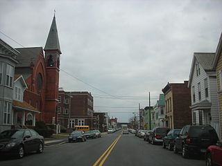
Cohoes is an incorporated city located in the northeast corner of Albany County in the U.S. state of New York. It is called the "Spindle City" because of the importance of textile manufacturing to its growth in the 19th century. The city's factories processed cotton from the Deep South.

<span class="mw-page-title-main">Green Island, New York</span> Town and village in New York, United States

Green Island is a coterminous town-village in Albany County, New York, United States, some 8 miles (13 km) north of Albany. Green Island is one of only five such town-village amalgamations in New York. The population was 2,934 at the 2020 census, and the ZIP code is 12183. While the town of Green Island was once an island, it was connected to the mainland on the west side of the Hudson River in the 1960s.

<span class="mw-page-title-main">Waterford (village), New York</span> Village in New York, United States

Waterford is a village in Saratoga County, New York, United States. The population was 1,990 at the 2010 census. The name derives from the ford between the mainland and Peebles Island.

<span class="mw-page-title-main">Waterford, New York</span>

Waterford is a town in Saratoga County, New York, United States. The population was 8,423 at the 2010 census. The name of the town is derived from its principal village, also called Waterford. The town is located in the southeast corner of Saratoga County and north-northwest of Troy at the junction of the Erie Canal and the Hudson River.

<span class="mw-page-title-main">Peter Gansevoort</span> American army officer (1749–1812)

Peter Gansevoort was a Colonel in the Continental Army during the American Revolutionary War. He is best known for leading the resistance to Barry St. Leger's Siege of Fort Stanwix in 1777. Gansevoort was also the maternal grandfather of Moby-Dick author Herman Melville.

<span class="mw-page-title-main">Mohawk River</span> River in the U.S. state of New York

The Mohawk River is a 149-mile-long (240 km) river in the U.S. state of New York. It is the largest tributary of the Hudson River. The Mohawk flows into the Hudson in Cohoes, New York, a few miles north of the state capital of Albany. The river is named for the Mohawk Nation of the Iroquois Confederacy. A major waterway, in the early 19th century, the river's east-west valley provided the setting and water for development of the Erie Canal, as a key to developing New York. The largest tributary, the Schoharie Creek, accounts for over one quarter (26.83%) of the Mohawk River's watershed. Another main tributary is the West Canada Creek, which makes up for 16.33% of the Mohawk's watershed.

<span class="mw-page-title-main">Peebles Island State Park</span> State park in New York, United States

Peebles Island State Park is a 190-acre (0.77 km2) state park located at the confluence of the Mohawk and Hudson rivers in New York. A majority of the park is located in Saratoga County, with a smaller portion located in Albany County.

<span class="mw-page-title-main">New York State Route 470</span> State highway in the Capital District of New York, US

New York State Route 470 (NY 470) is an east–west state highway in the Capital District of New York in the United States. It extends for 2.91 miles (4.68 km) from an intersection with NY 9R in the town of Colonie to a junction with U.S. Route 4 (US 4) in the city of Troy. Along the way, NY 470 intersects NY 787 in Cohoes and traverses the Hudson River via the 112th Street Bridge. NY 470 was assigned in February–March 1973 and is maintained by the cities of Cohoes and Troy.

<span class="mw-page-title-main">New York State Route 787</span> State highway in Albany County, New York, US

New York State Route 787 (NY 787) is a state highway in Albany County, New York, in the United States. It is a northern extension of Interstate 787 (I-787), continuing northward from the underpass at exit 9 for NY 7 near Green Island to downtown Cohoes at NY 32. NY 787 is a four-lane divided boulevard named Cohoes Boulevard. For its entire length, NY 787 runs parallel to, and between, NY 32 and the Hudson River.

Truman Giles Younglove was an American civil engineer and politician who served four years on the New York State Assembly.

<span class="mw-page-title-main">Mohawk Towpath Scenic Byway</span>

The Mohawk Towpath Scenic Byway is a National Scenic Byway in the Capital District region of New York in the United States. It extends from Schenectady to Waterford by way of a series of local, county, and state highways along the Mohawk River and the Erie Canal. The byway is intended to showcase the history of the waterway, from Native American times through the creation of the Erie Canal and the role the waterside communities played in the Industrial Revolution and the westward expansion of the United States. At its east end, the byway connects to the Lakes to Locks Passage, an All-American Road.

<span class="mw-page-title-main">Mohawk-Hudson Bike-Hike Trail</span>

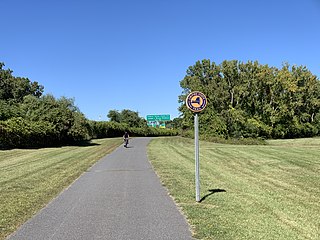
The Mohawk-Hudson Bike-Hike Trail (MHBHT) is a 97-mile (156 km) trail in New York's Mohawk Valley and Capital District regions. It is also the easternmost segment of the Erie Canalway Trail, as well as a portion of the Empire State Trail.

<span class="mw-page-title-main">Van Schaick Island</span>

Van Schaick Island is an island in the city of Cohoes, New York. Van Schaick is a part of the delta of the Mohawk River at its mouth with the Hudson River. The island has been referred to by numerous names including Quehemesicos, Long, Anthony's, Isle of Cohoes, and Cohoes Island. The island was home to US Revolutionary War fortifications in the 18th century, and to an important shipyard in the 20th century. The shipyard and the extreme northern end of the island is part of the Peebles Island State Park, and the only vehicular entrance to the state park is on the island.

<span class="mw-page-title-main">Niska Isle</span>

Niska Isle, despite its name, is not an island, but a peninsula in the town of Niskayuna, New York. Niska Isle is along the Mohawk River's south shore, with a back bay and swamp that surrounds it to the south.

<span class="mw-page-title-main">Van Schaick House</span> Historic house in New York, United States

Van Schaick House is a historic home located on Van Schaick Island at Cohoes in Albany County, New York. It was built about 1735 for Anthony Van Schaick, and is a 1+12-story, brick dwelling with a gambrel roof. Plans were made at the mansion for the Battle of Saratoga and the house was used by Governor Clinton as the New York State Capitol from August 22 to 25, 1777.

Matton Shipyard is a historic shipyard and canal boat service yard located on Van Schaick Island at Cohoes in Albany County, New York. It consists of eight extant buildings, various surviving features, and archaeological remains dating to the period 1916 to 1983 when the site functioned as a shipyard, repair facility, and towboat operation on the New York State Barge Canal and Champlain Canal. Extant buildings include the office / stores, watchman's building, sheet metal shop, carpenter shop, stores building, pipeshop, pitch building (pre-1936), garage, and electric building. Also on the property are a flagpole, dock, steel launching ramps, fence, and camels. Numerous ruins also occupy the property. The motor ship Day Peckinpaugh is berthed here.

<span class="mw-page-title-main">Kayaderossera patent</span>

The Kayaderossera Patent was a grant of land made by Anne, Queen of Great Britain in 1701 to thirteen subjects. The patent included 406,000 acres (164,000 ha) comprising most of what is now Saratoga County and parts of Montgomery, Schenectady, and Fulton Counties.

<span class="mw-page-title-main">Empire State Trail</span> Hiking and biking trail in New York State

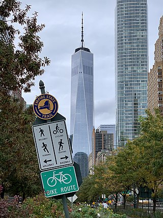
The Empire State Trail is a multi-use trail in New York State that was proposed by Governor Andrew Cuomo in January 2017 and completed in December 2020. The trail runs from Manhattan north to the Canada–United States border in Rouses Point near the northern tip of Lake Champlain, and also from Buffalo to Albany. At 750 miles (1,210 km), it is the longest multi-use trail in the United States. The trail includes pre-existing trail segments, which retain their existing identity but are now co-signed as a segment of the Empire State Trail. The trail also links to other regional bicycling and hiking trails such as the Appalachian Trail, the Adirondack and Catskill Parks, the Great Lakes Seaway Trail, the Genesee Valley Greenway, and others. A segment near its southernmost part, on the Hudson River Greenway in Manhattan, is concurrent with the East Coast Greenway. The trail is used for hiking, biking, snowshoeing, cross-country skiing and in some areas snowmobiling.

<span class="mw-page-title-main">Waterford Flight</span>

The Waterford Flight is a set of locks on the Erie Canal in upstate New York. Erie Canal Locks E-2 through E-6 make up the combined flight at Waterford, which lifts vessels from the Hudson River to the Mohawk River, bypassing Cohoes Falls. Built in 1915, the Waterford Flight is still in use today as part of the New York State Canal System, which is open to public and commercial traffic. The Waterford Flight is the series of locks with the highest elevation gain relative to its length for any canal lock system in the United States.

References

  1. Senate of the State of New York (1849). Documents of the Senate of the State of New-York, Seventy-Second Session. Vol. 2. Weed, Parsons & Co. p. 210.
  2. 1 2 3 Adams, Arthur G. (1996). The Hudson River Guidebook. TechType. ISBN   0-8232-1679-9.
  3. 1 2 3 4 5 6 7 8 9 10 "Section II: Inventory and Analysis". New York Department of State, Division of Coastal Resources.
  4. Davison, O.M. (1840). The Traveller's Guide Through the Middle and Northern States, and the Province of Canada. S.S. and W. Wood. p. 130.
  5. 1 2 Ingraham, Frances (1996-10-06). "Simmons Island: A Riverfront Cohoes Community". Times Union (Albany). Hearst Communications. p. F1.
  6. 1 2 Howell, George Rogers; Tenney, Jonathan (1886). Bi-Centennial History of Albany:History of the County of Albany, N.Y., from 1609 to 1886. W.W. Munsell & Co.
  7. Reynolds, Cuyler, ed. (1914). Genealogical and Family History of Southern New York and the Hudson River Valley. Vol. III. Lewis Historical Publishing Company. p. 1435.
  8. Weise, Arthur James (1884). The History of the City of Albany, New York, From the Discovery of the Great River in 1524, by Verazzano, to the Present Time. Bender, E.H. p. 373.
  9. Gordon, Thomas F. (1836). Gazetteer of the State of New York. T.N. and P.G. Collins. p. 650.
  10. "The Champlain CanalThe New State Dam at Cohoes" (PDF). The New York Times (reprint from the Troy Times). The New York Times. 1868-12-28.
  11. Phelan, Thomas; Carroll, P. Thomas (2001). Hudson Mohawk Gateway:An Illustrated History. American Historical Press. p. 20. ISBN   1-892724-17-0.
  12. Assembly of the State of New York (1833). Documents of the Assembly of the State of New-York, Fifty-Sixth Session, 1833. Vol. IV. E. Croswell. p. 305.
  13. Schwartz, Elizabeth S. (1989-07-10). "Planned Hydro Dam Generates Lawsuits Water Flow Becomes Issue". Times Union (Albany). Hearst Communications. p. B1.
  14. Streeter, Rob (2011-06-03). "Lower Mohawk has Top Spots". Times Union (Albany). Hearst Communications. p. B5.
  15. "Cohoes Eyes $1.5M Bridge Fix". Times Union (Albany). Hearst Communications. 2003-11-13. p. B8.
  16. Vielkind, Jimmy (2008-04-09). "An Unlikely Spot to Catch a Wave". Times Union (Albany). Hearst Communications. p. A1.