Sir John Francis Davis, 1st Baronet KCB (Chinese: 戴維斯; Sidney Lau: Daai3 Wai4 Si1) (16 July 1795 – 13 November 1890) was a British diplomat and sinologist who served as second Governor of Hong Kong from 1844 to 1848.
Des Voeux Road Central and Des Voeux Road West are two roads on the north shore of Hong Kong Island, Hong Kong. They were named after the 10th Governor of Hong Kong, Sir William Des Vœux. The name was sometimes spelt with the ligature œ in pre-war documents but is nowadays spelt officially as Des Voeux Road.

Austin Road is a road in Kowloon, Hong Kong. It was named after John Gardiner Austin, Colonial Secretary of Hong Kong from 1868 to 1879. The northeast part of this street is noted for clubs, fields, and military buildings, while the western section is densely populated.

Queen's Road East is a street in Wan Chai, in the north of Hong Kong Island, Hong Kong, connecting Admiralty in the west to Happy Valley in the east. Queen's Road East is one of the four sections of Queen's Road, and historically included Queensway.

Garden Road is a major road on Hong Kong Island, Hong Kong, connecting the Central and Mid-levels areas.
Hennessy Road is a thoroughfare on Hong Kong Island, Hong Kong. It connects Yee Wo Street on the east in Causeway Bay, and Queensway on the western end in Wan Chai.

Chung Ying Street is a street on the border between Hong Kong and Shenzhen, within the border town of Sha Tau Kok and Shatoujiao (Shenzhen). One side of the street belongs to Hong Kong and the other belongs to Mainland China.

Caine Road is a road running through Mid-levels, Hong Kong. It connects Bonham Road to the west, and Arbuthnot Road, Glenealy and Upper Albert Road to the east.
Yee Wo Street is a street in East Point and Causeway Bay, Hong Kong Island, Hong Kong. Its junction with Hennessy Road is one of the busiest junctions in Hong Kong.

MacDonnell Road, is an affluent road in the Mid-Levels district in Hong Kong Island, Hong Kong. It is one of the most expensive roads in Central Mid-levels, together with Old Peak Road, Magazine Gap Road, Tregunter Path, Bowen Road, Borett Road and May Road. MacDonnell Road is named after former Hong Kong Governor Richard Graves MacDonnell. Starting from Garden Road, the road runs westward in the Mid-Levels and ends in Kennedy Road.

Kennedy Road is a road in the Mid-levels on Hong Kong Island, Hong Kong. It is named after Arthur Kennedy, the seventh governor of Hong Kong.

Glenealy is one of the few roads or streets without a suffix in Hong Kong. Located in the Mid-levels on the Hong Kong Island, Hong Kong, it starts from Ice House Street and goes uphill to Hong Kong Zoological and Botanical Gardens, across Robinson Road and ends at Hornsey Road and Conduit Road.

Bonham Road is a main road in West Mid-Levels, Hong Kong Island in Hong Kong, running mainly East-West. The road connects Pokfulam Road in the west, near the University of Hong Kong, and Caine Road in the east, at the junction with Hospital Road and Seymour Road. It was named after Sir George Bonham, the third Governor of Hong Kong. It was renamed Nishi-Taisho Dori (西大正通) during Japanese occupation of Hong Kong.

Bonham Strand is a combination of two streets in Sheung Wan, Hong Kong: Bonham Strand (文咸東街) and Bonham Strand West (文咸西街).

Wing Sing Street, commonly known as Egg Street (鴨蛋街), was a street in Sheung Wan, Hong Kong. The narrow street was well known for its egg market, dating back to early Chinese settlement of Victoria City on Hong Kong Island. The market was erased from the map by Land Development Corporation for the re-development of the area bounded by Wing Lok Street, Man Wa Lane, Bonham Strand, Queen's Road Central and Wing Wo Street. The bounded area now contains the Cosco Tower and Grand Millennium Plaza.

St. Francis Xavier's School, Tsuen Wan is located at 60 - 64 Ham Tin Street, Tsuen Wan, Hong Kong. The school is famous in academic and was founded in 1963. It is also the brother school of St. Francis Xavier's College.

Kimberley Road is a road in Tsim Sha Tsui, Kowloon, Hong Kong.

Gresson Street is a street in the Wan Chai area of Hong Kong Island, Hong Kong. It connects Queen's Road East (south) to Johnston Road (north).

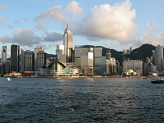
The Central and Western District located on northern part of Hong Kong Island is one of the 18 administrative districts of Hong Kong. It had a population of 243 266 in 2016. The district has the most educated residents with the second highest income and the third lowest population due to its relatively small size.

Nelson Street is a street in Mong Kok, Kowloon, Hong Kong. The street is 240 metres in length and runs in the east-west direction. It can be accessed from exits E1 and E2 of the Mong Kok Station. The section between Portland and Sai Yeung Choi South Street is closed to vehicular traffic.