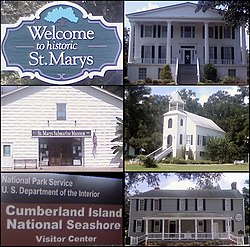
St. Marys is a city in Camden County, Georgia, United States, located on the southern border of Camden County on the St. Marys River in the state's Low Country. It had a population of 18,256 at the 2020 census, up from 17,121 at the 2010 census. It is part of the Kingsland, Georgia Micropolitan Statistical Area. The Florida border is just to the south across the river, Cumberland Island National Seashore is to the northeast, and Kingsland, Georgia, is to the west. Jacksonville, Florida, is 38 miles south, and Savannah, Georgia, is 110 miles north.

Capon Chapel, also historically known as Capon Baptist Chapel and Capon Chapel Church, is a mid-19th century United Methodist church located near to the town of Capon Bridge, West Virginia, in the United States. Capon Chapel is one of the oldest existing log churches in Hampshire County, along with Mount Bethel Church and Old Pine Church.

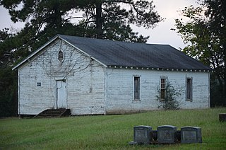
Glenville is an unincorporated community in Russell County, Alabama, United States which used to be in Barbour County. During the Civil War, Company "H" of the 15th Regiment Alabama Infantry was raised from Barbour and Dale counties and called the "Glenville Guards". The Glennville Historic District, containing the antebellum core of the community, is a historic district listed on the National Register of Historic Places in 1979.

The Savannah Historic District is a large urban U.S. historic district that roughly corresponds to the pre–Civil War city limits of Savannah, Georgia. The area was declared a National Historic Landmark District in 1966, and is one of the largest urban, community-wide historic preservation districts in the United States. The district was established in recognition of the Oglethorpe Plan, a unique model of urban planning begun in 1733 by James Oglethorpe at Savannah's founding and propagated during the first century of the city's growth.

St Mary's Ecumenical Church is a Church of England / Methodist Local Ecumenical Project in the village of Weaverham, Cheshire, England. The church is the parish church of Weaverham and Acton Bridge and part of the Methodist Northwich and Winsford Circuit. The vision of the church is to share the light and hope of Jesus with the local community. The church building is recorded in the National Heritage List for England as a designated Grade I listed building. It is an active Anglican parish church in the Diocese of Chester, the archdeaconry of Chester and the deanery of Middlewich.

The High Hills of Santee, sometimes known as the High Hills of the Santee, is a long, narrow hilly region in the western part of Sumter County, South Carolina. It has been called "one of the state's most famous areas". The High Hills of Santee region lies north of the Santee River and east of the Wateree River, one of the two rivers that join to form the Santee. It extends north almost to the Kershaw county line and northeasterly to include the former summer resort town of Bradford Springs. Since 1902 the town has been included in Lee County.

The South Britain Historic District encompasses the core of the unincorporated village of South Britain in Southbury, Connecticut, United States. The village arose in the 18th century as an industrial center serving the surrounding agricultural community, powered by the Pomperaug River, and rivalled the town center of Southbury in importance. The district was listed on the National Register of Historic Places in 1987.
The Simsbury Center Historic District is a 75-acre (30 ha) historic district located in the town center area of Simsbury, Connecticut. It encompasses seven blocks of Hopmeadow Street, as well as the cluster of commercial, civic, and residential buildings along Railroad, Station, and Wilcox Streets, and Phelps Lane. Although its oldest element is the cemetery, most of its buildings were built in the late 19th and early 20th century. It was listed on the National Register of Historic Places in 1996.
Winnona Park is a historic area in the southeast corner of the Atlanta, Georgia suburb of Decatur. It is listed as a historic district on the National Register of Historic Places, but it is not one of the City of Decatur's locally designated historic districts.
St. Francis Xavier Church and Newtown Manor House Historic District is the first county-designated historic district in Saint Mary's County, the "Mother County" of Maryland and is located in Compton, Maryland, near the county seat of Leonardtown. The district marks a location and site important in the 17th-century ecclesiastical history of Maryland, as an example of a self-contained Jesuit community made self-supporting by the surrounding 700-acre (2.8 km2) farm. The two principal historic structures were added to the National Register of Historic Places in 1972. Archaeological remains associated with the site date back to the early colonial period, mid-17th century.

Green Spring Valley Historic District is a national historic district near Stevenson in Baltimore County, Maryland, United States. It is a suburban area of Baltimore that acquires significance from the collection of 18th, 19th, and early 20th century buildings. The park-like setting retains a late 19th-early 20th century atmosphere. At the turn of the 20th century, the Maryland Hunt Cup and the Grand National Maryland steeplechase races were run over various parts of the valley. The Maryland Hunt Cup, which began as a competition between the Green Spring Valley Hunt and the Elkridge Hunt, traditionally started at Brooklandwood, the previous home of Charles Carrol of Carrollton with the finish across Valley Road at Oakdene, at that time the home of Thomas Deford, which remains a private residence

"Mount Winans" is a mixed-use residential, commercial and industrial neighborhood in the southwestern area of the City of Baltimore in Maryland. Its north, south and east boundaries are marked by the various lines of track of the CSX Railroad. In addition, Hollins Ferry Road running to the south towards suburban Baltimore County in the southwest and further connecting with adjacent Anne Arundel County to the southeast, draws its western boundary.

Solomon Wesley United Methodist Church is a historic church at 291-B Davistown Road / Asyla Road in the Blackwood section of Gloucester Township, Camden County, New Jersey, United States.

Mount Zion African Methodist Episcopal Church and Mount Zion Cemetery is a historic church and cemetery located at 172 Garwin Road in Woolwich Township, New Jersey, United States. The church was a stop on the Greenwich Line of the Underground Railroad through South Jersey operated by Harriet Tubman for 10 years. The church provided supplies and shelter to runaway slaves on their way to Canada from the South. The church and cemetery were part of the early 19th-century free negro settlement sponsored by Quakers known as Small Gloucester.

The Midway Historic District consists of 20 acres (8.1 ha) encompassing the Midway Congregational Church and Cemetery, the Midway Museum and the Old Sunbury Road, at the intersection of U.S. 17 and Martin Road in Midway, Liberty County, Georgia. The Midway Congregational Church is a large historic wooden church built in 1792 to replace an earlier church building that had been burned by the British during the Revolutionary War. Its historic cemetery also dates from the 18th century. Notable Georgians buried in it include Governor and Congressman Nathan Brownson and early U.S. Senator John Elliott. It also contains the Stewart–Screven Monument, honoring two generals from the Continental Army. The Midway Museum is housed in a modern reconstruction of a typical 18th century raised cottage such as those that once existed in the area. The Old Sunbury Road section that runs past the district is a remnant of the road built during the early years of Georgia's statehood. On March 1, 1973, the Midway Historic District was added to the National Register of Historic Places.
Moscow Methodist Church and Cemetery is a historic landmark built in 1864 and added to the National Register in 2006. The former community of Moscow is located just outside the current city limits of Prescott, Arkansas. The area is on or near the old "Moscow-Camden Road", or "Wire Road" which ran between Moscow and Camden, Arkansas. As of 2016, the location was known as the junction of Nevada County Roads 23 and 260.

Old Pine Church, also historically known as Mill Church, Nicholas Church, and Pine Church, is a mid-19th century church located near to Purgitsville, West Virginia, United States. It is among the earliest extant log churches in Hampshire County, along with Capon Chapel and Mount Bethel Church.

City of Camden Historic District is a national historic district located at Camden, Kershaw County, South Carolina. The district encompasses 48 contributing buildings, 8 contributing sites, 2 contributing structures, and 3 contributing objects in Camden. The district is mostly residential but also include public buildings, a church, and a cemetery. Camden's architecture is classically inspired and includes examples of Federal, Greek Revival, and Classical Revival, in addition to cottage-type, Georgian, Charleston-type with modifications, and mansion-type houses. Several of the city's buildings were designed by architect Robert Mills. Notable buildings include the Kershaw County Courthouse (1826), U.S. Post Office, Camden Opera House and Clock Tower, Camden Powder Magazine, Trinity United Methodist Church, St. Mary's Catholic Church, Gov. Fletcher House, Greenleaf Villa, The First National Bank of Camden, and the separately listed Bethesda Presbyterian Church and Kendall Mill.

The City Hall Park Historic District encompasses one of the central economic, civic, and public spaces of the city of Burlington, Vermont. Centered on City Hall Park, the area's architecture encapsulates the city's development from a frontier town to an urban commercial center. The district was listed on the National Register of Historic Places in 1983.