Stewartstown, Pennsylvania | |
---|---|
Coordinates: 39°45′15″N76°35′35″W / 39.75417°N 76.59306°W | |
Country | United States |
State | Pennsylvania |
County | York |
Founded | 1767 |
Area | |
• Total | 0.84 sq mi (2.18 km2) |
• Land | 0.84 sq mi (2.18 km2) |
• Water | 0.00 sq mi (0.69 km2) |
Elevation | 870.1 ft (265.2 m) |
Population | |
• Total | 2,129 |
• Density | 2,525.50/sq mi (975.06/km2) |
Time zone | UTC-5 (Eastern (EST)) |
• Summer (DST) | UTC-4 (EDT) |
ZIP codes | 17363 |
FIPS code | 42-74104 |
Website | www.stewartstown.org |
Stewartstown is a borough that is located in York County, Pennsylvania, United States. The population was 2,125 at the time of the 2020 census. [3]
There were settlers in the Stewartstown area as early as 1750. This part of southern York County was claimed by both Maryland and Pennsylvania, and the boundary dispute was settled by the surveying of the Mason–Dixon Line in 1767.
By 1777, a road had been well established between York and Baltimore, and Stewartstown's main street of today lies along a portion of the road. Around 1812, a group of farmers set out to establish a town in south central Hopewell Township. The earliest buildings were several houses, a workshop for making furniture and wheels, a store, and a tavern. Anthony Stewart, owner of the workshop, served as the village clerk, and his shop became the main meeting place.
The village was first known as Meadstown, after Benedict Meads, owner of the tavern and the store. Later it became known as Mechanicsburg because of a large number of tradesmen who lived in the community. By 1828, the town had its own post office, and Stewart was appointed the first postmaster. There was already another Pennsylvania town named Mechanicsburg, so postal officials assigned the name "Guilford" to the community. Through the efforts of Anthony Stewart, with the help of Judge Adam Ebaugh, the Post Office Department changed the town's postmark to "Stewartstown" on March 24, 1832.
The Stewartstown Engine House, Stewartstown Railroad and Stewartstown Railroad Station are listed on the National Register of Historic Places. [4]
Stewartstown is located at 39°45′15″N76°35′35″W / 39.75417°N 76.59306°W (39.754106, -76.593181). [5]
According to the United States Census Bureau, the borough has a total area of 0.8 square miles (2.1 km2), all land.
Census | Pop. | Note | %± |
---|---|---|---|
1860 | 189 | — | |
1870 | 212 | 12.2% | |
1880 | 303 | 42.9% | |
1890 | 441 | 45.5% | |
1900 | 573 | 29.9% | |
1910 | 674 | 17.6% | |
1920 | 718 | 6.5% | |
1930 | 863 | 20.2% | |
1940 | 985 | 14.1% | |
1950 | 1,133 | 15.0% | |
1960 | 1,164 | 2.7% | |
1970 | 1,157 | −0.6% | |
1980 | 1,072 | −7.3% | |
1990 | 1,308 | 22.0% | |
2000 | 1,752 | 33.9% | |
2010 | 2,089 | 19.2% | |
2020 | 2,125 | 1.7% | |
2021 (est.) | 2,153 | [3] | 1.3% |
U.S. Decennial Census [6] |
As of the census [7] of 2000, there were 1,752 people, 678 households, and 513 families residing in the borough. The population density was 2,091.9 inhabitants per square mile (807.7/km2). There were 718 housing units at an average density of 857.3 per square mile (331.0/km2). The racial makeup of the borough was 96.69% White, 1.60% African American, 0.29% Native American, 0.46% Asian, 0.23% from other races, and 0.74% from two or more races. Hispanic or Latino of any race were 1.26% of the population.
There were 678 households, out of which 39.5% had children under the age of 18 living with them, 58.4% were married couples living together, 13.0% had a female householder with no husband present, and 24.2% were non-families. 21.2% of all households were made up of individuals, and 7.7% had someone living alone who was 65 years of age or older. The average household size was 2.58 and the average family size was 2.99.
In the borough the population was spread out, with 29.0% under the age of 18, 5.9% from 18 to 24, 35.8% from 25 to 44, 20.0% from 45 to 64, and 9.4% who were 65 years of age or older. The median age was 34 years. For every 100 females there were 95.8 males. For every 100 females age 18 and over, there were 93.5 males.
The median income for a household in the borough was $50,000, and the median income for a family was $54,891. Males had a median income of $41,643 versus $28,500 for females. The per capita income for the borough was $22,095. About 2.9% of families and 4.1% of the population were below the poverty line, including 3.7% of those under age 18 and 8.8% of those age 65 or over.
Stewartstown is served by the South Eastern School District which provides a public education.
Strasburg is a borough in Lancaster County, Pennsylvania, United States. It developed as a linear village stretching approximately 2 miles (3 km) along the Great Conestoga Road, later known as the Strasburg Road. The population was 3,117 at the 2020 census.
Abbottstown is a borough in Adams County, Pennsylvania, United States. The population was 1,022 at the 2020 census.
New Oxford is a borough in Adams County, Pennsylvania, United States. The population was 1,868 at the 2020 census.
Athens is a borough in Bradford County, Pennsylvania, United States. It is part of Northeastern Pennsylvania and is located 2 miles (3 km) south of the New York state line on the Susquehanna and Chemung rivers. The population was 3,749 in 1900 and 3,796 in 1910. The population was 3,265 at the 2020 census. Athens is in a small area locally known as "The Valley", a group of four contiguous communities in Pennsylvania and New York: Waverly, New York; South Waverly, Pennsylvania; Sayre, Pennsylvania; and Athens. The Valley has a population near 30,000.
Lower Allen Township is a township in Cumberland County, Pennsylvania, United States. The population was 17,980 at the 2010 census.
Mechanicsburg is a borough in Cumberland County, Pennsylvania, United States. The borough is eight miles (13 km) west of Harrisburg. It is part of the Harrisburg–Carlisle metropolitan statistical area. As of the 2010 census, it had a population of 8,981. The 2020 census reported the population at 9,311.
Auburn is a borough in Schuylkill County, Pennsylvania, United States. The population was 663 at the 2020 census.
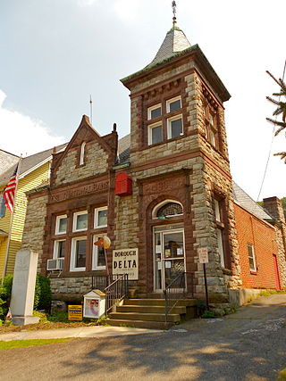
Delta is a borough in York County, Pennsylvania, United States, and one of the southernmost communities in Pennsylvania. The population was 706 at the 2020 census. It is served by the South Eastern School District which provides a public education.
East Prospect is a borough in York County, Pennsylvania, United States. The population was 932 at the 2020 census.
Fawn Grove is a borough in York County, Pennsylvania, United States. The population was 476 at the 2020 census. It is served by the South Eastern School District, which provides public education.
Hopewell Township is a township in York County, Pennsylvania, United States. The population was 5,267 at the 2020 census. It is served by the South Eastern School District, which provides public education.
Jacobus is a borough which is located in York County, Pennsylvania, United States. A suburb of York, the population was 1,829 at the time of the 2020 census.
North Codorus Township is a township in York County, Pennsylvania, United States. The population was 9,149 at the 2020 census.
Peach Bottom Township is a township in York County, Pennsylvania, 60 miles (97 km) south of Harrisburg. The population was 4,961 at the 2020 census.
Railroad is a borough in York County, Pennsylvania, United States. The population was two hundred fifty-nine at the time of the 2020 census.
Seven Valleys is a borough in York County, Pennsylvania, United States. The population was 480 at the 2020 census.
Shrewsbury Township is a township in York County, Pennsylvania, United States. The population was 6,651 at the 2020 census.
Winterstown is a borough in York County, Pennsylvania, United States. The population was 609 at the time of the 2020 census.
Yoe is a borough in York County, Pennsylvania, United States. The population was 1,058 at the time of the 2020 census.
Yorkana is a borough in York County, Pennsylvania, United States. The population was 236 at the 2020 census. It is a linear town, spread along Mt. Pisgah Road, which is called Main Street in town. The borough includes several dozen houses, two churches, a local fire company, and a few businesses.