The Cree are a North American Indigenous people. They live primarily in Canada, where they form one of the country's largest First Nations.

Northern Manitoba is a geographic and cultural region of the Canadian province of Manitoba. Originally encompassing a small square around the Red River Colony, the province was extended north to the 60th parallel in 1912. The region's specific boundaries vary, as "northern" communities are considered to share certain social and geographic characteristics, regardless of latitude.
The Opaskwayak Cree Nation is a First Nations band government located in Manitoba, Canada. The main OCN reserve is regarded as one of three distinct communities that comprise "The Pas area" in northern Manitoba, with the two others being the Town of The Pas and the Rural Municipality of Kelsey.
Deschambault Lake is a freshwater lake in the north-eastern region of the Canadian province of Saskatchewan. The identically-named community of Deschambault Lake resides on its shore. There are also four Indian reserves on the lake — Kimosom Pwatinahk 203, Mistik Reserve, Pisiwiminiwatim 207, and Muskwaminiwatim 225 — and a provincial recreation site.
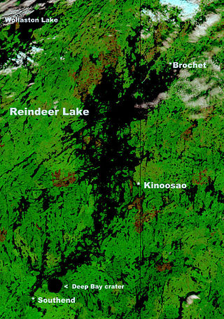
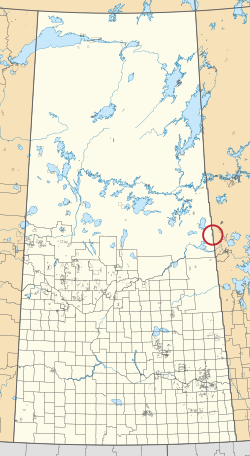
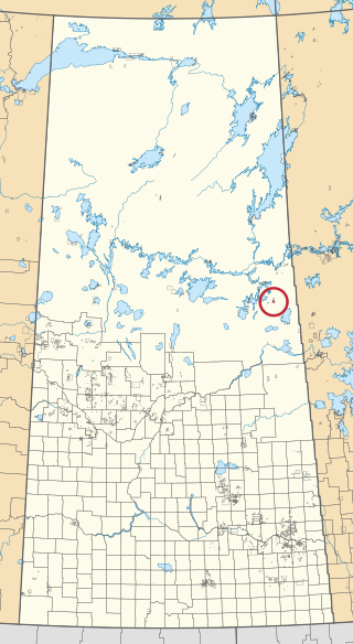
Kinoosao is an isolated community in northern Saskatchewan, Canada on the east side of Reindeer Lake. It is accessible by road only over Manitoba Provincial Road 394 and Saskatchewan Highway 994, coming from the closest town, over 95 kilometres (59 mi) away, Lynn Lake, Manitoba. Kinoosao is one of two communities in Saskatchewan accessible by road solely by first entering a neighbouring province (Manitoba), the other being Sturgeon Landing. It is 6.5 kilometres (4.0 mi) wide in size and is located in Division 18 in Saskatchewan. It is at 57.081993°N 102.01934°W.
The Peter Ballantyne Cree Nation is a Woodland Cree First Nation in northern Saskatchewan consisting of eight communities: Denare Beach, Deschambault Lake, Kinoosao, Pelican Narrows, Prince Albert (Kiskaciwan), Sandy Bay, Southend and Sturgeon Landing. The administrative centre of Peter Ballantyne Cree Nation is Pelican Narrows and the centralized government of the First Nation is located in Prince Albert, Saskatchewan.

Amisk Lake is a lake in the east-central part of the Canadian province of Saskatchewan, about 22 kilometres (14 mi) south-west of Flin Flon, Manitoba. 'Amisk' means beaver in Cree. Along the lake's shores is the community of Denare Beach, a provincial recreation site with lake access and camping, and prehistoric limestone crevices. Access to the lake and its amenities is from Highway 167. Amisk Lake was on an important fur trade route in the 18th century.
Marcel Colomb First Nation (MCFN), Band #328, is a First Nations Band of approximately 449 Registered Swampy Cree and Rocky Cree (Asinīskāwiyiniwak) located in the area of Lynn Lake, Manitoba, Canada.
Gambler First Nation is an Ojibway First Nations community in Manitoba. With a population of 334 members, it is one of the smallest indigenous communities in Manitoba.

Sturgeon Lake 154B is an Indian reserve of the Sturgeon Lake Cree Nation in Alberta, located within the Municipal District of Greenview No. 16. It is 4 kilometres south of Sturgeon Lake.

Cote 64 is an Indian reserve of the Cote First Nation in Saskatchewan. It is 16 kilometres (9.9 mi) west of the Manitoba border. In the 2016 Canadian Census, it recorded a population of 748 living in 220 of its 269 total private dwellings. In the same year, its Community Well-Being index was calculated at 51 of 100, compared to 58.4 for the average First Nations community and 77.5 for the average non-Indigenous community.

Keeseekoose 66-CA-04 is an Indian reserve of the Keeseekoose First Nation in Saskatchewan. It is about 39 kilometres (24 mi) east of Yorkton. In the 2016 Canadian Census, it recorded a population of 0 living in 0 of its 1 total private dwellings.

Keeseekoose 66-CA-06 is an Indian reserve of the Keeseekoose First Nation in Saskatchewan. It is about 54 kilometres (34 mi) east of Yorkton. In the 2016 Canadian Census, it recorded a population of 0 living in 0 of its 1 total private dwellings.

Ochapowace 71-26 is an Indian reserve of the Ochapowace Nation in Saskatchewan. It is about 13 kilometres (8.1 mi) north of Moosomin. In the 2016 Canadian Census, it recorded a population of 0 living in 0 of its 0 total private dwellings.

Sturgeon Lake 101 is an Indian reserve of the Sturgeon Lake First Nation in Saskatchewan. It is about 29 kilometres (18 mi) north-west of Prince Albert on the shores of Sturgeon Lake. In the 2016 Canadian Census, it recorded a population of 1174 living in 287 of its 293 total private dwellings. In the same year, its Community Well-Being index was calculated at 43 of 100, compared to 58.4 for the average First Nations community and 77.5 for the average non-Indigenous community.

Sturgeon Weir 184F is an Indian reserve of the Peter Ballantyne Cree Nation in Saskatchewan. It is adjacent to Sturgeon Weir 205 and about 55 kilometres (34 mi) south-east of Flin Flon. In the 2016 Canadian Census, it recorded a population of 81 living in 20 of its 26 total private dwellings. In the same year, its Community Well-Being index was calculated at 51 of 100, compared to 58.4 for the average First Nations community and 77.5 for the average non-Indigenous community.

The Thomas Morin Reserve is an Indian reserve of the Peter Ballantyne Cree Nation in Saskatchewan. It is within the city of Flin Flon.
Waskwaynikapik 228 is an Indian reserve of the Peter Ballantyne Cree Nation in Saskatchewan. It is along the course of the Sturgeon-Weir River and access is from Highway 106.
The Porcupine Provincial Forest is a protected boreal forest in Canada which covers the Porcupine Hills on the border of Saskatchewan and Manitoba.
Hanson Lake is a lake in the east-central part of the Canadian province of Saskatchewan in the boreal forest ecozone of Canada. The lake is irregularly shaped with many bays, islands, and channels as it was formed by glaciers during the last ice age. It is fed by multiple rivers and creeks from surrounding hills, smaller lakes, and muskeg. Hanson Lake's outflow is through a short river at the eastern end of the lake as it flows into the Sturgeon-Weir River, a tributary of the Saskatchewan River.