
The 2003 Atlantic hurricane season was a very active season with tropical cyclogenesis occurring before and after the official bounds of the season—the first such occurrence since the 1970 season. The season produced 21 tropical cyclones, of which 16 developed into named storms; seven of those attained hurricane status, of which three reached major hurricane status. The strongest hurricane of the season was Hurricane Isabel, which reached Category 5 status on the Saffir–Simpson hurricane scale northeast of the Lesser Antilles; Isabel later struck North Carolina as a Category 2 hurricane, causing $3.6 billion in damage and a total of 51 deaths across the Mid-Atlantic region of the United States.

The 2002 Atlantic hurricane season was a near-average Atlantic hurricane season. It officially started on June 1, 2002, and ended on November 30, dates which conventionally limit the period of each year when most tropical cyclones develop in the Atlantic Ocean. The season produced fourteen tropical cyclones, of which twelve developed into named storms; four became hurricanes, and two attained major hurricane status. While the season's first cyclone did not develop until July 14, activity quickly picked up: eight storms developed in the month of September. It ended early however, with no tropical storms forming after October 6—a rare occurrence caused partly by El Niño conditions. The most intense hurricane of the season was Hurricane Isidore with a minimum central pressure of 934 mbar, although Hurricane Lili attained higher winds and peaked at Category 4 whereas Isidore only reached Category 3. However, Lili had a minimum central pressure of 938 mbar.

The 1991 Atlantic hurricane season was the first season since 1984 in which no hurricanes developed from tropical waves, which are the source for most North Atlantic tropical cyclones. The hurricane season officially began on June 1, and ended on November 30. It was the least active in four years due to higher than usual wind shear across the Atlantic Ocean. The first storm, Ana, developed on July 2 off the southeast United States and dissipated without causing significant effects. Two other tropical storms in the season – Danny and Erika – did not significantly affect land. Danny dissipated east of the Lesser Antilles, and Erika passed through the Azores before becoming extratropical. In addition, there were four non-developing tropical depressions. The second depression of the season struck Mexico with significant accompanying rains.

The 2006 Atlantic hurricane season was the least active in the basin since 1997, with nine named storms as well as an additional unnamed tropical storm identified by the National Hurricane Center. 2006 was the first season since 2001 in which no hurricanes made landfall in the United States, and was the first since 1994 in which no tropical cyclones formed during October. Following the intense activity of 2003, 2004, and 2005, forecasters predicted that the 2006 season would be only slightly less active. Instead, it turned out to be a below average season, as activity was slowed by a rapidly forming moderate El Niño event, the presence of the Saharan Air Layer over the tropical Atlantic, and the steady presence of a robust secondary high-pressure area to the Azores High centered on Bermuda. There were no tropical cyclones after October 2.

The 2007 Atlantic hurricane season was the first season since 2003 to feature tropical activity both before and after the official bounds of the season. There were an above-average number of named storms during the season – 15, however many storms were weak and short-lived. Despite the predominance of weak systems, this was the first season on record to feature more than one Category 5 landfalling hurricane. This would not happen again until 2017. It produced 17 tropical cyclones, 15 tropical storms, six hurricanes, and two major hurricanes. It officially started on June 1 and ended on November 30, dates which conventionally delimit the period during which most tropical cyclones form in the Atlantic Ocean, although as shown by Subtropical Storm Andrea and Tropical Storm Olga in early May and early December, respectively, the formation of tropical cyclones is possible at any time of the year. The first system, Subtropical Storm Andrea, developed on May 9, while the last storm, Tropical Storm Olga, dissipated on December 13. The most intense hurricane, Dean, was, at the time, the third most intense landfalling Atlantic storm on record. It was the second on record in which an Atlantic hurricane, Felix, and an eastern Pacific hurricane, Henriette, made landfall on the same day. September had a then record-tying eight storms, until it was surpassed in 2020. However, the strengths and durations of most of the storms were low.

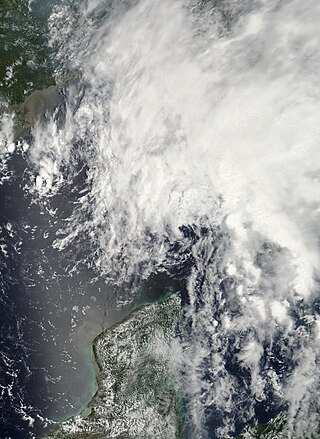
Hurricane Gabrielle was a North Atlantic hurricane that caused flooding in both Florida and Newfoundland in September 2001. It developed in the Gulf of Mexico on the same day as the September 11 attacks; after the attacks, flights were canceled nationwide for two days, and when Gabrielle struck Florida on September 14, it caused a day of additional cancellations. The storm moved ashore with winds of 70 mph (110 km/h) near Venice, a city located south of the Tampa Bay area. The combination of the winds and heavy rainfall, which peaked at 15.1 in (380 mm) in Parrish, left 570,000 customers without power along the west coast and 126,000 customers without power on the east coast. The storm caused about $230 million (2001 USD) in damage in Florida. In the Gulf of Mexico, high waves contributed to two deaths, one of which was indirect; there was also a death due to flooding in Winter Haven.

Tropical Storm Alberto was the first tropical storm of the 2006 Atlantic hurricane season. Forming on June 10 in the northwestern Caribbean, the storm moved generally to the north, reaching a maximum intensity of 70 mph (110 km/h) before weakening and moving ashore in the Big Bend area of Florida on June 13. Alberto then moved through eastern Georgia, North Carolina, and Virginia as a tropical depression before becoming extratropical on June 14.

Hurricane Kyle was the fifth-longest-lived Atlantic tropical or subtropical cyclone on record. The eleventh named storm and third hurricane of the 2002 Atlantic hurricane season, Kyle developed as a subtropical cyclone on September 20 to the east-southeast of Bermuda. Looping westward, it transitioned into a tropical cyclone and became a hurricane on September 25. For the next two weeks, Kyle tracked generally westward, oscillating in strength several times because of fluctuations in environmental conditions. On October 11, the cyclone turned northeastward and made landfalls near Charleston, South Carolina, and Long Beach, North Carolina, at tropical storm status. After lasting as a cyclone for 22 days, Kyle dissipated on October 12 as it was absorbed by an approaching cold front.

Hurricane Florence was the first North Atlantic hurricane to produce hurricane-force winds on the island of Bermuda since Hurricane Fabian in September 2003. The seventh tropical storm and second hurricane of the 2006 Atlantic hurricane season, Florence developed from a tropical wave in the eastern Atlantic Ocean on September 3. Due to unfavorable conditions, the system failed to organize initially, and as a result, the storm grew to an unusually large size. After several days, Florence encountered an area of lesser wind shear and intensified into a hurricane on September 10. It passed just west of Bermuda while recurving northeastward, and on September 13 it transitioned into an extratropical cyclone.
Tropical Storm Barry was a rapidly forming tropical cyclone that made landfall on Florida, United States, in early June 2007. The second named storm of the 2007 Atlantic hurricane season, Barry developed from a trough of low pressure in the southeastern Gulf of Mexico on June 1. It tracked rapidly northeastward, reaching peak winds of 60 mph (97 km/h) before weakening and making landfall near Tampa Bay as a tropical depression. Barry quickly lost tropical characteristics after wind shear removed much of the convection, and early on June 3, it completed the transition into an extratropical cyclone. The extratropical remnants tracked up the East Coast of the United States, and were absorbed by a larger extratropical cyclone on June 5.

Hurricane Olga was the fifteenth named storm and ninth hurricane of the 2001 Atlantic hurricane season. It was notable as it was the largest tropical cyclone by diameter of gale-force winds on record in the Atlantic at the time. Hurricane Olga formed as a subtropical cyclone on November 24. After acquiring tropical characteristics later that day, Olga meandered westward, and eventually reached hurricane status on November 26. Olga peaked as a 90 mph (140 km/h) Category 1 hurricane before the storm turned southwestward and weakening back into a tropical storm. On November 30 it deteriorated further to a tropical depression, although it re-intensified two days later to tropical storm intensity. Olga then dissipated as a tropical cyclone on December 4 east of the Bahamas. Its damaging effects were limited to ships at sea. The cyclone's remnants produced heavy rainfall across the Bahamas and Florida. It was a relatively rare storm to exist in December, which is outside of the normal Atlantic hurricane season.

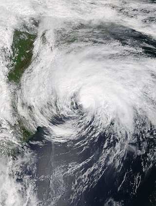
Tropical Storm Gabrielle was a short-lived tropical cyclone that passed over North Carolina before tracking out to sea. The seventh named storm of the 2007 Atlantic hurricane season, Gabrielle developed as a subtropical cyclone on September 8 about 385 miles (620 km) southeast of Cape Lookout, North Carolina. Unfavorable wind shear impacted the storm for much of its duration, although a temporary decrease in the shear allowed the cyclone to become a tropical storm. On September 9, Gabrielle made landfall at Cape Lookout National Seashore in the Outer Banks of North Carolina with winds of 60 mph (97 km/h). Turning to the northeast, the storm quickly weakened and dissipated on September 11.

Hurricane Noel was a deadly tropical cyclone that carved a path of destruction across the Atlantic Ocean from the Caribbean Sea to Newfoundland in late October 2007. The sixteenth tropical depression, fourteenth named storm, and the sixth hurricane of the 2007 Atlantic hurricane season, Noel formed on October 27 from the interaction between a tropical wave and an upper-level low in the north-central Caribbean. It strengthened to winds of 60 mph (97 km/h) before making landfall on western Haiti and the north coast of eastern Cuba. Noel turned northward, and on November 1, it attained hurricane status. The hurricane accelerated northeastward after crossing the Bahamas, and on November 2, it transitioned into an extratropical cyclone.

Tropical Storm Olga was an off-season tropical cyclone that impacted the Greater Antilles. The fifteenth named storm of the 2007 Atlantic hurricane season, Olga developed from a low developed east of the northernmost Lesser Antilles. It slowly acquired tropical characteristics, and late on December 10, the NHC declared it Subtropical Storm Olga while just north of Puerto Rico. It was the first post-season storm since Tropical Storm Zeta in the 2005 season, making the 2007 season one of the few with activity both before and after the official bounds of the hurricane season. Olga was only one of a few out of season tropical cyclones to make landfall. The storm made landfall on December 11 on the eastern tip of the Dominican Republic. Later that evening, Olga transitioned into a tropical storm just after making landfall. Olga tracked over Hispaniola and emerged in the Caribbean Sea. Strong wind shear and dry air caused Olga to weaken into a remnant low early on December 13.

Hurricane Bertha was the longest-lived Atlantic tropical cyclone on record during July, as well as the furthest east system to attain tropical storm intensity during the month. The second named storm, first hurricane, and first major hurricane of the active 2008 season, Bertha developed into a tropical depression on July 3 from a tropical wave that departed western Africa two days prior. On a west-northwest to northwest track, the depression intensified into Tropical Storm Bertha six hours formation and ultimately attained hurricane intensity on July 7. A period of rapid deepening brought the cyclone to its peak as a Category 3 hurricane with winds of 125 mph (205 km/h) late that afternoon. Changes in wind shear and the storm's internal structure allowed Bertha to fluctuate in intensity over the next week as it passed very near Bermuda, but a track over cooler waters eventually caused the system to become an extratropical cyclone by July 20. It continued northeast and was absorbed by another low near Iceland the following day. Rough surf propelled by Bertha killed three people along the East Coast of the United States; hundreds of other swimmers were injured and/or required rescuing. In Bermuda, some streets were flooded and strong gusts cut power to approximately 7,500 homes; only minor damage was observed.

Tropical Storm Cristobal was a strong tropical storm that paralleled the East Coast of the United States, traveling from Florida to Nova Scotia. The third named storm of the 2008 Atlantic hurricane season, Cristobal formed on July 19 from a trough of low pressure off the Southeast U.S. Coast. In a marginally favorable environment, it attained minimal tropical storm status later that day. The storm remained offshore, and peaked as a strong tropical storm on July 21 while it passed east of Cape Hatteras. It accelerated northeast parallel to the East Coast and became extratropical on July 23 near Nova Scotia. Because it was a weak storm and never made landfall, Cristobal's effects were mostly limited to moderate rainfall. The storm dropped 3.43 in (87 mm) of rain in Wilmington, North Carolina, where minor flooding was reported. Additionally, the extratropical remnants contributed to rainfall on Nova Scotia which caused some street and basement flooding.

Tropical Storm Beryl was the strongest off-season Atlantic tropical cyclone on record to make landfall in the United States. The second tropical cyclone of the 2012 Atlantic hurricane season, Beryl developed on May 26 from a low-pressure system offshore North Carolina. Initially subtropical, the storm slowly acquired tropical characteristics as it tracked across warmer sea surface temperatures and within an environment of decreasing vertical wind shear. Late on May 27, Beryl transitioned into a tropical cyclone less than 120 miles (190 km) from North Florida. Early the following day, the storm moved ashore near Jacksonville Beach, Florida, with peak winds of 65 mph (100 km/h). It quickly weakened to a tropical depression, dropping heavy rainfall while moving slowly across the southeastern United States. A cold front turned Beryl to the northeast, and the storm became extratropical on May 30.

Tropical Storm Ana was the first named storm of the 2015 Atlantic hurricane season. A pre-season system, it became the earliest United States–landfalling tropical cyclone on record. It developed as a subtropical cyclone from a non-tropical low north of the Bahamas, and intensified to attain peak winds of 60 mph (97 km/h) before transitioning into a fully tropical cyclone early on May 9. Sustained in part by the warm waters of the Gulf Stream, Ana made landfall along the northeast coast of South Carolina early the next morning. Overall, damage from the storm was minor. Heavy rainfall and gusty winds affected parts of the Carolinas, and some vulnerable beaches endured coastal flooding and several feet of erosion. Gusty winds damaged trees and powerlines, causing sporadic power outages, and a weak tornado was reported in association with Ana. In North Carolina, two deaths—one direct and one indirect—were attributed to the storm.
Tropical Storm Arthur was a strong off-season tropical cyclone that impacted the East Coast of the United States in May 2020. The first of thirty-one depressions and thirty different named storms of the extremely active 2020 Atlantic hurricane season, Arthur marked the record sixth consecutive year in the Atlantic basin with a tropical cyclone forming before June. It was one of two off-season storms in the season, alongside short-lived Tropical Storm Bertha. Arthur originated from a front that stalled over the Straits of Florida on May 10, which slowly drifted south for two days. The system became a tropical depression on May 16 north of The Bahamas. A day later, the system intensified into a tropical storm and was named Arthur. Arthur gradually intensified while tracking towards the Outer Banks of North Carolina, attaining its peak intensity with maximum 1-minute sustained winds of 60 mph (97 km/h) and a minimum central pressure of 990 mbar (29 inHg) on May 19, before skirting the region and becoming an extratropical cyclone. The cyclone then accelerated towards Bermuda and dissipated on May 21.

Hurricane Epsilon was a strong tropical cyclone that affected Bermuda, and parts of North America and Western Europe. The twenty-seventh tropical or subtropical cyclone, twenty-sixth named storm, eleventh hurricane, and fourth major hurricane of the extremely-active 2020 Atlantic hurricane season, Epsilon had a non-tropical origin, developing from an upper-level low off the East Coast of the United States on October 13. The low gradually organized, becoming Tropical Depression Twenty-Seven on October 19, and six hours later, Tropical Storm Epsilon. The storm executed a counterclockwise loop before turning westward, while strengthening. On October 20, Epsilon began undergoing rapid intensification, becoming a Category 1 hurricane on the next day, before peaking as a Category 3 major hurricane on October 22, with maximum 1-minute sustained winds of 115 mph (185 km/h) and a minimum central pressure of 952 millibars (28.1 inHg). This made Epsilon the easternmost major hurricane this late in the calendar year, as well as the strongest late-season major hurricane in the northeastern Atlantic, and the fastest recorded case of a tropical cyclone undergoing rapid intensification that far northeast that late in the hurricane season. Afterward, Epsilon began to weaken as the system turned northward, with the storm dropping to Category 1 intensity late that day. Epsilon maintained its intensity as it moved northward, passing to the east of Bermuda. On October 24, Epsilon turned northeastward and gradually accelerated, before weakening into a tropical storm on the next day. On October 26, Epsilon transitioned into an extratropical cyclone, before being absorbed by another larger extratropical storm later that same day.


