Related Research Articles

Hueco Tanks is an area of low mountains and historic site in El Paso County, Texas, in the United States. It is located in a high-altitude desert basin between the Franklin Mountains to the west and the Hueco Mountains to the east. Hueco is a Spanish word meaning hollows and refers to the many water-holding depressions in the boulders and rock faces throughout the region. Due to the unique concentration of historic artifacts, plants and wildlife, the site is under protection of Texas law; it is a crime to remove, alter, or destroy them.

Pictograph Cave is an area of three caves located 5 miles (8.0 km) south of Billings, Montana, United States, preserved and protected in the 23-acre (9.3 ha) Pictograph Cave State Park.

The Burro Flats site is a painted cave site located near Burro Flats, in the Simi Hills of eastern Ventura County, California, United States. The Chumash-style "main panel" and the surrounding 25-acres were listed on the National Register of Historic Places in 1976, with a boundary decrease in 2020. The main panel includes dozens of pictographs in a variety of colors. The cave is in the mountains, near the bi-lingual Chumash/Fernandeno village of Huwam/Jucjauynga. The Burro Flats painted cave and the rest of the former Santa Susana Field Laboratory are not accessible to the public.

This is a list of the National Register of Historic Places listings in Marion County, Arkansas.
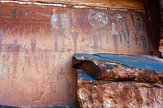
The Courthouse Wash Pictographs are a series of large pictographs created over a long period of time, located on a sheltered sandstone wall at the mouth of Courthouse Wash, Arches National Park in Grand County, Utah, United States, just north of Moab, that is listed on the National Register of Historic Places (NRHP).

Seminole Canyon State Park and Historic Site is a state park in the U.S. state of Texas. It is located off U.S. Route 90, east of the Pecos River High Bridge, 9 miles (14 km) west of Comstock in Val Verde County. The park is conducive to camping, biking, bird watching, back packing and archeological study. Cave art and archeological artifacts date back to the earliest human habitation in the area. The park is part of the larger Seminole Canyon Archeological District on the National Register of Historic Places.

Spider Cave, also known as Burnt Bluff Cave or 20DE3, is an archaeological site located on the Garden Peninsula near Fayette, Michigan. It was listed on the National Register of Historic Places in 1971.
Archeological Site CA-INY-134, in Inyo County, California near Olancha, California, is an archeological site that is listed on the National Register of Historic Places (NRHP). The site is located in the Coso Range 6 miles (9.7 km) northwest of Coso Hot Springs. It has also been known as Ayer's Rock Pictograph Site, as Bob Rabbit's Pictographs, as INY-134 and as INY-105. Prehistorically, it served as a camp and as a ceremonial site. The site includes three pictograph panels carved into a monolith. The pictographs are painted in a variety of colors and depict animal and human figures.
Indian Paintings is a historic archaeological site located near Maiden Spring, Tazewell County, Virginia. These pictographs are on a rock face high on Paint Lick Mountain. Stretched in a horizontal line along the irregular exposure is a series of simple images representing thunderbirds, human figures, deer, arrows, trees, and the sun, all painted in a red medium using iron oxide.
Brown Bluff is a rock art site in Washington County, Arkansas. The site consists of a prepared panel of sandstone extending some 80 metres (87 yd), on which have been painted pictographs in red. The site has been estimated to date to the Mississippian period, c. AD 1100–1600. The artwork is reminiscent of artwork found in the Arkansas River valley, and is one of the few places such artwork has been found in the western Ozark Mountains.

The Chugai' Pictograph Site is a prehistoric rock art site on the island of Rota in the Northern Mariana Islands. The rock art is located in a limestone cave on the southeastern side of the island, in the I'Chenchon Bird Sanctuary. It consists of a large panel, 185 feet (56 m) in length, of about 90 painted drawings, believed to be of late pre-contact origin. The site is accessed via a trail cut by the Japanese during the South Seas Mandate period.
The Talagi Pictograph Cave is a rock art site on the island of Guam. It is located on property owned by the government of Guam within the bounds of Andersen Air Force Base on the northern part of the island near Tarague Beach. The cave contains thirteen pictographs representing human figures, and a places where limestone mortar was used that is of prehistoric origin. Based on the characteristics of the figures, it is believed that they were probably the work of a single individual. It is one of a small number known rock art sites on the island.
The Mahlac Pictograph Cave is a rock art site on the island of Guam. It is located high in the southern mountains of the island, and contains more than 40 images, rendered in paints that are white, red, brown, and black. The art was carefully analyzed in 2011, and a radiocarbon date of c. 600 CE was obtained from a paint sample. The meaning of the art is a subject of debate.

Gadao's Cave, also known as Liyang Gadao, is a rock art site on the United States island of Guam. Located near the village of Inarajan, the cave is the site of a panel of approximately 50 Chamorro pictographs, painted with a mixture of coral lime and tree sap. The most unusual images are of two human stick figures that appear to be carrying things. It is not known who painted them or when, and what their significance is. The legendary chief of Inarajan Gadao is believed to be the creator of the cave's images.
The Cooper's Bluff Site is a prehistoric panel of pictographs in Searcy County, Arkansas. Located under a sheltering overhang, it measures about 4.5 by 1.8 metres, and is accompanied by a scatter of prehistoric Native American artifacts. It is estimated to have been painted about 1500 CE.
The Fox Pictograph is a prehistoric rock art site in Stone County, Arkansas. Located near the community of Fox, it is one of two documented examples of rock art depicting humans in the state. It is a stick figure, painted in red pigment, with an unusual depiction of ear ornaments. The figure is about 127 centimetres (50 in) in height.
The Pictograph Cave is a prehistoric rock art site near Mountain View, Arkansas. It consists of a panel of painted art, most of which is abstract wavy lines similar to art found at Petit Jean State Park. It is one of the furthest-removed expressions of this category of artwork from the Petit Jean area, and was listed on the National Register of Historic Places in 1982 for its information and research potential.
Archeological Site 3NW79 is a prehistoric pictograph site in the Ozark-St. Francis National Forest, in Newton County, Arkansas. It consists of a panel of twenty figures, set in a sheltered area. It is expected to contribute to the understanding of Mississippian cultures that lived in the area c. 1000-1500 CE.

Petit Jean State Park is the oldest state park in Arkansas. It is located in the central northern part of the state, in western Conway County, atop Petit Jean Mountain, a ridge between the Ozark and Ouachita Mountains. One of the features the park is noted for is prehistoric rock art, some of which is accessible to park visitors via its hiking trails. A total of twelve such sites have been listed on the National Register of Historic Places for their importance. Most of the rock art has been dated to about 1500 CE, and is not obviously associated with habitation sites or other sites bearing evidence of other Native American activities.
The King's Canyon Petroglyphs are a prehistoric rock art site near Clarksville, Arkansas. The site includes a panel petroglyphs, which include depictions of a sunburst motif and what look like turkey tracks. The latter is a particularly uncommon subject for rock art in this area.
References
- 1 2 "National Register Information System". National Register of Historic Places . National Park Service. July 9, 2010.
- ↑ "Image 140 (3MR0094)". University of Arkansas. Retrieved February 26, 2015.