The Chesapeake Bay is the largest estuary in the United States. The bay is located in the Mid-Atlantic region and is primarily separated from the Atlantic Ocean by the Delmarva Peninsula, including parts of the Eastern Shore of Maryland, the Eastern Shore of Virginia, and the state of Delaware. The mouth of the bay at its southern point is located between Cape Henry and Cape Charles. With its northern portion in Maryland and the southern part in Virginia, the Chesapeake Bay is a very important feature for the ecology and economy of those two states, as well as others surrounding within its watershed. More than 150 major rivers and streams flow into the bay's 64,299-square-mile (166,534 km2) drainage basin, which covers parts of six states and all of Washington, D.C.

Rappahannock County is a county located in the northern Piedmont region of the Commonwealth of Virginia, US, adjacent to Shenandoah National Park. As of the 2020 Census, the population was 7,348. Its county seat is Washington. The name "Rappahannock" comes from the Algonquian word lappihanne, meaning "river of quick, rising water" or "where the tide ebbs and flows." The county is included in the Washington-Arlington-Alexandria, DC-VA-MD-WV Metropolitan Statistical Area.

Chesapeake is an independent city in Virginia, United States. At the 2020 census, the population was 249,422, making it the second-most populous city in Virginia, the tenth largest in the Mid-Atlantic, and the 89th-most populous city in the United States.

The Patuxent River is a tributary of the Chesapeake Bay in the state of Maryland. There are three main river drainages for central Maryland: the Potomac River to the west passing through Washington, D.C., the Patapsco River to the northeast passing through Baltimore, and the Patuxent River between the two. The 908-square-mile (2,352 km2) Patuxent watershed had a rapidly growing population of 590,769 in 2000. It is the largest and longest river entirely within Maryland, and its watershed is the largest completely within the state.
Naval Weapons Station Yorktown is a United States Navy base in York County, James City County, and Newport News in the Hampton Roads region of Virginia. It provided a weapons and ammunition storage and loading facility for ships of the United States Atlantic Fleet, and more recently, for those from the Fleet Forces Command.
Berkley was an incorporated town in Norfolk County, Virginia. Chartered by an Act of Assembly in 1890, the Town of Berkley was located directly across the Eastern Branch Elizabeth River from the City of Norfolk in the South Hampton Roads area.
Norge is an unincorporated community in James City County, Virginia, United States.

Lyon Village is a neighborhood and urban village in Arlington County, Virginia, along Langston Boulevard. It adjoins Arlington County's government center, and is approximately one mile west of Rosslyn and less than a mile north of Clarendon, of which it is sometimes considered a sub-neighborhood, as is Cherrydale, the mostly residential district immediately west of Lyon Village.

The Lower Basin Historic District is a national historic district located in Lynchburg, Virginia. The district defines a commercial and industrial warehouse area located between the downtown commercial area to the south and the James River waterfront to the north. The district contains a variety of mostly late 19th- and early 20th-century, multi-story, brick warehouses and factories, two-to-three-story brick commercial buildings, and a number of structures associated with the James River and Kanawha Canal and the Norfolk and Western and Chesapeake and Ohio Railways. The district is named for a wide basin of the canal that once extended between Ninth Street and Horseford Road, and contains 60 contributing buildings, two contributing structures, and one contributing object-a monument commemorating the site of 18th-century Lynch's Ferry.

Luke Mountain Historic District is a national historic district located near Covington, Alleghany County, Virginia. The district encompasses 12 contributing buildings, 4 contributing sites, 6 contributing structures, and 1 contributing object on Luke Mountain overlooking the city of Covington. It includes three high style dwellings all built for members of the Luke family, the earliest of which was built in 1919. Other contributing resources include the former farm manager's house; agricultural barns, shelters, greenhouses, and storage buildings; and domestic structures such as swimming pools and garages. Other landscape features include a winding entrance drive, a pair of gateposts, stone-lined drainage ditches, a concrete bridge/culvert over Lindsay Glen Run, a reservoir and private water system, terraced fields, pastureland, formal garden spaces, and walking/hiking paths.

Centreville–Fentress Historic District is a national historic district located at Chesapeake, Virginia. The district encompasses 24 contributing buildings and 10 contributing structures in a rural farming community that developed a small commercial core. It was developed starting in the 1880s, with the addition of the Norfolk and Elizabeth City Railroad link to the Albemarle and Chesapeake Canal. Notable resources include the Fentress House, Colonial Revival style Centerville Baptist Church (1925), New Burfoot House (1925), Queen Anne style George Jackson House (1890), the Norfolk and Elizabeth City, NC Railroad Tracks, and a 1920 commercial building.
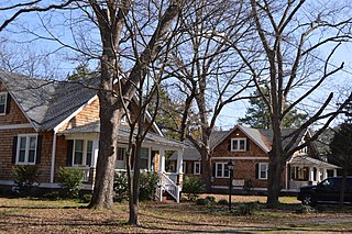
Oaklette Historic District is a national historic district located at Chesapeake, Virginia. The district encompasses 30 contributing buildings and 1 contributing object in an early-20th century planned streetcar suburb of Norfolk, Virginia. It is a primarily residential district that developed starting about World War I. The dwellings include representative examples of the Colonial Revival and Bungalow styles. Notable buildings include the Savage House (1915-1919), Pascal Paxson House (1901), George Wesley Jones House (1925), Samuel Paxson House (1906), Colonna Estate Caretaker's House (1925), and the Baker House (1910).
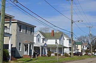
South Norfolk Historic District is a national historic district located at Chesapeake, Virginia. The district encompasses 668 contributing buildings and 1 contributing site in what started as a planned community of Norfolk County, Virginia and grew to become an independent city. South Norfolk was never part of Norfolk, Virginia. In fact, the two cities are separated by the Eastern Branch of the Elizabeth River. South Norfolk is a primarily residential district that was developed between 1890 and 1930. The dwellings include representative examples of the Colonial Revival, Stick Style, and Queen Anne styles. The district also includes several churches, a school, a park, and a small local business district.

The Chesterfield Heights Historic District is a national historic district located at Norfolk, Virginia. It encompasses 402 contributing buildings, 1 contributing site, and 1 contributing structure in a cohesive residential neighborhood located just to the northeast of downtown Norfolk. It was platted in 1904, and largely developed between 1915 and 1950. There are notable examples of Queen Anne and Italianate style residential architecture. Notable non-residential buildings include the St. Luke's Holiness Church of Christ's Disciples, Monticello Baptist Church (1925), and the Garrett Community Church (1940).

Saint Mary's Catholic Cemetery is a historic cemetery and national historic district located at Norfolk, Virginia. It encompasses six contributing structures and one contributing object in cemetery established in 1854 to serve the Roman Catholic communities of Norfolk, Virginia Beach, and Chesapeake. The cemetery was established by the pastor of St. Mary's Church of Norfolk. Notable features include the large bronze crucifix erected around 1922 in honor of Catholic servicemen who served in World War I and six family mausoleums.
Tyden Farm No. 6 Farmstead Historic District is an agricultural historic district located east of Dougherty, Iowa, United States. It was listed on the National Register of Historic Places in 2009.

Farm No. 1, Iowa Men's Reformatory, also known as the West Farm, is located west of Anamosa, Iowa, United States. It was listed as a historic district on the National Register of Historic Places in 1992. At the time of its nomination the district consisted of 10 resources, including seven contributing buildings, and three non-contributing buildings. When the property for the reformatory was acquired by the State of Iowa in 1872 it included 61 acres (25 ha) of farmland. Farming at the facility did not become a significant enterprise here until the turn of the 20th century. Before then the prisoners maintained a vegetable garden within the walls, and they raised sixty-five hogs. The state bought 80.31 acres (32.50 ha) of land in 1904 for farming operations and built a hog house and a stone barn, both are no longer extant. Minimum security prisoners did the farm work. The historic buildings were built between 1912 and 1939. They are all stone structures built in a simplified Romanesque Revival style. The influence of the style is found in the "heavy massing, texture of the stone, and the window, door, and corner treatments." The buildings were built for the following uses: South barn, barn granary (1915), root cellar (1919), North barn, slaughter house (1921-1922), processing plant (1922), and the seed house, dining hall, cold frame (1939).

The Johnson County Poor Farm and Asylum Historic District is a nationally recognized historic district located in Iowa City, Iowa, United States. It was listed on the National Register of Historic Places in 2014. At the time of its nomination it consisted of 11 resources, which included three contributing buildings, two contributing sites, four contributing structures and two non-contributing buildings. It also includes the First Johnson County Asylum, which was individually listed on the National Register. The remaining buildings and structures are agricultural in nature, and were built from the late 19th century to the early 20th century.
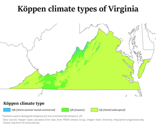
Climate change in Virginia encompasses the effects of climate change, attributed to man-made increases in atmospheric carbon dioxide, in the U.S. state of Virginia.
The Meyers Farmstead Historic District, also known as the Jacob E. and Amanda Meyers Farm and the John B. and Ella Meyers Farm, is an agricultural historic district located in Lisbon, Iowa, United States. It was listed on the National Register of Historic Places in 2021. At the time of its nomination it consisted of six resources, which included two contributing buildings, two contributing structures, and two contributing objects. The historic buildings include a heavy timber frame Pennsylvania banked barn (1870s) and a feeder/hay barn. The historic structures include a combination corn crib/hog house (1880s) and a concrete silo. The contributing objects include a concrete watering trough and water pump and a metal gateway. The farmhouse is also extant but was separated from the rest of the farm buildings when South Jefferson Street was extended in 2002. That separation and the modifications made to it over the years has led to its loss of historical integrity