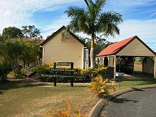
St Kilda is a rural locality in the Bundaberg Region, Queensland, Australia. In the 2021 census, St Kilda had a population of 99 people.
Victory Heights is a rural residential locality in the Gympie Region, Queensland, Australia. In the 2021 census, Victory Heights had a population of 486 people.
Buxton is a rural locality in the Bundaberg Region, Queensland, Australia. In the 2021 census, the locality of Buxton had a population of 507 people.
Blue Mountain Heights is a residential locality in the Toowoomba Region, Queensland, Australia. In the 2021 census, Blue Mountain Heights had a population of 988 people.
Prince Henry Heights is a residential locality on the outskirts of Toowoomba in the Toowoomba Region, Queensland, Australia. In the 2021 census, Prince Henry Heights had a population of 600 people.

Redwood is a rural locality on the outskirts of Toowoomba in the Toowoomba Region, Queensland, Australia. In the 2021 census, Redwood had a population of 159 people.
South Bingera is a rural residential locality in the Bundaberg Region, Queensland, Australia. In the 2021 census, South Bingera had a population of 674 people.

Millbank is a mixed-use suburb in the Bundaberg Region, Queensland, Australia. In the 2021 census, Millbank had a population of 2,499 people.
Thabeban is a suburb of Bundaberg in the Bundaberg Region, Queensland, Australia. In the 2021 census, Thabeban had a population of 2,971 people.
Avenell Heights is a southern suburb of Bundaberg in the Bundaberg Region, Queensland, Australia. In the 2021 census, Avenell Heights had a population of 5,028 people.
Drinan is a rural locality in the Bundaberg Region, Queensland, Australia. In the 2021 census, Drinan had a population of 135 people.

Fairymead is a coastal locality in the Bundaberg Region, Queensland, Australia. In the 2021 census, Fairymead had a population of 28 people.
Pine Creek is a rural locality in the Bundaberg Region, Queensland, Australia. In the 2021 census, Pine Creek had a population of 258 people.
Ashfield is a mixed residential and rural locality in the Bundaberg Region, Queensland, Australia. In the 2021 census, Ashfield had a population of 1,152 people.

Kensington is a mixed-use locality in the Bundaberg Region, Queensland, Australia. Traditionally a rural area on the south-western outskirts of Bundaberg, there is increasing commercial and residential development within the locality. In the 2021 census, Kensington had a population of 722 people.
Calavos is a rural locality in the Bundaberg Region, Queensland, Australia. In the 2021 census, Calavos had a population of 359 people.
Duingal is a locality in the Bundaberg Region, Queensland, Australia. In the 2021 census, Duingal had a population of 70 people.
Isis River is a locality in the Bundaberg Region, Queensland, Australia. In the 2021 census, Isis River had a population of 100 people.
Abbotsford is a rural locality in the Bundaberg Region, Queensland, Australia. In the 2021 census, Abbotsford had a population of 20 people.
Moorland is a rural locality in the Bundaberg Region, Queensland, Australia. In the 2021 census, Moorland had a population of 284 people.


