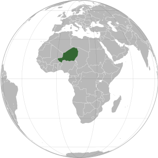
Niger or the Niger, officially the Republic of the Niger, is a landlocked country in West Africa. It is a unitary state bordered by Libya to the northeast, Chad to the east, Nigeria to the south, Benin and Burkina Faso to the southwest, Mali to the west, and Algeria to the northwest. It covers a land area of almost 1,270,000 km2 (490,000 sq mi), making it the largest landlocked country in West Africa and the second largest landlocked nation in Africa behind Chad. Over 80% of its land area lies in the Sahara. Its predominantly Muslim population of about 25 million lives mostly in clusters in the south and west of the country. The capital Niamey is located in Niger's southwest corner.

The Tuareg people are a large Berber ethnic group that principally inhabit the Sahara in a vast area stretching from far southwestern Libya to southern Algeria, Niger, Mali, and Burkina Faso. Traditionally nomadic pastoralists, small groups of Tuareg are also found in northern Nigeria.

The regions of Niger are subdivided into 63 departments. Before the devolution program on 1999–2005, these departments were styled arrondissements. Confusingly, the next level up (regions) had, before 2002-2005 been styled departments. Prior to a revision in 2011, there had been 36 departments. A draft law in August 2011 would expand that number to 63. Until 2010, arrondissements remained a proposed subdivision of departments, though none were used. The decentralisation process, begun in the 1995-1999 period replaced appointed Prefects at Departmental or Arrondissement level with elected councils, first elected in 1999. These were the first local elections held in the history of Niger. Officials elected at commune level are then selected as representatives at Departmental, regional, and National level councils and administration. The Ministry of Decentralisation was created to oversee this task, and to create a national consultative council of local officials.

Gao, or Gawgaw/Kawkaw, is a city in Mali and the capital of the Gao Region. The city is located on the River Niger, 320 km (200 mi) east-southeast of Timbuktu on the left bank at the junction with the Tilemsi valley.
Timia is a small town and commune in northern Niger, situated at an oasis in the Aïr Mountains, Agadez Region, Arlit Department. Visitors come to the Tuareg town to see a seasonal waterfall, a former French fort and the nearby ruined town of Assodé. As of 2012, the commune had a total population of 19,076 people.

From 1990 to 1995, a rebellion by various Tuareg groups took place in Niger and Mali, with the aim of achieving autonomy or forming their own nation-state. The insurgency occurred in a period following the regional famine of the 1980s and subsequent refugee crisis, and a time of generalised political repression and crisis in both nations. The conflict is one in a series of Tuareg-based insurgencies in the colonial and post-colonial history of these nations. In Niger, it is also referred to as the Second or Third Tuareg Rebellion, a reference to the pre-independence rebellions of Ag Mohammed Wau Teguidda Kaocen of the Aïr Mountains in 1914 and the rising of Firhoun of Ikazkazan in 1911, who reappeared in Mali in 1916. In fact the nomadic Tuareg confederations have come into sporadic conflict with the sedentary communities of the region ever since they migrated from the Maghreb into the Sahel region between the 7th and 14th centuries CE. Some Tuareg wanted an independent Tuareg nation to be formed when French colonialism ended. This, combined with dissatisfaction over the new governments, led some Tuareg in Northern Mali to rebel in 1963.

Tahoua is one of eight Regions of Niger. The capital of the region is the commune of Tahoua. The region covers 106,677 km².
In-Gall is a town in the Agadez Region, Tchirozerine Department of northeast Niger, with a year-round population of less than 500. Known for its oasis and salt flats, In-Gall is the gathering point for the Cure Salee festival of Tuareg and Wodaabe pastoralists to celebrate the end of the rainy season each September. During the festival, In-Gall's population grows to several thousand nomads, officials, and tourists. As of 2011, the commune had a total population of 47,170 people.
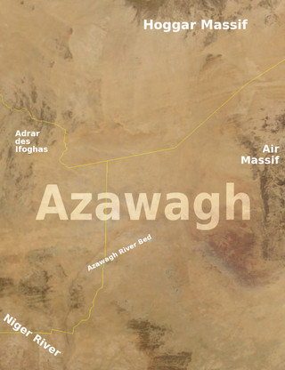
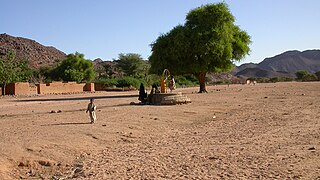
The Azawagh is a dry basin covering what is today the northwestern Niger, as well as parts of northeastern Mali and southern Algeria. The Azawagh is mainly made up of Sahelian and Saharan flatlands and has a population that is predominantly Tuareg, with some Arabic-speaking and Wodaabe minorities and a recent influx of Hausa and Zarma.
Ouallam is a town around 90 km north of Niamey in southwestern Niger. It is the capital of Ouallam Department, one of four departments in the Tillabéri Region.
Bani-Bangou is a town in southwestern Niger, in rural northern Ouallam Department, Tillabéri Region. It is the capital of the rural commune of Bani-Bangou. On the main highway from Ouallam on the route to the Malian border town of Andéramboukane. It is 135 km northeast of Ouallam and 70 km by road from Mali. It around 200 km cross country from Niamey. The town is the seat of a "Rural Commune" of the same name, one of four rural communes in the department. Nearby villages include Gorou, Bassikwana, and Tondi Tiyaro Kwara to the north; Koloukta and Dinara along the highway west; Ouyé to the southeast.
The following outline is provided as an overview of and topical guide to Niger:
Dabaga is a town and rural commune in the Agadez Region of northern Niger. The town is situated around 50 kilometers north of the regional capital, Agadez, on the main road leading north into the Aïr Mountains and the town of Elmeki. Like the nearby communities of Azel, Elmeki and Egandawel, Dabaga is an oasis in the Aïr Massif valleys, populated by both sedentary and semi-nomadic Tuaregs and small numbers of Hausa and other groups. According to the census 2012, Dabaga had a permanent population of 23,969, mostly families of Tuareg pastoralists, where the adult males traveled with their herds.

Tchintabaraden is a department of the Tahoua Region in Niger. Its capital lies at the city of Tchintabaraden. As of 2012, the department had a total population of 145,086 people.
Akoubounou, or Akabinu in the local Tin Sert language, is a village located in the west to the town of Abalak, in the Tahoua Region of Niger.
Bankilaré is a village and rural commune in Niger. Bankilaré commune, centered on the town of the same name, is in Téra Department, Tillabéri Region, in the northwestern corner of the country. The town lies 60 km north of Departmental capital Téra, and around the same distance from the Burkina Faso border and the Mali border. As of 2012, it had a population of 84,893.

Tassara is a village and rural commune in Niger.

Tesker or Tasker is a village and rural commune in Niger. As of 2012, it had a population of 37,132 people. It is the birthplace of musician Mamane Barka . The sparsely populated commune extends over a wide area and spans two major regions: the Sahel region in the south and the Sahara desert in the north. In the northeast, it rises up to a height of 710 metres (2,330 ft) at the Termit Massif. It is bordered by Fachi and Tabelot in the north, N'Gourti to the east, Alakoss, Kellé and N'Guelbély to the south and Tenhya to the west. The municipality is divided into 36 administrative villages, one traditional village, three hamlets, 29 camps and 144 watering places.
The Igdalen are a Berber people inhabiting northwestern Niger and parts of Mali and Algeria. They speak Tagdal, a mixed Tuareg–Songhay language. The Igdalen are closely related to Idaksahak people of eastern Mali and the Sawaq of Ingal in Niger, with whom they share a very similar language. Culturally, the Igdalen are often considered a Tuareg faction. In the past they have formed a sub-confederation with the Kel Fadey, Kel Ferwan and others in the Kel Ayr Tuareg confederation or Drum Group.

