
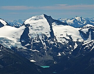
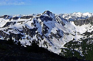
Mount Matier is a prominent 2,783-metre (9,131-foot) mountain summit located in the Coast Mountains, in Joffre Lakes Provincial Park, in southwestern British Columbia, Canada. It is the highest point of the Joffre Group, which is a subset range of the Coast Mountains. It is situated 26 km (16 mi) east of Pemberton, and 9 km (6 mi) northeast of Lillooet Lake. Its nearest higher peak is Mount Weart, 30 km (19 mi) to the southwest. The slopes of the mountain are covered by the Matier Glacier on the northwest, Anniversary Glacier on the northeast, Twin One Glacier on the southeast, and Hartzell Glacier to the south. Precipitation runoff from the peak drains into Joffre Creek and Twin One Creek, both tributaries of the Lillooet River.

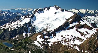
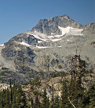
Joffre Peak is a 2,721-metre (8,927-foot) mountain summit located in the Coast Mountains, in Joffre Lakes Provincial Park, in southwestern British Columbia, Canada. It is the second-highest point of the Joffre Group, which is a subset of the Lillooet Ranges. It is situated 26 km (16 mi) east of Pemberton and 11 km (7 mi) northeast of Lillooet Lake. Joffre is more notable for its steep rise above local terrain than for its absolute elevation as topographic relief is significant with the summit rising 1,500 meters (4,920 ft) above Cayoosh Creek in 4 km (2.5 mi). The nearest higher peak is Mount Matier, 1.6 km (1 mi) to the south. The mountain's climate supports the Matier Glacier on the southwest slope, and the Anniversary Glacier on the southeast slope. Precipitation runoff from the peak drains into Joffre Creek and Cayoosh Creek which are both within the Fraser River watershed.
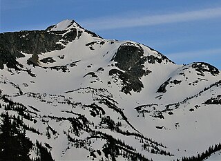
Slalok Mountain, originally known as Rex's Pillar, is a 2,653-metre (8,704-foot) mountain summit located in the Coast Mountains, in Joffre Lakes Provincial Park, in southwestern British Columbia, Canada. It is the third-highest point of the Joffre Group, which is a subset of the Lillooet Ranges. It is situated 24 km (15 mi) east of Pemberton, and 8 km (5 mi) northeast of Lillooet Lake. It is 4 km (2 mi) northeast of Duffey Peak and the nearest higher peak is Mount Matier, 1.9 km (1 mi) to the east. Precipitation runoff from the peak drains into Joffre Creek and Twin One Creek, both tributaries of the Lillooet River. The first ascent of the mountain was made in 1963 by C. Adam, T. Anderson, and G. Richardson. The mountain's name Slalok is the traditional name for the settlement of nearby Mount Currie. The name was officially adopted on June 11, 1979, by the Geographical Names Board of Canada. The mountain and its climate supports the Matier Glacier, Stonecrop Glacier, and Tszil Glacier on the northern slopes.
Cayoosh Mountain is a 2,561-metre (8,402-foot) mountain summit located in the Cayoosh Range in southwestern British Columbia, Canada. It is situated 22 km (14 mi) east-northeast of Pemberton, 12 km (7 mi) north-northeast of Lillooet Lake, and immediately north of Cayoosh Pass. Its nearest higher peak is Mount Marriott, 5.43 km (3 mi) to the north-northeast. Precipitation runoff from the peak drains into Cayoosh Creek and other tributaries of the Fraser River. The mountain's name was submitted by Karl Ricker, a mountaineer, and was officially adopted on January 23, 1979, by the Geographical Names Board of Canada.
Mount Spetch is a 2,579-metre (8,461-foot) mountain summit located in the Coast Mountains, in Joffre Lakes Provincial Park, in southwestern British Columbia, Canada. It is part of the Joffre Group, which is a subset of the Lillooet Ranges. It is situated 25 km (16 mi) east of Pemberton, midway between Mount Matier and Slalok Mountain, both one kilometre either side of Spetch. The mountain's name was submitted by Karl Ricker of the Alpine Club of Canada to honor Samuel W. Spetch, who operated the general store at Birken, and other businesses in Pemberton. The name was officially adopted on January 23, 1979, by the Geographical Names Board of Canada. The first ascent of the mountain was made in 1971 by J. Oswald and G. Walter. Precipitation runoff from the peak drains into Joffre Creek and Twin One Creek, both tributaries of the Lillooet River. The mountain and its climate supports the Matier Glacier on the northern slope.
Mount Hartzell is a 2,615-metre (8,579-foot) mountain summit located in the Coast Mountains, in Joffre Lakes Provincial Park, in southwestern British Columbia, Canada. It is part of the Joffre Group, which is a subset of the Lillooet Ranges. It is situated 25 km (16 mi) east of Pemberton, midway between Mount Matier and Mount Spetch, each a half kilometre either side of Hartzell. The mountain's name was submitted by Karl Ricker of the Alpine Club of Canada to honor Carl A. Hartzell, an early settler and postmaster at Pemberton. The name was officially adopted on January 23, 1979, by the Geographical Names Board of Canada. Precipitation runoff from the peak drains into Joffre Creek and Twin One Creek, both tributaries of the Lillooet River. The mountain and its climate supports the Hartzell Glacier on the southeast slope, and the Matier Glacier on the northern slope.

Mount Sampson is a 2,811-metre (9,222-foot) mountain summit located in the Thiassi Range of the Coast Mountains, in the Pemberton Valley of southwestern British Columbia, Canada. It is the highest point in the Thiassi Range. Sampson is situated 41 km (25 mi) northwest of Pemberton, and 21.5 km (13 mi) southeast of Mount Ethelweard, which is its nearest higher peak. Precipitation runoff from the peak drains into tributaries of the Lillooet and Hurley Rivers.
Mount Taylor is a 2,318-metre (7,605-foot) mountain summit located in the Coast Mountains, in Joffre Lakes Provincial Park, in southwestern British Columbia, Canada. It is part of the Joffre Group, which is a subset of the Lillooet Ranges. It is situated 21 km (13 mi) east of Pemberton, and 7 km (4 mi) northeast of Lillooet Lake. Its nearest higher peak is Slalok Mountain, 1.9 km (1 mi) to the east. Precipitation runoff from the peak drains into Joffre Creek, a tributary of the Lillooet River. The mountain's name was submitted by Karl Ricker of the Alpine Club of Canada to honor Ada C. Taylor, a Pemberton pioneer and the first nurse in that community. The toponym was officially adopted January 23, 1979, by the Geographical Names Board of Canada.

Tremor Mountain is a prominent 2,691-metre (8,829-foot) summit located in the Garibaldi Ranges of the Coast Mountains, in Garibaldi Provincial Park of southwestern British Columbia, Canada. It is the highest point of the Spearhead Range, which is a subset of the Garibaldi Ranges. It is situated 13 km (8 mi) southeast of Whistler, and 8.7 km (5 mi) south of Wedge Mountain, its nearest higher peak. Precipitation runoff from the south side of the peak as well as meltwater from the Platform Glacier drains into Fitzsimmons Creek which is a tributary of the Green River. Meltwater from the Tremor Glacier on the northwestern slope drains to Wedge Creek, and meltwater from the Shudder Glacier on the northeast slope drains into Billygoat Creek, a tributary of the Lillooet River. Tremor Mountain is often climbed as part of the Spearhead Traverse. The first ascent of the mountain was made in 1928 by A.J. Campbell Garibaldi survey party. The mountain's name origin refers to unexplained earth tremors when the first ascent party was on the summit. The mountain's toponym was officially adopted on September 6, 1951, by the Geographical Names Board of Canada.

Duffey Peak is a 2,219-metre (7,280-foot) mountain summit located in southwest British Columbia, Canada.

Handcar Peak is a 2,338-metre (7,671-foot) mountain summit located in the Railroad Group of the Coast Mountains, in the Pemberton Valley of southwestern British Columbia, Canada. It is situated 38 km (24 mi) northwest of Pemberton and 3 km (2 mi) west of Locomotive Mountain. Precipitation runoff from the peak drains into Sampson Creek and Buck Creek which are both tributaries of the Lillooet River. Handcar Peak is more notable for its steep rise above local terrain than for its absolute elevation as topographic relief is significant with the summit rising over 2,050 meters (6,725 ft) above Lillooet River and Pemberton Valley in approximately 4 km (2.5 mi). The mountain's name was proposed in 1978 by mountaineer Karl Ricker of the Alpine Club of Canada, in association with Railroad Pass, Railroad Creek and other railroad-related names of the immediate vicinity. The toponym was officially adopted January 23, 1979, by the Geographical Names Board of Canada.
Face Mountain is a 2,485-metre (8,153-foot) mountain summit located in British Columbia, Canada.

Ipsoot Mountain is a 2,576-metre (8,451-foot) glaciated summit located in southwest British Columbia, Canada.

Goat Peak is a 2,473-metre (8,114-foot) summit located in the Pemberton Valley of British Columbia, Canada.

Seven O'clock Mountain is a 2,341-metre (7,680-foot) summit located near the Pemberton Valley of British Columbia, Canada.

Mount Ronayne is a 2,290-metre (7,513-foot) summit located in the Pemberton Valley of British Columbia, Canada.
Mount Barbour is a 2,290-metre (7,513-foot) summit located in the Pemberton Valley of British Columbia, Canada.
Vantage Peak is a 2,235-metre (7,333-foot) mountain summit located in the Coast Mountains of British Columbia, Canada. It is part of the Joffre Group, which is a subset of the Lillooet Ranges. It is situated 28.5 km (18 mi) east of Pemberton on the boundary of the Nlháxten/Cerise Creek Conservancy. Precipitation runoff from the peak drains southwest into Twin One Creek thence Lillooet Lake; the north slope drains into headwaters of Cerise Creek; and the east slope drains into Caspar Creek thence Cayoosh Creek which is within the Fraser River watershed. Vantage Peak is more notable for its steep rise above local terrain than for its absolute elevation as topographic relief is significant with the summit rising 1,135 meters (3,724 ft) above Twin One Creek in 4 km (2.5 mi). The nearest higher neighbor is Mount Duke, 2.08 km (1 mi) to the southeast.
Whitecap Mountain is a 2,918-metre (9,573-foot) summit in British Columbia, Canada.

Twin Goat Mountain is a 2,128-metre (6,982-foot) summit in British Columbia, Canada.


