
Addington is a village and area in south London, England, within the London Borough of Croydon. It is south of Spring Park, west of Coney Hall, north of New Addington and east of Forestdale and Selsdon, and is 11.1 miles (18 km) south of Charing Cross and 4 miles (6.4 km) south-east of the centre of Croydon.

Dulwich is an area in south London, England. The settlement is mostly in the London Borough of Southwark, with parts in the London Borough of Lambeth, and consists of Dulwich Village, East Dulwich, West Dulwich, and the Southwark half of Herne Hill. Dulwich lies in a valley between the neighbouring districts of Camberwell, Crystal Palace, Denmark Hill, Forest Hill, Peckham, Sydenham Hill, and Tulse Hill.

Southgate is a suburban area of North London, England in the London Borough of Enfield. It is located around 8 miles (13 km) north of Charing Cross. The name is derived from being the south gate to Enfield Chase.

Herne Hill is a district in South London, approximately four miles from Charing Cross and bordered by Brixton, Camberwell, Dulwich, and Tulse Hill. It sits to the north and east of Brockwell Park and straddles the boundary between the boroughs of Lambeth and Southwark. There is a road of the same name in the area, as well as a railway station.

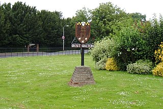
Bolton and Undercliffe is an electoral ward in the City of Bradford Metropolitan District Council, England. The population of the ward at the 2011 Census was 16,365. Bolton and Undercliffe covers the area east of Bradford Beck, between Shipley & Wrose to the north and central Bradford to the south. It is a largely urban area.

Fenny Compton is a village and parish in Warwickshire, England, about eight miles north of Banbury. In the 2001 census the parish had a population of 797, increasing to 808 at the 2011 census. Its name comes from the Anglo-Saxon Fennig Cumbtūn meaning "marshy farmstead in a valley".

Whittlesford is a village in Cambridgeshire, England, and also the name of an old hundred. The village is situated on the Granta branch of the River Cam, seven miles south of Cambridge. Whittlesford Parkway railway station serves the village.
Britwell Salome is a village and civil parish in South Oxfordshire, England centred 4+1⁄2 miles (7 km) northeast of Wallingford. The 2011 Census recorded the parish's population as 204.

Longworth is a village and civil parish in the Vale of White Horse, England. Historically within what was the north-west projection of Berkshire, boundary changes transferred it to Oxfordshire in 1974. The village is between Faringdon, 7 miles (11 km) to the west, and Oxford, 9 miles (14 km) to the northeast. The 2021 Census recorded the parish's population as 543.

Doddiscombsleigh is a small settlement in Devon, England. It is 5 miles (8 km) southwest of the city of Exeter and one mile East of the River Teign and the Teign Valley. Along with a few other places in Devon, it is one of the longest place names in England with 16 letters.
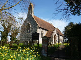
West Walton is a village and civil parish in the King's Lynn and West Norfolk District of Norfolk, England.

The Flask is a Grade II listed public house at 74–76 Highgate West Hill, Highgate, London. According to the 1936 Survey of London, a pub known as The Flask has stood on this spot since "at least as early as 1663". The present buildings probably date from the early 18th century, and were partially rebuilt in about 1767 by William Carpenter. A Manorial court met there in the eighteenth century. The Flask is currently owned and operated by the London-based Fuller's.

The Six Bells is a public house in St Michael's Street in St Albans, Hertfordshire, England. The seventeenth-century timber-framed building is situated within the walls of the Roman city of Verulamium.
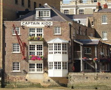
The Captain Kidd is a pub in Wapping, East London, that is named after the seventeenth century pirate William Kidd, who was executed at the nearby Execution Dock. The pub is a Grade II listed building, and was historically used as a coffee warehouse.

The Perseverance is a pub at 63 Lamb's Conduit Street, Bloomsbury, London WC1, on the corner with Great Ormond Street.

Carter Lane is a historic street in the City of London, running slightly south of Ludgate Hill and St. Paul's Cathedral. The modern Carter Lane is shown in three sections, named Shoe Makers Row, Great Carter Lane, and Little Carter Lane, on a London map of 1746.

The Bull is a pub on Main Road, St Paul's Cray, London Borough of Bromley.

The Old Bell is a pub at 95 Fleet Street, London EC4.

St Paul's Tavern is a former pub at 56 Chiswell Street, London EC1. It is now a restaurant, the Chiswell Street Dining Rooms.

