The Lecture Cutters

Last updated
The Lecture Cutters
The Lecture Cutters.jpg
North aspect centered, from Mt. Taylor
Highest point
Elevation 2,524 m (8,281 ft) [1]
Prominence 124 m (407 ft) [1]
Parent peak Mount Sir Richard [1]
Isolation 2.35 km (1.46 mi) [1]
Listing Mountains of British Columbia
Coordinates 49°58′52″N122°43′02″W / 49.98111°N 122.71722°W / 49.98111; -122.71722 [2]
Geography
Canada British Columbia relief location map.jpg
Red triangle with thick white border.svg
The Lecture Cutters
Location in British Columbia
Canada relief map 2.svg
Red triangle with thick white border.svg
The Lecture Cutters
The Lecture Cutters (Canada)
Location British Columbia, Canada
District New Westminster Land District
Protected area Garibaldi Provincial Park
Parent range Coast Mountains
McBride Range [3]
Topo map NTS 92G15 Mamquam Mountain
Climbing
First ascent 1971 John Clarke [4]

The Lecture Cutters are 2,524-metre (8,281-foot) mountain peaks in British Columbia, Canada.

Contents

Description

The Lecture Cutters is located in the McBride Range of the Coast Mountains, and 23 kilometres (14 mi) southeast of Whistler in Garibaldi Provincial Park. It is the third-highest point of the McBride Range. [1] Precipitation runoff and glacial meltwater from this mountain's slopes drains into the Cheakamus River. The Lecture Cutters is more notable for its steep rise above local terrain than for its absolute elevation as topographic relief is significant with the summit rising over 1,200 metres (3,937 ft) above the river in three kilometres (1.9 mi).

Etymology

The mountain's toponym was officially adopted August 27, 1965, by the Geographical Names Board of Canada as proposed by Dr. Roy Hooley (1924–1996), Alpine Club of Canada and professor of civil engineering at the University of British Columbia. [5] He was accustomed to students skipping his classes, especially members of UBC's Varsity Outdoors Club who regularly climbed in the Garibaldi Park area. [6]

Climate

Based on the Köppen climate classification, The Lecture Cutters is located in the marine west coast climate zone of western North America. [7] Most weather fronts originate in the Pacific Ocean, and travel east toward the Coast Mountains where they are forced upward by the range (orographic lift), causing them to drop their moisture in the form of rain or snowfall. As a result, the Coast Mountains experience high precipitation, especially during the winter months in the form of snowfall. Winter temperatures can drop below −20 °C with wind chill factors below −30 °C. This climate supports the McBride Glacier on the east slope. The months of July and August offer the most favorable weather for climbing The Lecture Cutters.

See also

Related Research Articles

<span class="mw-page-title-main">Wedge Mountain</span> Mountain in British Columbia, Canada

Wedge Mountain, 2,895 m (9,498 ft) prominence: 2,249 m (7,379 ft), often locally referred to as The Wedge or simply "Wedge", is the highest summit in the Garibaldi Ranges and therefore also Garibaldi Provincial Park, and is among the nearest of the many peaks visible from the Whistler Blackcomb Ski Area, lying north across the valley of Billygoat Pass from the Spearhead Range, which includes one of that resort's two flagship mountains, Blackcomb. It was named for its distinctive wedge shape by the Garibaldi Park Board in 1932 in preference to Mount Vancouver, which had been submitted earlier. It is part of an unnamed range forming the most northerly group of peaks in the Garibaldi Ranges, the other two most notable being Mount Weart, known as the Armchair because of its shape, and Mount Currie, which overlooks the First Nations Reserve of the same name and the neighbouring town of Pemberton. Wedge's very high prominence is defined by the divide between the Green and Cheakamus Rivers at a locality at the south end of Alta Lake known as Tokum Corners.

<span class="mw-page-title-main">The Spearhead</span> Peak in the Garibaldi Ranges of British Columbia, Canada

The Spearhead is a 2,457 m (8,061 ft) peak in the Garibaldi Ranges of British Columbia, Canada, and is one of the main summits of the Blackcomb Mountain portion of the Whistler Blackcomb ski resort, located at the apex of the Blackcomb and Spearhead Glaciers, which is named for it. It also is the namesake of the Spearhead Range, which is the short range flanking the north side of Fitzsimmons Creek and ending on its northwest end at Blackcomb Mountain. The mountain's name was officially adopted on August 27, 1965, by the Geographical Names Board of Canada.

<span class="mw-page-title-main">Overlord Mountain</span> Mountain in the country of Canada

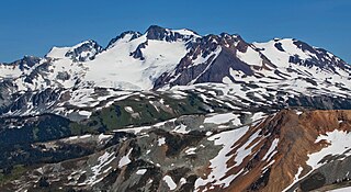
Overlord Mountain is a 2,625-metre (8,612-foot) glacier-clad peak located in the Garibaldi Ranges of the Coast Mountains, in Garibaldi Provincial Park of southwestern British Columbia, Canada. It is the highest point of the Fitzsimmons Range, which is a subset of the Garibaldi Ranges, and can be readily seen from the Whistler Blackcomb ski area. It is situated 15 km (9 mi) southeast of Whistler, and its nearest higher peak is Mount Macbeth, 3 km (2 mi) to the north-northeast. The Benvolio Glacier rests below the south aspect of the summit, the Fitzsimmons Glacier on the east aspect, and the expansive Overlord Glacier spans the northern and western aspects of the mountain. Precipitation runoff from the peak and meltwater from its glaciers drains into tributaries of the Cheakamus River. The first ascent of the mountain was made in 1923 by Phyllis Munday and Don Munday via the Benvolio Glacier. The mountain's descriptive name was recommended by the Garibaldi Park Board and officially adopted on September 2, 1930, by the Geographical Names Board of Canada.

<span class="mw-page-title-main">Mount Macbeth</span> Mountain in British Columbia, Canada

Mount Macbeth is a 2,639-metre (8,658-foot) glacier-clad peak located in the Garibaldi Ranges of the Coast Mountains, in Garibaldi Provincial Park of southwestern British Columbia, Canada. It is part of the Spearhead Range, which is a subset of the Garibaldi Ranges. It is situated 14 km (9 mi) southeast of Whistler, and 2 km (1 mi) south of Tremor Mountain, which is the highest point in the Spearhead Range. The Naden Glacier spreads out below the eastern aspect of the summit, the Macbeth Glacier lies below the south aspect, and the Curtain Glacier descends the northern slope. Precipitation runoff from the peak and meltwater from its glaciers drains into Fitzsimmons Creek which is a tributary of the Cheakamus River. Macbeth is most often climbed as part of the Spearhead Traverse. The first ascent of the mountain was made in 1969 by P. Starr, E. Bass, B. Ellis, and P. Macec via the northeast ridge. The peak was named in 1964 by an Alpine Club of Canada climbing party, to commemorate the 400th anniversary of William Shakespeare's birth. The mountain's name was officially adopted on August 27, 1965, by the Geographical Names Board of Canada.

<span class="mw-page-title-main">Mount Benvolio</span> Mountain in the country of Canada

Mount Benvolio is a 2,613-metre (8,573-foot) glacier-clad peak located in the Garibaldi Ranges of the Coast Mountains, in Garibaldi Provincial Park of southwestern British Columbia, Canada. It is the second-highest point of the Fitzsimmons Range, which is a subset of the Garibaldi Ranges. It is situated 15 km (9 mi) southeast of Whistler, and its nearest higher peak is Overlord Mountain, 0.7 km (0 mi) to the northwest. The Benvolio Glacier is set on the western slope of the peak, the Diavolo Glacier spreads out below the eastern aspect of the summit, and the Fitzsimmons Glacier descends the north slope. Precipitation runoff from the peak and meltwater from its glaciers drains into tributaries of the Cheakamus River.

<span class="mw-page-title-main">Tremor Mountain</span> Mountain in the country of Canada

Tremor Mountain is a prominent 2,691-metre (8,829-foot) summit located in the Garibaldi Ranges of the Coast Mountains, in Garibaldi Provincial Park of southwestern British Columbia, Canada. It is the highest point of the Spearhead Range, which is a subset of the Garibaldi Ranges. It is situated 13 km (8 mi) southeast of Whistler, and 8.7 km (5 mi) south of Wedge Mountain, its nearest higher peak. Precipitation runoff from the south side of the peak as well as meltwater from the Platform Glacier drains into Fitzsimmons Creek which is a tributary of the Green River. Meltwater from the Tremor Glacier on the northwestern slope drains to Wedge Creek, and meltwater from the Shudder Glacier on the northeast slope drains into Billygoat Creek, a tributary of the Lillooet River. Tremor Mountain is often climbed as part of the Spearhead Traverse. The first ascent of the mountain was made in 1928 by A.J. Campbell Garibaldi survey party. The mountain's name origin refers to unexplained earth tremors when the first ascent party was on the summit. The mountain's toponym was officially adopted on September 6, 1951, by the Geographical Names Board of Canada.

<span class="mw-page-title-main">Mount Cook (British Columbia)</span> Mountain in the country of Canada

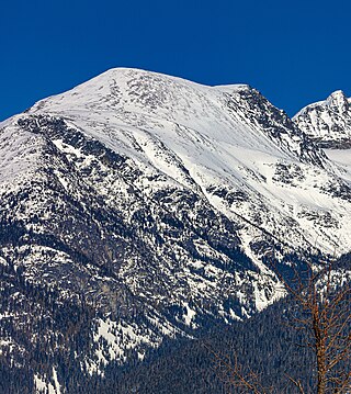
Mount Cook is a 2,676-metre (8,780-foot) mountain located in the Garibaldi Ranges of the Coast Mountains, in northwestern Garibaldi Provincial Park of southwestern British Columbia, Canada. It is situated above the north shore of Wedgemount Lake, 13 km (8 mi) northeast of Whistler, and its nearest higher peak is Mount Weart, 1.2 km (1 mi) to the southeast. The Armchair Glacier is set between Cook and Weart, and the Weart Glacier rests on the northern slope of Cook. Precipitation runoff from the peak and meltwater from the glaciers drains into Wedgemount Lake and Green River.

<span class="mw-page-title-main">Mount Ronayne</span> Mountain in the country of Canada

Mount Ronayne is a 2,290-metre (7,513-foot) summit located in the Pemberton Valley of British Columbia, Canada.

<span class="mw-page-title-main">Phyllis's Engine</span> Mountain in the country of Canada

Phyllis's Engine is a 2,517-metre (8,258-foot) granite pinnacle located in British Columbia, Canada.

<span class="mw-page-title-main">Whirlwind Peak</span>

Whirlwind Peak is a 2,427-metre (7,963-foot) mountain summit in southwestern British Columbia, Canada.

<span class="mw-page-title-main">Deception Peak</span> Mountain in the country of Canada

Deception Peak is a 2,233-metre (7,326-foot) summit in British Columbia, Canada.

<span class="mw-page-title-main">Cloudraker Mountain</span>

Cloudraker Mountain is a 2,385-metre (7,825-foot) glaciated summit in British Columbia, Canada.

<span class="mw-page-title-main">Mount Sir Richard</span>

Mount Sir Richard is a 2,681-metre (8,796-foot) glaciated summit in British Columbia, Canada.

<span class="mw-page-title-main">In-SHUCK-ch Mountain</span>

In-SHUCK-ch Mountain is a 2,386-metre (7,828-foot) summit in British Columbia, Canada.

<span class="mw-page-title-main">Outlier Peak</span>

Outlier Peak is a 2,422-metre (7,946-foot) mountain summit in British Columbia, Canada.

<span class="mw-page-title-main">Nivalis Mountain</span>

Nivalis Mountain is a 2,659-metre (8,724-foot) mountain summit in British Columbia, Canada.

<span class="mw-page-title-main">Mount Neal</span>

Mount Neal is a 2,552-metre (8,373-foot) glaciated summit in British Columbia, Canada.

<span class="mw-page-title-main">Carcajou Peak</span>

Carcajou Peak is a 2,239-metre (7,346-foot) mountain summit in British Columbia, Canada.

<span class="mw-page-title-main">Mount Moe</span>

Mount Moe is a 2,664-metre (8,740-foot) glaciated summit in British Columbia, Canada.

<span class="mw-page-title-main">Shudder Mountain</span>

Shudder Mountain is a 2,671-metre (8,763-foot) summit in British Columbia, Canada.

References

  1. 1 2 3 4 5 "The Lecture Cutters, British Columbia". Peakbagger.com. Retrieved 2024-03-05.
  2. "The Lecture Cutters". Geographical Names Data Base . Natural Resources Canada . Retrieved 2024-03-05.
  3. "The Lecture Cutters, Peakvisor.com" . Retrieved 2024-03-05.
  4. Climbers You Should Know About: John Clarke, Gripped, January 26, 2021. Retrieved 2024-03-05.
  5. "The Lecture Cutters". BC Geographical Names .
  6. G. P. V. Akrigg, Helen B. Akrigg, British Columbia Place Names, 1997, UBC Press, ISBN   9780774806374, p. 151.
  7. Peel, M. C.; Finlayson, B. L.; McMahon, T. A. (2007). "Updated world map of the Köppen−Geiger climate classification". Hydrol. Earth Syst. Sci. 11 (5): 1633. Bibcode:2007HESS...11.1633P. doi: 10.5194/hess-11-1633-2007 . ISSN   1027-5606.