Carcajou Peak

Last updated
Carcajou Peak
Carcajou Peak.jpg
Northeast aspect, from Mt. Taylor
Highest point
Elevation 2,239 m (7,346 ft) [1] [2]
Prominence 211 m (692 ft) [2]
Parent peak Nannygoat Peak [2]
Isolation 1.45 km (0.90 mi) [1]
Listing Mountains of British Columbia
Coordinates 50°01′21″N122°42′02″W / 50.02250°N 122.70056°W / 50.02250; -122.70056 [3]
Naming
Etymology Carcajou
Geography
Canada British Columbia relief location map.jpg
Red triangle with thick white border.svg
Carcajou Peak
Location in British Columbia
Canada relief map 2.svg
Red triangle with thick white border.svg
Carcajou Peak
Carcajou Peak (Canada)
Location British Columbia, Canada
District New Westminster Land District
Protected area Garibaldi Provincial Park
Parent range Coast Mountains
McBride Range [2]
Topo map NTS 92J2 Whistler
Climbing
First ascent 1971 John Clarke [4]

Carcajou Peak is a 2,239-metre (7,346-foot) mountain summit in British Columbia, Canada.

Contents

Description

Carcajou Peak is located 23 kilometres (14 mi) southeast of Whistler in Garibaldi Provincial Park. It is part of the McBride Range which is a subrange of the Coast Mountains. [1] Precipitation runoff from this mountain's south slope drains into headwaters of the Cheakamus River, whereas the north slope drains to the Lillooet River via Billygoat Creek. Carcajou Peak is more notable for its steep rise above local terrain than for its absolute elevation as topographic relief is significant with the summit rising 780 metres (2,560 ft) above the Cheakamus River in 1.5 kilometres (0.93 mi) and 1,580 metres (5,184 ft) above Billygoat Creek in four kilometres (2.5 mi).

History

The first ascent of the summit was made in 1971 by John Clarke. [4] The peak was named by John Clarke and in French-speaking parts of Canada, the wolverine is referred to as carcajou. The mountain's toponym was officially adopted on November 28, 1980, by the Geographical Names Board of Canada as submitted in 1978 by Karl Ricker of the Alpine Club of Canada. [5]

Climate

Based on the Köppen climate classification, Carcajou Peak is located in the marine west coast climate zone of western North America. [6] Most weather fronts originate in the Pacific Ocean, and travel east toward the Coast Mountains where they are forced upward by the range (orographic lift), causing them to drop their moisture in the form of rain or snowfall. As a result, the Coast Mountains experience high precipitation, especially during the winter months in the form of snowfall. Winter temperatures can drop below −20 °C with wind chill factors below −30 °C. The months of July and August offer the most favorable weather for climbing Carcajou Peak.

See also

Related Research Articles

<span class="mw-page-title-main">Wedge Mountain</span> Mountain in British Columbia, Canada

Wedge Mountain, 2,895 m (9,498 ft) prominence: 2,249 m (7,379 ft), often locally referred to as The Wedge or simply "Wedge", is the highest summit in the Garibaldi Ranges and therefore also Garibaldi Provincial Park, and is among the nearest of the many peaks visible from the Whistler Blackcomb Ski Area, lying north across the valley of Billygoat Pass from the Spearhead Range, which includes one of that resort's two flagship mountains, Blackcomb. It was named for its distinctive wedge shape by the Garibaldi Park Board in 1932 in preference to Mount Vancouver, which had been submitted earlier. It is part of an unnamed range forming the most northerly group of peaks in the Garibaldi Ranges, the other two most notable being Mount Weart, known as the Armchair because of its shape, and Mount Currie, which overlooks the First Nations Reserve of the same name and the neighbouring town of Pemberton. Wedge's very high prominence is defined by the divide between the Green and Cheakamus Rivers at a locality at the south end of Alta Lake known as Tokum Corners.

<span class="mw-page-title-main">Tremor Mountain</span> Mountain in the country of Canada

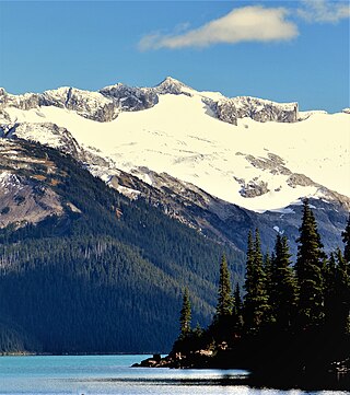
Tremor Mountain is a prominent 2,691-metre (8,829-foot) summit located in the Garibaldi Ranges of the Coast Mountains, in Garibaldi Provincial Park of southwestern British Columbia, Canada. It is the highest point of the Spearhead Range, which is a subset of the Garibaldi Ranges. It is situated 13 km (8 mi) southeast of Whistler, and 8.7 km (5 mi) south of Wedge Mountain, its nearest higher peak. Precipitation runoff from the south side of the peak as well as meltwater from the Platform Glacier drains into Fitzsimmons Creek which is a tributary of the Green River. Meltwater from the Tremor Glacier on the northwestern slope drains to Wedge Creek, and meltwater from the Shudder Glacier on the northeast slope drains into Billygoat Creek, a tributary of the Lillooet River. Tremor Mountain is often climbed as part of the Spearhead Traverse. The first ascent of the mountain was made in 1928 by A.J. Campbell Garibaldi survey party. The mountain's name origin refers to unexplained earth tremors when the first ascent party was on the summit. The mountain's toponym was officially adopted on September 6, 1951, by the Geographical Names Board of Canada.

<span class="mw-page-title-main">Mount Carr</span> Mountain in the country of Canada

Mount Carr is a 2,590-metre (8,497-foot) mountain summit located in British Columbia, Canada.

<span class="mw-page-title-main">Corrie Peak</span> Mountain in British Columbia, Canada

Corrie Peak is a 2,263-metre (7,425-foot) summit in British Columbia, Canada.

<span class="mw-page-title-main">Rhododendron Mountain</span> Mountain in British Columbia, Canada

Rhododendron Mountain is a 2,523-metre (8,278-foot) glaciated summit in British Columbia, Canada.

<span class="mw-page-title-main">Cloudraker Mountain</span> Mountain in British Columbia, Canada

Cloudraker Mountain is a 2,385-metre (7,825-foot) glaciated summit in British Columbia, Canada.

Whitecap Mountain is a 2,918-metre (9,573-foot) summit in British Columbia, Canada.

<span class="mw-page-title-main">Mount Sir Richard</span> Mountain in British Columbia, Canada

Mount Sir Richard is a 2,681-metre (8,796-foot) glaciated summit in British Columbia, Canada.

<span class="mw-page-title-main">In-SHUCK-ch Mountain</span> Mountain in British Columbia, Canada

In-SHUCK-ch Mountain is a 2,386-metre (7,828-foot) summit in British Columbia, Canada.

<span class="mw-page-title-main">The Lecture Cutters</span> Mountains in British Columbia, Canada

The Lecture Cutters are 2,524-metre (8,281-foot) mountain peaks in British Columbia, Canada.

<span class="mw-page-title-main">Outlier Peak</span> Mountain in British Columbia, Canada

Outlier Peak is a 2,422-metre (7,946-foot) mountain summit in British Columbia, Canada.

<span class="mw-page-title-main">Nivalis Mountain</span> Mountain in British Columbia, Canada

Nivalis Mountain is a 2,659-metre (8,724-foot) mountain summit in British Columbia, Canada.

<span class="mw-page-title-main">Mount Neal</span> Mountain in British Columbia, Canada

Mount Neal is a 2,552-metre (8,373-foot) glaciated summit in British Columbia, Canada.

<span class="mw-page-title-main">Mount Moe</span> Mountain in British Columbia, Canada

Mount Moe is a 2,664-metre (8,740-foot) glaciated summit in British Columbia, Canada.

<span class="mw-page-title-main">Twin Goat Mountain</span> Mountain in British Columbia, Canada

Twin Goat Mountain is a 2,128-metre (6,982-foot) summit in British Columbia, Canada.

<span class="mw-page-title-main">Shudder Mountain</span> Mountain in British Columbia, Canada

Shudder Mountain is a 2,671-metre (8,763-foot) summit in British Columbia, Canada.

<span class="mw-page-title-main">Icecap Peak</span> Mountain in British Columbia, Canada

Icecap Peak is a 2,435-metre (7,989-foot) glaciated summit in British Columbia, Canada.

<span class="mw-page-title-main">Amicus Mountain</span> Mountain in British Columbia, Canada

Amicus Mountain is a 2,510-metre (8,235-foot) glaciated summit in British Columbia, Canada.

<span class="mw-page-title-main">Mount Evans (British Columbia)</span> Mountain in British Columbia, Canada

Mount Evans is a 2,250-metre (7,382-foot) glaciated summit in British Columbia, Canada.

<span class="mw-page-title-main">Tzoonie Mountain</span> Mountain in British Columbia, Canada

Tzoonie Mountain is a 2,123-metre (6,965-foot) summit in British Columbia, Canada.

References

  1. 1 2 3 "Carcajou Peak, British Columbia". Peakbagger.com. Retrieved 2024-03-07.
  2. 1 2 3 4 "Carcajou Peak, Peakvisor.com" . Retrieved 2024-03-07.
  3. "Carcajou Peak". Geographical Names Data Base . Natural Resources Canada . Retrieved 2024-03-07.
  4. 1 2 Climbers You Should Know About: John Clarke, Gripped, January 26, 2021. Retrieved 2024-03-07.
  5. "Carcajou Peak". BC Geographical Names .
  6. Peel, M. C.; Finlayson, B. L.; McMahon, T. A. (2007). "Updated world map of the Köppen−Geiger climate classification". Hydrol. Earth Syst. Sci. 11 (5): 1633. Bibcode:2007HESS...11.1633P. doi: 10.5194/hess-11-1633-2007 . ISSN   1027-5606.