Mount Sir Richard

Last updated
Mount Sir Richard
Mount Sir Richard.jpg
North aspect centered at top, from Mt. Taylor
Highest point
Elevation 2,681 m (8,796 ft) [1] [2]
Prominence 886 m (2,907 ft) [3]
Parent peak Tremor Mountain [1]
Isolation 12.51 km (7.77 mi) [3]
Listing Mountains of British Columbia
Coordinates 49°57′50″N122°42′04″W / 49.96389°N 122.70111°W / 49.96389; -122.70111 [4]
Naming
Etymology Sir Richard McBride
Geography
Canada British Columbia relief location map.jpg
Red triangle with thick white border.svg
Mount Sir Richard
Location in British Columbia
Canada relief map 2.svg
Red triangle with thick white border.svg
Mount Sir Richard
Mount Sir Richard (Canada)
Location British Columbia, Canada
District New Westminster Land District [5]
Protected area Garibaldi Provincial Park
Parent range Coast Mountains
McBride Range [3]
Topo map NTS 92G15 Mamquam Mountain
Climbing
First ascent 1937

Mount Sir Richard is a 2,681-metre (8,796-foot) glaciated summit in British Columbia, Canada.

Contents

Description

Mount Sir Richard is located in the McBride Range of the Coast Mountains, and 25 kilometres (16 mi) southeast of Whistler in Garibaldi Provincial Park. It is the highest point of the McBride Range and seventh-highest peak within the park. [3] [1] Precipitation runoff and glacial meltwater from this mountain's south and east slopes drains to the Lillooet River via Tuwasus Creek, whereas the north and west slopes drain into headwaters of the Cheakamus River. Mount Sir Richard is more notable for its steep rise above local terrain than for its absolute elevation as topographic relief is significant with the summit rising 1,880 metres (6,168 ft) above Tuwasus Creek in less than six kilometres (3.7 mi) and 1,380 metres (4,527 ft) above Cheakamus River in five kilometres (3.1 mi).

History

Richard McBride Richard McBride.jpg
Richard McBride

The mountain's name honors Sir Richard McBride (1870–1917). [4] The toponym was officially adopted September 2, 1930, by the Geographical Names Board of Canada. [5] In 1903, at the age of 33, he became the youngest premier in the history of British Columbia. McBride was knighted in 1912, then resigned as premier in 1915 and became British Columbia's agent-general in London. There is also Mount McBride located on Vancouver Island that is named after him.

The first ascent of the summit was made on May 2, 1937, by Don Munday, Phyllis Munday, and Pip Brock via the Cheakamus River Valley and McBride Glacier. [2] Their adventure took 14 days. [6]

Climate

Based on the Köppen climate classification, Mount Sir Richard is located in the marine west coast climate zone of western North America. [7] Most weather fronts originate in the Pacific Ocean, and travel east toward the Coast Mountains where they are forced upward by the range (orographic lift), causing them to drop their moisture in the form of rain or snowfall. As a result, the Coast Mountains experience high precipitation, especially during the winter months in the form of snowfall. Winter temperatures can drop below −20 °C with wind chill factors below −30 °C. This climate supports the Ubyssey Glacier on the south and west slopes of the peak, as well as the McBride Glacier on the north and east slopes. The months of July and August offer the most favorable weather for climbing Mount Sir Richard.

See also

Related Research Articles

<span class="mw-page-title-main">Mount Munday</span>

Mount Munday is one of the principal summits of the Pacific Ranges of the Coast Mountains in British Columbia, Canada. It is 3,356 m (11,010 ft) in elevation and stands in the Waddington Range six kilometres southeast of Mount Waddington 4,019 m (13,186 ft), which is the highest summit in the Coast Mountains.

<span class="mw-page-title-main">Overlord Mountain</span> Mountain in the country of Canada

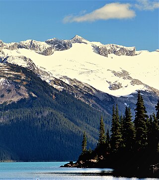
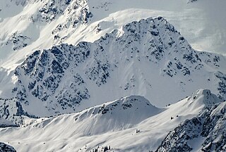
Overlord Mountain is a 2,625-metre (8,612-foot) glacier-clad peak located in the Garibaldi Ranges of the Coast Mountains, in Garibaldi Provincial Park of southwestern British Columbia, Canada. It is the highest point of the Fitzsimmons Range, which is a subset of the Garibaldi Ranges, and can be readily seen from the Whistler Blackcomb ski area. It is situated 15 km (9 mi) southeast of Whistler, and its nearest higher peak is Mount Macbeth, 3 km (2 mi) to the north-northeast. The Benvolio Glacier rests below the south aspect of the summit, the Fitzsimmons Glacier on the east aspect, and the expansive Overlord Glacier spans the northern and western aspects of the mountain. Precipitation runoff from the peak and meltwater from its glaciers drains into tributaries of the Cheakamus River. The first ascent of the mountain was made in 1923 by Phyllis Munday and Don Munday via the Benvolio Glacier. The mountain's descriptive name was recommended by the Garibaldi Park Board and officially adopted on September 2, 1930, by the Geographical Names Board of Canada.

<span class="mw-page-title-main">Mount Benvolio</span> Mountain in the country of Canada

Mount Benvolio is a 2,613-metre (8,573-foot) glacier-clad peak located in the Garibaldi Ranges of the Coast Mountains, in Garibaldi Provincial Park of southwestern British Columbia, Canada. It is the second-highest point of the Fitzsimmons Range, which is a subset of the Garibaldi Ranges. It is situated 15 km (9 mi) southeast of Whistler, and its nearest higher peak is Overlord Mountain, 0.7 km (0 mi) to the northwest. The Benvolio Glacier is set on the western slope of the peak, the Diavolo Glacier spreads out below the eastern aspect of the summit, and the Fitzsimmons Glacier descends the north slope. Precipitation runoff from the peak and meltwater from its glaciers drains into tributaries of the Cheakamus River.

<span class="mw-page-title-main">Grenelle Mountain</span> Mountain summit in British Columbia, Canada

Grenelle Mountain is a 3,047-metre (9,997-foot) mountain summit located in British Columbia, Canada.

<span class="mw-page-title-main">Stupendous Mountain</span> Mountain in the country of Canada

Stupendous Mountain is a 2,682-metre (8,799-foot) mountain summit located in British Columbia, Canada.

<span class="mw-page-title-main">Mount Carr</span> Mountain in the country of Canada

Mount Carr is a 2,590-metre (8,497-foot) mountain summit located in British Columbia, Canada.

<span class="mw-page-title-main">Isosceles Peak</span> Mountain in the country of Canada

Isosceles Peak is a 2,488-metre (8,163-foot) mountain summit located in British Columbia, Canada.

<span class="mw-page-title-main">Phyllis's Engine</span> Mountain in the country of Canada

Phyllis's Engine is a 2,517-metre (8,258-foot) granite pinnacle located in British Columbia, Canada.

<span class="mw-page-title-main">Parapet Peak (Garibaldi Provincial Park)</span> Mountain in the country of Canada

Parapet Peak is a 2,463-metre (8,081-foot) mountain summit located in British Columbia, Canada.

<span class="mw-page-title-main">Jubilee Mountain</span> Mountain in British Columbia, Canada

Jubilee Mountain is a 2,751-metre (9,026-foot) mountain summit in British Columbia, Canada.

<span class="mw-page-title-main">In-SHUCK-ch Mountain</span> Mountain in British Columbia, Canada

In-SHUCK-ch Mountain is a 2,386-metre (7,828-foot) summit in British Columbia, Canada.

<span class="mw-page-title-main">The Lecture Cutters</span> Mountains in British Columbia, Canada

The Lecture Cutters are 2,524-metre (8,281-foot) mountain peaks in British Columbia, Canada.

<span class="mw-page-title-main">Outlier Peak</span> Mountain in British Columbia, Canada

Outlier Peak is a 2,422-metre (7,946-foot) mountain summit in British Columbia, Canada.

<span class="mw-page-title-main">Nivalis Mountain</span> Mountain in British Columbia, Canada

Nivalis Mountain is a 2,659-metre (8,724-foot) mountain summit in British Columbia, Canada.

<span class="mw-page-title-main">Mount Neal</span> Mountain in British Columbia, Canada

Mount Neal is a 2,552-metre (8,373-foot) glaciated summit in British Columbia, Canada.

<span class="mw-page-title-main">Carcajou Peak</span> Mountain in British Columbia, Canada

Carcajou Peak is a 2,239-metre (7,346-foot) mountain summit in British Columbia, Canada.

<span class="mw-page-title-main">Mount Moe</span> Mountain in British Columbia, Canada

Mount Moe is a 2,664-metre (8,740-foot) glaciated summit in British Columbia, Canada.

<span class="mw-page-title-main">Mount Evans (British Columbia)</span> Mountain in British Columbia, Canada

Mount Evans is a 2,250-metre (7,382-foot) glaciated summit in British Columbia, Canada.

<span class="mw-page-title-main">Combatant Mountain</span> Mountain in British Columbia, Canada

Combatant Mountain, also called Mount Combatant, is a 3,762-metre (12,343-foot) summit in British Columbia, Canada.

<span class="mw-page-title-main">Mount Pitt</span> Summit in British Columbia, Canada

Mount Pitt is a 2,487-metre (8,159-foot) summit in British Columbia, Canada.

References

  1. 1 2 3 "Mount Sir Richard, Peakvisor.com" . Retrieved 2024-03-04.
  2. 1 2 Kathryn Bridge, A Passion for Mountains: The Lives of Don and Phyllis Munday, 2006, Rocky Mountain Books Ltd, ISBN   9781894765695, p. 199–201, 227.
  3. 1 2 3 4 "Mount Sir Richard, British Columbia". Peakbagger.com. Retrieved 2024-03-04.
  4. 1 2 "Mount Sir Richard". BC Geographical Names .
  5. 1 2 "Mount Sir Richard". Geographical Names Data Base . Natural Resources Canada . Retrieved 2024-03-04.
  6. Whistlermuseum.org, Tag: Mount Sir Richard, Pip Brock part 2, July 30, 2011.
  7. Peel, M. C.; Finlayson, B. L.; McMahon, T. A. (2007). "Updated world map of the Köppen−Geiger climate classification". Hydrol. Earth Syst. Sci. 11 (5): 1633. Bibcode:2007HESS...11.1633P. doi: 10.5194/hess-11-1633-2007 . ISSN   1027-5606.