
Coconino County is a county located in the north central part of the U.S. state of Arizona. The population was 134,421 at the 2010 census. The county seat is Flagstaff. The county takes its name from Cohonino, a name applied to the Havasupai. It is the second-largest county by area in the contiguous United States, behind San Bernardino County, California, with its 18,661 square miles (48,300 km2), or 16.4% of Arizona's total area, making it larger than each of the nine smallest states.

Yavapai County is near the center of the U.S. state of Arizona. As of the 2010 census, its population was 211,073. The county seat is Prescott.
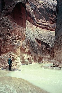
The Paria River is a tributary of the Colorado River, approximately 95 miles (153 km) long, in southern Utah and northern Arizona in the United States. It drains a rugged and arid region northwest of the Colorado, flowing through roadless slot canyons along part of its course.

Valle is a census-designated place in Coconino County, Arizona, United States. As of the 2010 US Census the population of Valle was 832. It lies at an altitude of 5,994 feet (1,827 m), at the junction of U.S. Route 180 and State Route 64. Its attractions include the Valle Airport (40G), the Planes of Fame Air Museum, and Flintstones Bedrock City amusement park. Drivers often stop at the town on their way to the Grand Canyon from either Williams or Flagstaff, as it is approximately at the halfway point.
Coconino Sandstone is a geologic formation named after its exposure in Coconino County, Arizona. This formation spreads across the Colorado Plateau province of the United States, including northern Arizona, northwest Colorado, Nevada, and Utah.
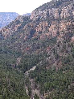
Oak Creek Canyon is a river gorge located in northern Arizona between the cities of Flagstaff and Sedona. The canyon is often described as a smaller cousin of the Grand Canyon because of its scenic beauty. State Route 89A enters the canyon on its north end via a series of hairpin turns before traversing the bottom of the canyon for about 13 miles (21 km) until the highway enters the town of Sedona. The Oak Creek Canyon–Sedona area is second only to Grand Canyon as the most popular tourist destination in Arizona.

Sycamore Canyon is the second largest canyon in the Arizona redrock country, after Oak Creek Canyon. The 21-mile (34 km) long scenic canyon reaches a maximum width of about 7 miles (11 km). It is in North Central Arizona bordering and below the Mogollon Rim, and is located west and northwest of Sedona in Yavapai and Coconino counties.

Granite Mountain is a 7,628-foot (2,325 m) mountain located in Yavapai County, Arizona that covers roughly 12 square miles (31 km2). It was once known as Mount Gurley, for the first governor of the Arizona Territory, John A. Gurley. Its southwest face has a sheer granite cliff approximately 500 feet high that is one of the best locations for rock climbing in the state of Arizona. It is located in the Granite Mountain Wilderness, which is managed as a part of the Prescott National Forest. The mountain stands at the northern end of the Sierra Prietas, and borders Skull Valley on the west, on the northwest by the Santa Maria Mountains, and east by the Williamson Valley.

Red Rock is a populated place in Yavapai County, Arizona, United States. Red Rock is 4.5 miles (7.2 km) southwest of Sedona. In the late 19th century, Red Rock was the principal settlement in the Oak Creek Canyon area. Red Rock is now an upscale suburb of Sedona.

Marble Canyon is a populated place in Coconino County, Arizona, United States. Marble Canyon is located on U.S. Route 89A at the Navajo Bridge, 12 miles (19 km) southwest of Page. Marble Canyon has a post office with ZIP code 86036. Marble Canyon is near Lee's Ferry, the former location of a ferry established by John D. Lee, a Mormon settler. It is often used by people entering the Colorado River for fishing and rafting trips.
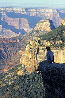
North Rim is a populated place in Coconino County, Arizona, United States. It is located adjacent to the Grand Canyon within Grand Canyon National Park.
House Mountain is a shield volcano located in the U.S. state of Arizona located between the Sedona Red Rock Country and the Verde Valley in the Coconino National Forest. House Mountain erupted approximately 13-15 million years ago on the edge of where the Mogollon Rim stood at that time. Thus, the basalt that was emitted preserved the sedimentary layers below it, including the Schnebly Hill Formation and the thin band of Fort Apache Limestone. The Mogollon Rim has receded at a rate of 1 foot per 600 years since and the current edge of the rim can be seen several miles away from the summit.
Excalibur is a formation on the north rim of the Grand Canyon in Coconino County, Arizona. It was named by cartographer and geologist François E. Matthes in 1908 for Excalibur, the legendary sword of King Arthur which was given to him by the Lady of the Lake. Other features in the area include the Holy Grail, Guinevere Castle, Elaine Castle, and Galahad Point whose names refer to the Arthurian legend. The name probably refers to a spire near the summit of the promontory which might resemble the handle of Excalibur.

Big Springs is an unincorporated community in Coconino County, Arizona, United States. Big Springs is located in Kaibab National Forest 10.8 miles (17.4 km) southwest of Jacob Lake.
Angell was a populated place in Coconino County, Arizona. It has an estimated elevation of 5,912 feet (1,802 m) above sea level.
Apex was a lumber town on the Grand Canyon Railway situated in Coconino County, Arizona.
Coconino station was a stop on the Grand Canyon Railway in Coconino County, Arizona. It was the penultimate stop before reaching Grand Canyon station. The concrete base of the original station and ruins of the section house remain. It has an estimated elevation of 6,368 feet (1,941 m) above sea level.
Dennison was a stop on the Atchison, Topeka and Santa Fe Railway between Canyon Diablo, Arizona, and Winslow, Arizona. Formerly in Yavapai County, it came to be in Coconino County upon the latter's creation in 1891. Dennison was named for a railroad roadmaster named Denny.
Frazier Wells, sometimes known as Frazier Well or Fraziers Well, is a populated place situated in Coconino County, Arizona, located about 30 miles northeast of Peach Springs, Arizona. It has an estimated elevation of 6,047 feet (1,843 m) above sea level.

Tapeats Creek is a creek located entirely within the Grand Canyon National Park. It flows southwest from its source near the North Rim of the canyon to the Colorado River at the base of the canyon. It was named by the Second Powell Expedition in the winter of 1871–1872 for a Southern Paiute Indian who claimed ownership of the stream. It contributes the largest amount of water to the Colorado of any tributary on the north side within the Grand Canyon.


