
U.S. Highway 63 is a north-south U.S. highway that begins in Ruston, LA. In the US state of Arkansas the highway enters the state from Louisiana concurrent with US 167 in Junction City. The highway runs north through the eastern part of the state, serving rural areas of South Arkansas and the Arkansas Delta, as well as Pine Bluff and Jonesboro. The highway exits the state at Mammoth Spring traveling into Missouri.

The South Main Street Commercial Historic District of Little Rock, Arkansas is a historic district encompassing a five-block stretch of South Main Street, just south of the city's downtown area. Developed between about 1905 and 1950, the section of South Main between 12th and 17th streets represents an architectural cross-section of the commercial development that took place in the city during that time. Early buildings, such as the 1905 Lincoln Building, were Classical Revival in style, while generational changes in style are exemplified by the presence of Craftsman and Art Deco buildings. One residential building, the First Hotze House, predates the area's commercial development, and stands as a reminder of its residential past.

U.S. Route 62 is a U.S. highway running from El Paso, Texas northeast to Niagara Falls, New York. In the U.S. state of Arkansas, the route runs 329.9 miles from the Oklahoma border near Summers east to the Missouri border in St. Francis, serving the northern portion of the state. The route passes through several cities and towns, including Fayetteville, Springdale, Bentonville, Harrison, Mountain Home, Pocahontas, and also Piggott. US 62 runs concurrent with several highways in Arkansas including Interstate 49 and U.S. Route 71 between Fayetteville and Bentonville, U.S. Route 412 through much of the state, U.S. Route 65 in the Harrison area, and with U.S. Route 63 and U.S. Route 67 in northeast Arkansas.
The University of Arkansas Campus Historic District is a historic district that was listed on the National Register of Historic Places on September 23, 2009. The district covers the historic core of the University of Arkansas campus, including 25 buildings.

The Tyronza Water Tower is a historic elevated steel water tower located in Tyronza, Arkansas. It was built in 1935 by the Chicago Bridge & Iron Company in conjunction with the Public Works Administration as part of a project to improve the local water supply. It was added to the National Register of Historic Places in 2007, as part of a multiple-property listing that included numerous other New Deal-era projects throughout Arkansas. The Tyronza Water Tower is considered an excellent representation of 1930s-era waterworks construction.
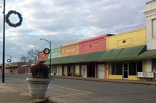
The Lake Village Commercial Historic District encompasses the historic commercial heart of Lake Village, Arkansas, the county seat of Chicot County in the Mississippi River delta region of southeastern Arkansas. The district covers about six square blocks of downtown Lake Village, bounded roughly by Jackson Street to the north, Lakeshore Drive to the east, Church Street to the south, and Chicot Street to the west. This area represents the growth of Lake Village during its period of greatest prosperity, between 1906 and 1960. The city's growth was spurred by the arrival of the railroad in 1903, and most of the district's buildings were built between 1900 and 1930. Most of the buildings are vernacular commercial buildings; the John Tushek Building at 202 Main Street is one interesting example of Beaux Arts styling, and 218–222 Main Street has some Italianate styling. The district includes the Lake Village Confederate Monument, which has been a local landmark since 1910.

The El Dorado Commercial Historic District encompasses the historic commercial heart of downtown El Dorado, Arkansas. The city serves as the seat of Union County, and experienced a significant boom in growth during the 1920s, after oil was discovered in the area. The business district that grew in this time is anchored by the Union County Courthouse, at the corner of Main and Washington Streets, where the Confederate memorial is also located. The historic district listed on the National Register of Historic Places in 2003 includes the city blocks surrounding the courthouse, as well as several blocks extending east along Main Street and south along Washington Street. Most of the commercial buildings are one and two stories in height and are built of brick. Notable exceptions include the Exchange Bank building, which was, at nine stories, the county's first skyscraper, and the eight-story Murphy Oil building. There are more than forty contributing properties in the district.

The Smackover Historic Commercial District encompasses the civic and commercial heart of the small town of Smackover, Arkansas. It consists of sixteen buildings lining a single block of Broadway north of 7th Avenue. The area is reflective of Smackover's explosive growth following the discovery of oil in 1925; most of the buildings were built between 1925 and 1940. They are mostly vernacular commercial buildings, one or two stories in height, with flat roofs obscured by a parapet on the main facade. Also included in the district are the Methodist Episcopal church, the old fire station, and the old city hall and jail. The district was listed on the National Register of Historic Places in 1990.

The Fordyce Commercial Historic District encompasses the historic heart of Fordyce, Arkansas, the county seat of Dallas County. It encompasses four city blocks of North Main Street, between 1st and 4th, and includes properties on these adjacent streets. Fordyce was founded in 1882, and the oldest building in the district, the Nutt-Trussell Building at 202 North Main Street, was built c. 1884. Spurred by the logging industry and the Cotton Belt Railroad, Fordyce's downtown area had 25 buildings by 1901, and continued to grow over the next few decades, resulting in a concentration of period commercial architecture in its downtown. The district was listed on the National Register of Historic Places in 2008.

The Nashville Commercial Historic District encompasses much of the historic downtown commercial area of Nashville, Arkansas, and the major commercial center in Howard County. It is centered at the junction of Main and Howard Streets, extending eastward along East Howard, and north and south along Main Street for about one block. Most of the buildings in the district are tall single-story brick structures, some covered in stucco. They were built between about 1895 and the 1930s, with a smaller number appearing later. The area's economic activity was driven first by the arrival of the railroad, which defined the layout of the town, and then by the growth of lumber and agriculture in the region. The oldest building in the district is 203 North Main, built c. 1895 with modest Romanesque Revival styling.

The Marianna Commercial Historic District encompasses the historic civic and commercial heart of Marianna, Arkansas, the county seat of Lee County. It comprises two blocks of Main Street and two blocks of Poplar Street, which cross at the northwest corner of Court Square, a city park where the Gen. Robert E. Lee Monument is found, and extends south to include a few buildings on Liberty Street.
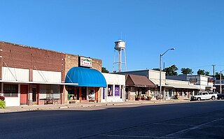
The McCrory Commercial Historic District encompasses the historic commercial center of the city of McCrory, Arkansas. This area is located along Edmonds Street, the city's main north–south thoroughfare. The district includes 26 historically significant buildings in a 2-1/2 block area north of the railroad tracks, including a few buildings facing adjacent streets. McCrory was founded in 1890, and much of its early commercial building stock was wood-frame. Beginning about 1900 use of brick and stone in construction grew, and after a major fire in 1909 most of the buildings were built in brick. The area achieved most of its present appearance by about 1930. Most of the buildings are a single story in height, with a few that are two.

The Batesville Commercial Historic District encompasses about four city blocks of the historic downtown of Batesville, Arkansas. This area's current appearance is largely the result of development between about 1880 and the 1940s, although it includes a portion of Arkansas' oldest platted Main Street, dating to 1821. When originally listed on the National Register of Historic Places in 1982, the district included 25 historic properties on two blocks of Main Street, on either side of Central Avenue, as well as a few properties on Central. In 1990 the size of the district was more than doubled, adding two more city blocks on Main Street and 36 buildings. Most of the buildings are brick and masonry commercial structures, two stories in height, with party walls joining them at the sides.

The Tyronza Methodist Episcopal Church, South is a historic church building at 129 Church Street in Tyronza, Arkansas. It is a single-story masonry structure, built out of orange brick laid on a raised basement. Its main facade, facing west, has a projecting vestibule with a shallow-pitch roofline matching that of the main roof, and is approached by a broad and shallow flight of stairs. Windows on this facade are narrow, with rounded-arch tops, while other windows on the building are either arched or rectangular sash. The church was built in 1928, and is a good local example of Classical Revival design. Its architect is unknown; its design resembles that of the Wabbaseka Methodist Episcopal Church, South.

The Pine Bluff Commercial Historic District encompasses a portion of the historic city center of Pine Bluff, Arkansas. It extends from Barraque Street south along Main Street, extending in places to properties alongside streets. The area's commercial development began about 1840, when the courthouse square was laid out at Barraque and Main, and proceeded through the early 20th century. Most of the commercial properties of the district were built between 1880 and 1910, and are reflective architecturally of late 19th-century commercial building styles.

The Main Street Commercial District is a historic district encompassing a typical downtown city block of Little Rock, Arkansas, during the first half of the 20th century. The district consists of ten buildings lining the east side of the 300 block of Main Street. This area was completely redeveloped after a fire in February 1900 sparked an explosion at an arms company, levelling the block. The buildings in the district are stylistically diverse, and were built between 1900 and 1955.

The Keo Commercial Historic District encompasses a cluster of commercial and industrial buildings that make up the economic center of the small city of Keo, Arkansas. The district includes a two-block section of Main Street, anchored at its southern end by the Cobb Cotton Gin complex, and on the north by Arkansas Highway 232, where it extends a short way in both directions. The community grew around the Cotten Belt Railroad line, which Main Street was laid out just west of. The cotton gin complex has its origins in 1906, as a means for local farmers to process their cotton and send it on to market via the railroad.

The Heber Springs Commercial Historic District encompasses the early commercial heart of Heber Springs, Arkansas. The district extends along Main Street, between Broadway and 6th Street, including several buildings along some of the cross streets. The area was developed beginning in 1881, and grew in the late 19th and early 20th centuries, featuring a diversity of commercial architecture from that period. Prominent buildings include the Cleburne County Courthouse (1914) and the Morton Building at 101 South 3rd Street, the city's oldest surviving commercial building (1895).

The Leslie Commercial Historic District encompasses a one-block historic area of downtown Leslie, Arkansas. The basically linear district runs on Main Street between Oak and Walnut Streets, and includes 18 buildings and a small city park. Most of the buildings were built in the early decades of the 20th century, and are one and two-story brick buildings.
