Unionville Center, Ohio

Last updated

Unionville Center, Ohio
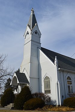
Unionville Center UMC.jpg
Methodist church
OHMap-doton-Unionville Center.png
Location of Unionville Center, Ohio
Map of Union County Ohio Highlighting Unionville Center Village.png
Location of Unionville Center in Union County
Coordinates: 40°08′12″N83°20′30″W / 40.13667°N 83.34167°W / 40.13667; -83.34167
Country United States
State Ohio
County Union
Township Darby
Area
[1]
  Total0.16 sq mi (0.42 km2)
  Land0.16 sq mi (0.41 km2)
  Water0.00 sq mi (0.01 km2)
Elevation
[2]
971 ft (296 m)
Population
 (2020)
  Total241
  Density1,525.32/sq mi (587.27/km2)
Time zone UTC-5 (Eastern (EST))
  Summer (DST) UTC-4 (EDT)
ZIP code
43077
Area code 614
FIPS code 39-78834 [3]
GNIS feature ID2400026 [2]

Unionville Center is a village in Union County, Ohio, in the United States. The population was 241 as of the 2020 census.

Contents

The village is home to the Charles W. Fairbanks Festival that is held each May. The village also has a post office with the ZIP Code of 43077. [4]

History

Unionville Center was originally called Unionville, and under the latter name was laid out and platted in 1847. [5] The Unionville Center post office has been in operation since 1848. [6] The village was incorporated in 1879. [5]

Geography

According to the United States Census Bureau, the village has a total area of 0.17 square miles (0.44 km2), of which 0.16 square miles (0.41 km2) is land and 0.01 square miles (0.03 km2) is water. [7]

Demographics

Historical population
CensusPop.Note
1880 200
1890 23115.5%
1900 25912.1%
1910 239−7.7%
1920 193−19.2%
1930 189−2.1%
1940 23323.3%
1950 2371.7%
1960 30528.7%
1970 255−16.4%
1980 2726.7%
1990 238−12.5%
2000 29925.6%
2010 233−22.1%
2020 2413.4%
U.S. Decennial Census [8]

The population of the village was 231 in 1890, 259 in 1900, and 239 in 1910. [9]

2010 census

As of the census [10] of 2010, there were 233 people, 78 households, and 56 families living in the village. The population density was 1,456.3 inhabitants per square mile (562.3/km2). There were 82 housing units at an average density of 512.5 per square mile (197.9/km2). The racial makeup of the village was 96.1% White, 0.4% Native American, 2.6% Asian, and 0.9% from two or more races. Hispanic or Latino of any race were 0.9% of the population.

There were 78 households, of which 42.3% had children under the age of 18 living with them, 53.8% were married couples living together, 12.8% had a female householder with no husband present, 5.1% had a male householder with no wife present, and 28.2% were non-families. 19.2% of all households were made up of individuals, and 9% had someone living alone who was 65 years of age or older. The average household size was 2.99 and the average family size was 3.38.

The median age in the village was 39.8 years. 29.6% of residents were under the age of 18; 6.4% were between the ages of 18 and 24; 23.7% were from 25 to 44; 28.4% were from 45 to 64; and 12% were 65 years of age or older. The gender makeup of the village was 51.5% male and 48.5% female.

2000 census

As of the census [3] of 2000, there were 299 people, 110 households, and 85 families living in the village. The population density was 1,874.5 inhabitants per square mile (723.7/km2). There were 121 housing units at an average density of 758.6 per square mile (292.9/km2). The racial makeup of the village was 99.67% White, and 0.33% from two or more races. Hispanic or Latino of any race were 1.34% of the population.

There were 110 households, out of which 33.6% had children under the age of 18 living with them, 66.4% were married couples living together, 3.6% had a female householder with no husband present, and 22.7% were non-families. 21.8% of all households were made up of individuals, and 9.1% had someone living alone who was 65 years of age or older. The average household size was 2.72 and the average family size was 3.18.

In the village, the population was spread out, with 26.8% under the age of 18, 4.7% from 18 to 24, 30.4% from 25 to 44, 22.7% from 45 to 64, and 15.4% who were 65 years of age or older. The median age was 39 years. For every 100 females there were 103.4 males. For every 100 females age 18 and over, there were 99.1 males.

The median income for a household in the village was $45,682, and the median income for a family was $52,750. Males had a median income of $32,500 versus $23,750 for females. The per capita income for the village was $16,591. About 2.7% of families and 6.3% of the population were below the poverty line, including 9.5% of those under the age of eighteen and none of those 65 or over.
Notable person

Charles W. Fairbanks, twenty-sixth Vice President of the United States

Related Research Articles

<span class="mw-page-title-main">Salcha, Alaska</span> Census-designated place in Alaska, United States

Salcha is a census-designated place (CDP) in Fairbanks North Star Borough in the U.S. state of Alaska. It is part of the Fairbanks, Alaska Metropolitan Statistical Area. The population was 1,095 at the 2010 census, up from 854 in 2000.

<span class="mw-page-title-main">Dot Lake, Alaska</span> CDP in Alaska, United States

Dot Lake is a census-designated place (CDP) in Southeast Fairbanks Census Area, Alaska, United States. It is located on the Alaska Highway between Delta Junction and Tok. The population was 13 at the 2010 census, down from 19 in 2000.

<span class="mw-page-title-main">Northway Village, Alaska</span> CDP in Alaska, United States

Northway Village was a census-designated place (CDP) in Southeast Fairbanks Census Area, Alaska, United States. It was merged with Northway CDP prior to the 2020 Census. The population was 98 at the 2010 census, down from 107 in 2000.

<span class="mw-page-title-main">Dongola, Illinois</span> Village in Illinois, United States

Dongola is a village in Union County, Illinois, United States. The population was 726 at the 2010 census.

<span class="mw-page-title-main">Unionville, Iowa</span> City in Iowa, United States

Unionville is a city in Appanoose County, Iowa, United States. The population was 75 at the time of the 2020 census.

<span class="mw-page-title-main">Sebewaing, Michigan</span> Village in Michigan, United States

Sebewaing (SEE-bah-wing) is a village in Huron County in the U.S. state of Michigan. The population was 1,721 at the 2020 census. The village is within Sebewaing Township. This community is known as the Sugar Beet Capital, due to the Michigan Sugar slicing mill located within the village and the yearly Michigan Sugar Festival. The Sebewaing area, the Thumb, and the state of Michigan overall are major beet sugar producers, mostly for domestic consumption. Sebewaing is also the first gigabit village in the state of Michigan. In 2014–15, Sebewaing completed its fiber to the home network, offering up to gigabit/second speeds over their fiber optic network.

<span class="mw-page-title-main">Unionville, Michigan</span> Village in Michigan, United States

Unionville is a village in Tuscola County in the U.S. state of Michigan. The population was 508 at the 2010 census. The village is located in the northwestern corner of Columbia Township.

Fairbanks Township is a township in Saint Louis County, Minnesota, United States. The population was 63 at the 2010 census.

<span class="mw-page-title-main">Livonia, Missouri</span> Village in Missouri, United States

Livonia is a village in eastern Putnam County, Missouri, United States. The population was 52 at the 2020 census.

<span class="mw-page-title-main">Lucerne, Missouri</span> Village in Missouri, United States

Lucerne is a village in western Putnam County, Missouri, United States. The population was 57 at the 2020 census.

<span class="mw-page-title-main">Unionville, Missouri</span> City in Missouri, United States

Unionville is a city in Putnam County, Missouri, United States. The population was 1,735 at the 2020 census. It is the county seat of Putnam County.

<span class="mw-page-title-main">New Scotland, New York</span> Town in New York, United States

New Scotland is a town in Albany County, New York, United States. The population was 9,096 at the 2020 census.

<span class="mw-page-title-main">Unionville, Orange County, New York</span> Village in New York, United States

Unionville is a village in Orange County, New York, United States. The population was 592 at the 2020 census, making it by far the smallest village in Orange County and one of the smallest in New York State.

<span class="mw-page-title-main">Walton Hills, Ohio</span> Village in Ohio, United States

Walton Hills is a village in Cuyahoga County, Ohio, United States. The population was 2,033 at the 2020 census. A suburb of Cleveland, it is a part of the Cleveland metropolitan area.

<span class="mw-page-title-main">Wayne Lakes, Ohio</span> Village in Ohio, United States

Wayne Lakes is a village in Darke County, Ohio, United States. The population was 693 at the 2020 census.

<span class="mw-page-title-main">Brinkhaven, Ohio</span> Village in Ohio, United States

Brinkhaven, once known as Mount Holly and Gann, is a village in Knox County, Ohio, United States. The population was 114 at the 2020 census.

<span class="mw-page-title-main">Unionville, Centre County, Pennsylvania</span> Borough in Pennsylvania, United States

Unionville is a borough in Centre County, Pennsylvania, United States. It is part of the State College, Pennsylvania Metropolitan Statistical Area. As of the 2010 census, the borough had a total population of 291.

<span class="mw-page-title-main">Bay City, Wisconsin</span> Village in Wisconsin, United States

Bay City is a village on the Mississippi River in Pierce County, Wisconsin, United States. The population was 500 at the 2010 census.

<span class="mw-page-title-main">Verona, Ohio</span> Village in Ohio, United States

Verona is a village in Montgomery and Preble counties in the U.S. state of Ohio. The population was 403 at the 2020 census. It is part of the Dayton Metropolitan Statistical Area.

<span class="mw-page-title-main">Canton Valley, Connecticut</span> Census-designated place in Connecticut, United States

Canton Valley is a village and census-designated place (CDP) in the town of Canton in Hartford County, Connecticut, United States. The population was 1,580 at the 2010 census. As of the 2017 census the population was 1,489.

References

  1. "ArcGIS REST Services Directory". United States Census Bureau. Retrieved September 20, 2022.
  2. 1 2 U.S. Geological Survey Geographic Names Information System: Unionville Center, Ohio
  3. 1 2 "U.S. Census website". United States Census Bureau . Retrieved January 31, 2008.
  4. Zip Code Lookup Archived May 17, 2011, at the Wayback Machine
  5. 1 2 Durant, Pliny A. (1883). The History of Union County, Ohio, containing a history of the county; its townships, towns ... Chicago: Beers, W. H., & co. p. 232.
  6. "Union County". Jim Forte Postal History. Retrieved December 26, 2015.
  7. "US Gazetteer files 2010". United States Census Bureau. Archived from the original on January 12, 2012. Retrieved January 6, 2013.
  8. "Census of Population and Housing". Census.gov. Retrieved June 4, 2015.
  9. Bureau of the Census, Thirteenth census of the United States taken in the year 1910 , U.S. Government Printing Office, 1913, Pg. 590.
  10. "U.S. Census website". United States Census Bureau . Retrieved January 6, 2013.