Uniopolis, Ohio

Last updated

Uniopolis, Ohio
Uniopolis Town Hall, eastern side.jpg
Side of the village hall
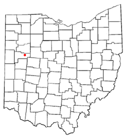
OHMap-doton-Uniopolis.png
Location of Uniopolis, Ohio
Map of Auglaize County Ohio Highlighting Uniopolis Village.png
Location of Uniopolis in Auglaize County
Coordinates: 40°36′08″N84°05′08″W / 40.60222°N 84.08556°W / 40.60222; -84.08556
Country United States
State Ohio
County Auglaize
Township Union
Area
[1]
  Total0.27 sq mi (0.69 km2)
  Land0.27 sq mi (0.69 km2)
  Water0.00 sq mi (0.00 km2)
Elevation
[2]
938 ft (286 m)
Population
 (2020)
  Total188
  Density706.77/sq mi (273.15/km2)
Time zone UTC-5 (Eastern (EST))
  Summer (DST) UTC-4 (EDT)
ZIP code
45888
Area code 419
FIPS code 39-78848 [3]
GNIS feature ID2785017 [2]

Uniopolis is an unincorporated community and former village in Auglaize County, Ohio, United States. The population was 188 at the 2020 census. It is included in the Wapakoneta, Ohio Micropolitan Statistical Area.

Contents

The community is served by the Wapakoneta City School District.

History

Uniopolis was founded in 1837 and incorporated in 1900. [4] [5] In 2013, voters chose to disincorporate Uniopolis into Union Township. [6]

Its village hall, now a museum, [7] is listed on the National Register of Historic Places. [8]

Geography

According to the United States Census Bureau, the village had a total area of 0.16 square miles (0.41 km2), all land. [9]

Demographics

Historical population
CensusPop.Note
1880 116
1910 245
1920 193−21.2%
1930 1972.1%
1940 22011.7%
1950 27123.2%
1960 29810.0%
1970 291−2.3%
1980 259−11.0%
1990 2610.8%
2000 256−1.9%
2010 222−13.3%
2020 188−15.3%
U.S. Decennial Census [10]

2010 census

As of the census [11] of 2010, there were 222 people, 83 households, and 64 families living in the village. The population density was 1,387.5 inhabitants per square mile (535.7/km2). There were 96 housing units at an average density of 600.0 per square mile (231.7/km2). The racial makeup of the village was 100.0% White.

There were 83 households, of which 27.7% had children under the age of 18 living with them, 65.1% were married couples living together, 7.2% had a female householder with no husband present, 4.8% had a male householder with no wife present, and 22.9% were non-families. 16.9% of all households were made up of individuals, and 3.6% had someone living alone who was 65 years of age or older. The average household size was 2.67 and the average family size was 2.97.

The median age in the village was 41.5 years. 18.9% of residents were under the age of 18; 11.4% were between the ages of 18 and 24; 24% were from 25 to 44; 28.5% were from 45 to 64; and 17.6% were 65 years of age or older. The gender makeup of the village was 52.3% male and 47.7% female.

2000 census

As of the census [3] of 2000, there were 256 people, 88 households, and 77 families living in the village. The population density was 1,640.3 inhabitants per square mile (633.3/km2). There were 93 housing units at an average density of 595.9 per square mile (230.1/km2). The racial makeup of the village was 98.83% White, 0.39% African American, 0.39% Native American, and 0.39% from two or more races. Hispanic or Latino of any race were 1.17% of the population.

There were 88 households, out of which 44.3% had children under the age of 18 living with them, 71.6% were married couples living together, 10.2% had a female householder with no husband present, and 12.5% were non-families. 10.2% of all households were made up of individuals, and 3.4% had someone living alone who was 65 years of age or older. The average household size was 2.91 and the average family size was 3.08.

In the village the population was spread out, with 30.1% under the age of 18, 8.2% from 18 to 24, 31.6% from 25 to 44, 18.8% from 45 to 64, and 11.3% who were 65 years of age or older. The median age was 33 years. For every 100 females, there were 113.3 males. For every 100 females age 18 and over, there were 113.1 males.

The median income for a household in the village was $37,083, and the median income for a family was $38,750. Males had a median income of $30,909 versus $24,375 for females. The per capita income for the village was $16,099. None of the population or families were below the poverty line.

Related Research Articles

<span class="mw-page-title-main">Auglaize County, Ohio</span> County in Ohio, United States

Auglaize County is a county in Northwestern Ohio, United States of America. As of the 2020 census, the population was 46,442. Its county seat and largest city is Wapakoneta.

<span class="mw-page-title-main">Fort Shawnee, Ohio</span> CDP in Ohio, United States

Fort Shawnee is census-designated place (CDP) in Allen County, Ohio, United States. The population was 6,263 at the 2020 census. It is included in the Lima, Ohio Metropolitan Statistical Area. Fort Shawnee is adjacent to the city of Lima and the village of Cridersville in Auglaize County. In 2012, village residents voted to disincorporate the village. Fort Shawnee is located at 40°40′54″N84°8′21″W. According to the United States Census Bureau, the village had a total area of 7.25 square miles (18.78 km2), of which 7.21 square miles (18.67 km2) is land and 0.04 square miles (0.10 km2) is water.

<span class="mw-page-title-main">Buckland, Ohio</span> Village in Ohio, United States

Buckland is a village in Auglaize County, Ohio, United States. The population was 233 at the 2020 census. It is included in the Wapakoneta, Ohio Micropolitan Statistical Area. The village is served by the Wapakoneta City School District.

<span class="mw-page-title-main">Cridersville, Ohio</span> Village in Ohio, United States

Cridersville is a village in Auglaize County, Ohio, United States. The population was 1,791 at the 2020 census. It is included in the Wapakoneta, Ohio Micropolitan Statistical Area.

<span class="mw-page-title-main">Minster, Ohio</span> Village in Ohio, United States

Minster is a village in Auglaize and Shelby counties, in the U.S. state of Ohio. The population was 3,046 at the 2020 census. It is included in the Wapakoneta, Ohio Micropolitan Statistical Area. It is adjacent to the village of New Bremen to the north.

<span class="mw-page-title-main">New Bremen, Ohio</span> Village in Ohio, United States

New Bremen is a village in Auglaize County, Ohio, United States. The population was 3,034 at the 2020 census. It is included in the Wapakoneta, Ohio Micropolitan Statistical Area. The village is adjacent to Minster to the south.

<span class="mw-page-title-main">New Knoxville, Ohio</span> Village in Ohio, United States

New Knoxville is a village in Auglaize County, Ohio, United States. It was established in 1836. The population was 946 at the 2020 census. It is included in the Wapakoneta, Ohio Micropolitan Statistical Area.

<span class="mw-page-title-main">St. Marys, Ohio</span> City in Ohio, United States

St. Marys is a city in Auglaize County, Ohio, United States. Located in western Ohio, it is 11 miles (18 km) west of Wapakoneta and 20 miles (32 km) east of the Ohio–Indiana border. Founded in 1823, the city is located on a portage between the St. Marys and Auglaize river systems, which was a significant factor in its development before the era of canals. The population was 8,397 at the 2020 census. It is included in the Wapakoneta micropolitan area.

<span class="mw-page-title-main">Wapakoneta, Ohio</span> City in Ohio, United States

Wapakoneta is a city in and the county seat of Auglaize County, Ohio, United States. Located along the Auglaize River, the city is about 56 miles (90 km) north of Dayton and 83 miles (134 km) south of Toledo. The population was 9,957 at the 2020 census. It is the principal city of the Wapakoneta micropolitan area, which is included in the Lima–Van Wert–Celina combined statistical area.

<span class="mw-page-title-main">Waynesfield, Ohio</span> Village in Ohio, United States

Waynesfield is a village in Auglaize County, Ohio, United States. The population was 749 at the 2020 census. It is included in the Wapakoneta, Ohio Micropolitan Statistical Area.

<span class="mw-page-title-main">Midland, Ohio</span> Village in Ohio, United States

Midland is a village in Clinton County, Ohio, United States. The population was 307 at the 2020 census.

<span class="mw-page-title-main">Ithaca, Ohio</span> Village in Ohio, United States

Ithaca is a village in Darke County, Ohio, United States. The population was 81 at the 2020 census.

<span class="mw-page-title-main">Yorkshire, Ohio</span> Village in Ohio, United States

Yorkshire is a village in Darke County, Ohio, United States. The population was 95 at the 2020 census.

<span class="mw-page-title-main">Addyston, Ohio</span> Village in Ohio, United States

Addyston is a village in Miami Township, Hamilton County, Ohio, United States. Located along the Ohio River, it is a western suburb of the neighboring city of Cincinnati. The population was 927 at the 2020 census.

<span class="mw-page-title-main">Elmwood Place, Ohio</span> Village in Hamilton County, Ohio, United States

Elmwood Place is a village in Hamilton County, Ohio, United States. The population was 2,087 at the 2020 census. Except for a small portion which touches neighboring St. Bernard, Elmwood Place is nearly surrounded by the city of Cincinnati.

<span class="mw-page-title-main">Otway, Ohio</span> Village in Ohio, United States

Otway is a village in Scioto County, Ohio, United States. The population was 92 at the 2020 census.

<span class="mw-page-title-main">Botkins, Ohio</span> Village in Ohio, United States

Botkins is a village in Shelby County, Ohio, United States. The population was 1,155 at the 2020 census.

<span class="mw-page-title-main">Port Jefferson, Ohio</span> Village in Ohio, United States

Port Jefferson is a village in Salem Township, Shelby County, Ohio, United States. The population was 308 at the 2020 census.

<span class="mw-page-title-main">Venedocia, Ohio</span> Village in Ohio, United States

Venedocia is a village in Van Wert County, Ohio, United States. The population was 140 at the 2020 census. It is included within the Van Wert, Ohio Micropolitan Statistical Area and the Lima-Van Wert-Wapakoneta, OH Combined Statistical Area.

<span class="mw-page-title-main">Wilson, Ohio</span> Village in Ohio, United States

Wilson is a village in Belmont and Monroe counties in the U.S. state of Ohio. The population was 129 at the 2020 census. It is part of the Wheeling metropolitan area.

References

  1. "ArcGIS REST Services Directory". United States Census Bureau. Retrieved September 20, 2022.
  2. 1 2 U.S. Geological Survey Geographic Names Information System: Uniopolis, Ohio
  3. 1 2 "U.S. Census website". United States Census Bureau . Retrieved January 31, 2008.
  4. Auglaize County, Ohio Atlas and History Archived June 11, 2011, at the Wayback Machine , Piqua: Magee Brother Publishing, 1917. Accessed 2007-12-30. 117.
  5. "Uniopolis Incorporation" (PDF). Auglaize County, Ohio. Retrieved September 25, 2021.
  6. Fugleberg, Jeremy (February 25, 2016). "Hit by floods and budget cuts, village to vote on disappearing". The Cincinnati Enquirer. Retrieved February 26, 2016.
  7. What to See, Auglaize County Historical Society, 2010. Accessed 2010-06-07.
  8. "National Register Information System". National Register of Historic Places . National Park Service. March 13, 2009.
  9. "US Gazetteer files 2010". United States Census Bureau. Archived from the original on January 12, 2012. Retrieved January 6, 2013.
  10. "Census of Population and Housing". Census.gov. Retrieved June 4, 2015.
  11. "U.S. Census website". United States Census Bureau . Retrieved January 6, 2013.