Vail, Pennsylvania | |
---|---|
Coordinates: 40°42′04″N78°12′50″W / 40.70111°N 78.21389°W | |
Country | United States |
State | Pennsylvania |
County | Blair |
Township | Snyder |
Area | |
• Total | 0.15 sq mi (0.40 km2) |
• Land | 0.15 sq mi (0.40 km2) |
• Water | 0.0 sq mi (0.0 km2) |
Elevation | 1,020 ft (310 m) |
Time zone | UTC-5 (Eastern (EST)) |
• Summer (DST) | UTC-4 (EDT) |
ZIP Code | 16686 (Tyrone) |
Area code(s) | 814/582 |
FIPS code | 42-79496 |
GNIS feature ID | 2805576 [2] |
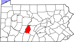
Vail is an unincorporated community and census-designated place (CDP) in Blair County, Pennsylvania, United States. It was first listed as a CDP prior to the 2020 census. [2]
The CDP is in northern Blair County, in the eastern part of Snyder Township. It is bordered to the northwest by Bald Eagle Creek and to the southeast by Interstate 99/U.S. Route 220. South Eagle Valley Road (old US 220) is the main road through the community; it leads southwest 9 miles (14 km) to Tyrone and northeast 2 miles (3 km) to Bald Eagle.
The school district is the Tyrone Area School District. [3]
Blair County is a county in the Commonwealth of Pennsylvania. As of the 2020 census, the population was 122,822. Its county seat is Hollidaysburg, and its largest city is Altoona. The county was created on February 26, 1846, from parts of Huntingdon and Bedford counties. The county is part of the Southwest Pennsylvania region of the state.
Edwards is an unincorporated town, a post office, and a census-designated place (CDP) located in and governed by Eagle County, Colorado, United States. Edwards is the principal town of the Edwards, CO Micropolitan Statistical Area. The Edwards post office has the ZIP Code 81632. At the United States Census 2020, the population of the Edwards CDP was 11,246. The Edwards Metropolitan District provides services.
Snyder Township is a township in Blair County, Pennsylvania, United States. It is part of the Altoona, PA Metropolitan Statistical Area. The population was 3,345 at the 2020 census.
Tyrone is a borough in Blair County, Pennsylvania, United States, located 15 miles (24 km) northeast of Altoona, on the Little Juniata River. Tyrone was of considerable commercial importance in the twentieth century. It was an outlet for the Clearfield coal fields and was noted for manufacturing paper products. There were planing mills and chemical and candy factories. In 1900, 5,847 people lived here; in 1910, 7,176; and in 1940, 8,845 people resided here. The population was 5,477 at the 2010 census. It is part of the Altoona, PA Metropolitan Statistical Area. It was named after County Tyrone in Ireland.
Bald Eagle is a Census-designated place in Blair County, Pennsylvania, United States. It is located in the Bald Eagle Valley at the foot of the Bald Eagle Mountain ridge, along the Big Fill Run near its confluence with the headwaters of the Bald Eagle Creek tributary of the Little Juniata River. Originally a stop on the Pennsylvania Railroad Tyrone Division, it is now exit 52 off Interstate 99, and was the former northern terminus of the unfinished highway. The Bald Eagle postal zip code is 16686.
Mount Eagle is an unincorporated community and census-designated place in Howard Township, Centre County, Pennsylvania, United States. As of the 2010 census, the population was 103.
Charlottsville is an unincorporated community and census-designated place (CDP) in Blair County, Pennsylvania, United States. It was first listed as a CDP prior to the 2020 census.
Elberta is an unincorporated community and census-designated place (CDP) in Blair County, Pennsylvania, United States. It was first listed as a CDP prior to the 2020 census.
Fostoria is an unincorporated community and census-designated place (CDP) in Blair County, Pennsylvania, United States. It was first listed as a CDP prior to the 2020 census.
Gray is an unincorporated community and census-designated place (CDP) in Blair County, Pennsylvania, United States. It was first listed as a CDP prior to the 2020 census.
Ironville is an unincorporated community and census-designated place (CDP) in Blair County, Pennsylvania, United States. It was first listed as a CDP prior to the 2020 census.
Nealmont is an unincorporated community and census-designated place (CDP) in Blair County, Pennsylvania, United States. It was first listed as a CDP prior to the 2020 census.
Olivia is an unincorporated community and census-designated place (CDP) in Blair County, Pennsylvania, United States. It was first listed as a CDP prior to the 2020 census.
Sickles Corner is an unincorporated community and census-designated place (CDP) in Blair County, Pennsylvania, United States. It was first listed as a CDP prior to the 2020 census.
Tyrone Forge is an unincorporated community and census-designated place (CDP) in Blair County, Pennsylvania, United States. It was first listed as a CDP prior to the 2020 census.
Wopsononock is an unincorporated community and census-designated place (CDP) in Blair County, Pennsylvania, United States. It was first listed as a CDP prior to the 2020 census.
Continental Courts is a mobile home park and census-designated place (CDP) in Centre County, Pennsylvania, United States. It was first listed as a CDP prior to the 2020 census.
Eagle Creek is a census-designated place (CDP) in Centre County, Pennsylvania, United States. It was first listed as a CDP prior to the 2020 census.
Holters Crossing is an unincorporated community and census-designated place (CDP) in Centre County, Pennsylvania, United States. It was first listed as a CDP prior to the 2020 census.
Moose Run is a census-designated place (CDP) in Centre County, Pennsylvania, United States. It was first listed as a CDP prior to the 2020 census.