Las Piñas, officially the City of Las Piñas, is a 1st class highly urbanized city in the National Capital Region of the Philippines. According to the 2015 census, it has a population of 588,894 people.
The Macanese people are an East Asian ethnic group that originated in Macau in the 16th century, consisting of people of predominantly mixed Cantonese and Portuguese as well as Malay, Japanese, English, Sinhalese, and Indian ancestry.

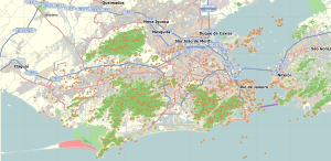
Flamengo is a neighborhood in Rio de Janeiro, Brazil.

Barra da Tijuca is a upper-class neighborhood or bairro in the West Zone of Rio de Janeiro, Brazil, located in the western portion of the city on the Atlantic Ocean. Barra is well known for its beaches, its many lakes and rivers, and its lifestyle. This neighbourhood represents 4.7% of the city population and 13% of the total area of Rio de Janeiro.
Jacarepaguá, with a land area of 29.27 square miles (75.8 km2), is a neighborhood situated in the West Zone of Rio de Janeiro, Brazil. In 2010, it had a population of 157,326. The name comes from the indigenous name of the location, "shallow pond of caymans", yakaré + upá (pond) + guá (shallow), by the time of the Portuguese colonization.
Laranjeiras is an upper-middle-class neighborhood located in the South Zone of Rio de Janeiro, Brazil. Primarily residential, It is one of the city's oldest neighborhoods, having been founded in the 17th century, with the construction of country houses in the valley located around the Carioca River, which bordered Corcovado Mountain. Because of this, the neighborhood was previously called Vale do Carioca, or Carioca Valley.
Maracanã is a middle-class neighborhood in the Northern Zone of Rio de Janeiro city. The Maracanã Stadium is located in this neighborhood, as well as the Ginásio do Maracanãzinho. Maracanã is bordered by these neighborhoods: Praça da Bandeira, Tijuca and Vila Isabel.

Ajuda is a freguesia and district of Lisbon, the capital of Portugal. Ajuda is located in western Lisbon, northeast of Belém and west of Alcântara. The population in 2011 was 15,617.
Bangu is a neighborhood in the West Zone of Rio de Janeiro, Brazil. It is a middle-class neighborhood. It is located in the western area of the city being one of the most populated districts, with 244,518 inhabitants [1] distributed in an area of 4570.69 ha. Located in the geographic center of the city, the neighborhood is close to Campo Grande, Senador Camará, Vila Aliança, Padre Miguel and Realengo. On November 22, 2004 the mayor of Rio de Janeiro César Maia created by decree the district Gericinó. The neighborhood was originally part of the neighborhood of Bangu, the region where the penitentiary of Bangu is located, besides Bangu dump. The region is where Gericinó was located containing the sub-district of the Aqueduct. Since 2004, the complex of Bangu and dump of Bangu, no longer belong to the neighborhood of Bangu.
Realengo is a neighborhood in the West Zone of Rio de Janeiro, Brazil. The lower and middle-class neighborhood is between the Mendanha and Pedra Branca mountains. It is located between the mountains of Pedra Branca and Mendanha in the northern of the called West Zone of the city, owned and names the XXXIII Administrative Region which encompasses the entire east around the neighborhood. Realengo usually has the highest temperatures in the city, even though the winter nights are often cold because of the proximity to the mountains. Created on November 20, 1815, every year on this day the city's birthday is celebrated with the Week of Realengo. Pedro I of Brazil and Pedro II of Brazil used to go to the farm of Santa Cruz by the Estrada Real de Santa Cruz, passing by Realengo, where he often stayed.
The neighborhood of Padre Miguel is situated in the western region of the city of Rio de Janeiro, is of middle class, and borders the neighborhoods of Bangu (west) and Realengo (east). The Mocidade Independente de Padre Miguel and Unidos de Padre Miguel schools of samba are located in Padre Miguel. On the weekend, another attraction is the Ponto Chic, bohemian stronghold of the neighborhood. Simonsen College and Castelo Branco University, two private colleges, are found in the West Zone. Padre Miguel has many excellent private schools, including Adventist School of Padre Miguel, Prioridade Hum and Simonsen High School.
Penha Circular is a neighborhood in the North Zone of Rio de Janeiro, Brazil It has been known for being a part of a bigger neighborhood called Penha but after it got too big, it was decided they should've been divided into more groups of neighborhoods like Penha, Bras de Pina, Vila da Penha and Penha Circular.
Méier is a middle class and upper middle class neighborhood in the North Zone of Rio de Janeiro, Brazil.
Engenho Novo is a neighborhood of middle class and lower middle of the North Zone of Rio de Janeiro, Brazil. It neighbors the neighborhoods Méier, Vila Isabel, Lins de Vasconcelos, Sampaio, Jacaré, Cachambi and Grajaú. It has 264.48 hectares of land area. It is part of a region called the Grande Méier encompassing the neighborhoods of the Abolição, Água Santa, Cachambi, Encantado, Engenho de Dentro, Jacaré, Lins de Vasconcelos, Méier, Piedade, Pilares, Riachuelo, Rocha, Sampaio, São Francisco Xavier and Todos os Santos. It is the fifth largest district population group.
Irajá is a neighborhood of middle class and lower middle in the North Zone of Rio de Janeiro, Brazil. The neighborhood is divided by Brazil Avenue. Today it is a neighborhood of medium size, with a little more than 100,000 inhabitants.

Abolição (Abolition) is a middle-class neighborhood of the North Zone of the city of Rio de Janeiro, Brazil.
Glória is a middle-class neighborhood of the city of Rio de Janeiro, Brazil. It is located between the neighbourhoods of Centro and Flamengo, Rio de Janeiro.

Catete is a neighborhood in the South Zone of Rio de Janeiro, Brazil. It has strong commerce, with the majority of population being middle class.
Jardim Sulacap is a neighborhood in the West Zone of Rio de Janeiro, Brazil.
Saúde is a neighborhood of Rio de Janeiro, Brazil. Its population in 2000 was 2186. Located on the coast, just north of the historical centre in downtown Rio, west of Praça Maua and east of Gamboa, Rio de Janeiro. It contains several notable hospitals such as Hospital dos Servidores de Estado and Hospital Pro Matre; the name Saúde means "Health" in Portuguese. It is marked by many homes for the lower middle class and numerous sheds, warehouses and depots are located in the region.