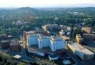
Charlottesville, colloquially known as C'ville, is an independent city in the Commonwealth of Virginia. It is the county seat of Albemarle County, which surrounds the city, though the two are separate legal entities. It is named after Queen Charlotte. As of the 2020 census, the population was 46,553. The Bureau of Economic Analysis combines the City of Charlottesville with Albemarle County for statistical purposes, bringing its population to approximately 150,000. Charlottesville is the heart of the Charlottesville metropolitan area, which includes Albemarle, Buckingham, Fluvanna, Greene, and Nelson counties.

Amherst is a town in Amherst County, Virginia, United States. The population was 2,231 at the 2010 census. It is the county seat of Amherst County.

Gordonsville is a town in Orange County in the Commonwealth of Virginia in the United States. Located about 19 miles northeast of Charlottesville and 65 miles northwest of Richmond, the population was 1,496 at the 2010 census.

Buildings, sites, districts, and objects in Virginia listed on the National Register of Historic Places:

Sperryville is a census-designated place (CDP) located in the western section of Rappahannock County, Virginia, United States, near Shenandoah National Park. It consists of a village with two main streets along the two branches of the Thornton River, together with surrounding pasture- and farmland. The population as of the 2010 Census was 342.

Palmyra is a census-designated place (CDP) in and the county seat of Fluvanna County, Virginia, United States. The population as of the 2010 census was 104. Palmyra lies on the eastern bank of the Rivanna River along U.S. Route 15. The ZIP code for Palmyra and surrounding rural land is 22963.
West Main Street Historic District, or West Main Street District or variations, may refer to:

This is a list of the National Register of Historic Places listings in Accomack County, Virginia.

This is a list of the National Register of Historic Places listings in Charlottesville, Virginia.
This is a list of the National Register of Historic Places listings in Augusta County, Virginia.

This is a list of the National Register of Historic Places listings in Smyth County, Virginia.

Woolen Mills Village Historic District is a historic district that was listed on the National Register of Historic Places on April 12, 2010. The district is in Albemarle County, Virginia and also in Charlottesville, Virginia.
Mowbray and Uffinger comprised an architectural partnership in New York City formed in 1895. Known for bank buildings and as vault engineers they designed over 400 banks in the pre-World War II era throughout the country. The principals were Louis Montayne Mowbray (1867-1921) and Justin Maximo Uffinger Sr. (1871-1948).

The Museum District, alternately known as West of the Boulevard, is a neighborhood in the city of Richmond, Virginia. It is anchored by the contiguous six-block tract of museums along the west side of Boulevard, including the Virginia Museum of Fine Arts and the Virginia Museum of History & Culture, hence the name.
Scottsville Historic District is a national historic district located at Scottsville, Albemarle County and Fluvanna County, Virginia. The district encompasses 153 contributing buildings, 1 contributing site, and 4 contributing structures in the town of Scottsville. The district includes commercial, residential, religious, factory and warehouse buildings in a variety of popular architectural styles including Federal, Georgian, Greek Revival, Gothic Revival, Italianate, Queen Anne, Prairie, Colonial Revival, and Craftsman. Notable buildings include Scottsville High School (1920), Riverview (1817), Chester (1847), Belle Haven, Oakwood, Herndon House (1800), The Tavern (mid-1700s), Scottsville Presbyterian Church (1832), Disciples Church (1846), Coleman's Store (1914), and the Fore House (1732). Located in the district and separately listed are Cliffside and Mount Walla.
Orange Commercial Historic District is a national historic district located at Orange, Orange County, Virginia. One of Virginia's Main Street communities, it encompasses 61 contributing buildings in the central business district of Orange's county seat.
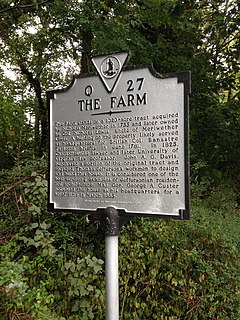
The historic home listed as Lewis Farm, also known as The Farm and John A. G. Davis Farm, is located at Charlottesville, Virginia. It was built in 1826, and is a two-story brick dwelling with a low hipped roof and two large chimneys. On the front facade is a Tuscan order portico with a terrace above. The house was built by individuals who worked with Thomas Jefferson on building the University of Virginia. Its builder, John A. G. Davis, was law professor at the University of Virginia and was shot and killed outside Pavilion X by a student in 1840. During the American Civil War, Brigadier General George Armstrong Custer set up temporary headquarters at the house where he remained for three days.

John Vowles House is two adjoined historic homes located at Charlottesville, Virginia. It was built in 1824, and consists of two two-story, three-bay, gable-roofed Federal style brick town houses. Both houses feature decorative cornices and original interior woodwork. To the rear of 1113 West Main is a small 1+1⁄2-story, "L"-shaped, gable-roofed brick outbuilding built as a kitchen and added in the 1920s.

Fifeville and Tonsler Neighborhood Historic District is a national historic district located at Charlottesville, Virginia. The district encompasses 264 contributing buildings and 3 contributing sites in a predominantly African-American residential section of the city of Charlottesville. It was developed between 1890 and the 1930s and includes examples of the Bungalow and Gothic Revival styles. The oldest is dated to 1822. Located in the district are the separately listed Oak Lawn, Benjamin Tonsler House, Delevan Baptist Church, and Gardner-Mays Cottage.

The Fry's Spring Historic District encompasses a residential neighborhood of Charlottesville, Virginia, which was developed between 1890 and 1963. Prior to its development, it was a largely wooded area owned for much of the 19th century by the Fry family. The 150-acre (61 ha) district is centered on the private Fry's Spring Beach Club, whose property includes the eponymous spring, and includes 300 mainly residential buildings with historic character. The architectural styles that predominate in the district are Craftsman and Colonial Revival, although other revival styles such as the Spanish and Tudor Revival are represented by smaller numbers of buildings. There are also four churches in the district. The district extends southward along Jefferson Park Avenue, south of the railroad tracks, and radiates out along Stribling, Todd, Robert, and Raymond Avenues as far as Highland Avenue. Another cluster of streets at the southern end of the district includes Jefferson Park Circle, and portions of Eton Road and Monte Vista Avenue.


